ZIP Code: 67572, Ransom, KS
ZIP Code 67572 is located in Ransom, Kansas. Its detail State, County, City, Longitude, Latitude, Envelope Example, Population is as below.
, capturing its rural beauty and agricultural character, integrating a vintage postcard design with modern postal elements, highlighting state flag and ZIP code '67572'.")
ZIP Code 67572 Information

-
-
Country:
U.S. - United States
State:
County FIPS:
20135
County:
City:
Area Code:
City Type ?In many cases, a ZIP Code can have multiple "names", meaning cities, towns, or subdivisions, in its boundaries. However, it will ALWAYS have exactly 1 "default" name. D - Default - This is the "preferred" name - by the USPS - for a city. Each ZIP Code has one - and only one - "default" name. In most cases, this is what people who live in that area call the city as well. A - Acceptable - This name can be used for mailing purposes. Often times alternative names are large neighborhoods or sections of the city/town. In some cases a ZIP Code may have several "acceptable" names which is used to group towns under one ZIP Code. N - Not Acceptable - A "not acceptable" name is, in many cases, a nickname that residents give that location. According to the USPS, you should NOT send mail to that ZIP Code using the "not acceptable" name when mailing.:
D (Default)
ZIP Code:
67572
❓What does D (Default) mean? This is the "preferred" name - by the USPS - for a city. Each ZIP Code has one - and only one - "default" name. In most cases, this is what people who live in that area call the city as well.
-


-
Iconic US Landmark Legacy Designs
Get PNG, SVG, EPS, AI, PDF Versions at Just $0.1
 Download Now
-


ZipCodeCraft
ZIP Code 67572 Plus 4
ZIP Code 5 plus 4 is the extension of 5-digit zip code, It can be used to locate a more detailed location. The last four digits designate segment or one side of a street or an apartment. You can find the ZIP+4 code and corresponding address of the zip code 67572 below.
| ZIP Code 5 Plus 4 | Address |
|---|---|
| 67572-0001 | PO BOX 1, RANSOM, KS |
| 67572-0091 | PO BOX 91, RANSOM, KS |
| 67572-0181 | PO BOX 181, RANSOM, KS |
| 67572-7000 | 200 E 1ST ST, RANSOM, KS |
| 67572-7001 | 14065 STATE HIGHWAY 4, RANSOM, KS |
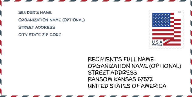
Envelope Example

This is an example of a US zip envelope. You can use a 5-digit zipcode or a detailed 9-digit zipcode to copy the mail in the following address format.
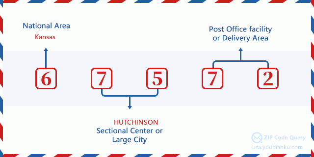
67572 Basic Meaning
What does each digit of ZIP Code 67572 stands for? The first digit designates a national area, which ranges from zero for the Northeast to nine for the far West. The 2-3 digits are the code of a sectional center facility in that region. The last two digits designate small post offices or postal zones.
Online Map

This is online map of the address Ransom, Kansas, United States. You may use button to move and zoom in / out. The map information is for reference only.
Hospital

This is the ZIP Code 67572 - Hospital page list. Its detail Hospital Name, Street, City, State, ZIP Code, Phone is as below.
- Name: GRISELL MEMORIAL HOSPITAL
- Address: RANSOM
- City: 210 SOUTH VERMONT AVENUE
- State: KS
- ZIP Code: 67572
- Phone: (785) 731-2231
Library

This is the ZIP Code 67572 - Library page list. Its detail Library Name, Address, City, State, ZIP Code, Phone is as below.
- Name: RANSOM PUBLIC LIBRARY
- Address: 411 S. VERMONT
- City: RANSOM
- State: KS - Kansas
- ZIP Code: 67572
- Phone: (785) 731-2855
School

This is the ZIP Code 67572 - School page list. Its detail School Name, Address, City, State, ZIP Code is as below.
- School Name: Western Plains North Elem
- Address: 100 School St.
- City: Ransom
- State: KS
- Grades: UG
- ZIP Code: 67572
Population for ZIP Code 67572

What is the total population in ZIP Code 67572? Below is detail information.
- Population for ZIP Code 67572: 267
- 2010 Population: 456
The 2020 demographic statistics are in progress. The current population in ZIP code 67572 is 267, and the population in 2010 is 456.
Gender

In all the statistical population, the male population is 222, the female population is 234.
- Male Population: 222
- Female Population: 234
Race

In all the statistical population, the male population is 222, the female population is 234.
- White Population: 449
- Black Population: 3
- Hispanic Population: 10
- Asian Population: 1
- Hawaiian Population: 0
- Indian Population: 1
- Other Population: 5
Age

In all the statistical population, the White population is 449, the Black population is 3, the Hispanic population is 10, the Asian population is 1, the Hawaiian population is 0, the Indian Ppopulation is 1 and Other population is 5.
- Age's Median: 52.5
- Median of male age: 52.3
- Median of female age: 52.6
Households for ZIP Code 67572
ZIP code 67572 has 203 households, with an average number of 2.12 persons per household. The average income per household in Zip code 67572 is 46,250 USD, and the average house value is 64,300 USD.
- Households Per Zipcode: 203
- Persons Per Household: 2.12
- Average House Value: 64,300
- Income Per Household: 46,250
Geographic

The latitude of the Zip code 67572 is 38.624194, the longitude is -99.917890, and the elevation is 2490. It has land area of 210.644 square miles, and water area of 4.521 square miles. The time zone for ZIP code 67572 is Central (GMT -06:00). Daylight saving time should be observed in the area where the zip code is located.
- Latitude: 38.624194
- Longitude: -99.917890
- Elevation: 2490
- Land Area: 210.644
- Water Area: 4.521
- Time Zone: Central (GMT -06:00)
- Region: Midwest
- Division: West North Central
- Day Light Saving: Y
Congressional District

The Congressional District for ZIP code 67572 is Kansas's 1st congressional district, the Congressional Land Area is 52542.5 square mile.
- Congressional District: 1st
- Congressional Land Area: 52542.5
Delivery

In the ZIP code 67572, there are 126 residential delivery mailboxes and centralized units, and 3 commercial delivery mailbox and centralized units, 126 single family deliveries and 0 multifamily deliveries, and the box count is 245. The main post office does not have city delivery carrier routes for the ZIP code 67572.
- Delivery Residential: 126
- Delivery Business: 3
- Delivery Total: 245
- Single Family Delivery Units: 126
- Multi Family Delivery Units: 0
- City Delivery Indicator: N
Business

In ZIP code 67572, the number of business is 11, the number of employee is 116, the business first quarter payroll is 926,000 USD, the business annual payroll is 3,875,000 USD.
- Number Of Businesses: 11
- Number Of Employees: 116
- Business First Quarter Payroll: 926,000
- Business Annual Payroll: 3,875,000
Social Security Benefits

There are 130 beneficiaries with benefits in current-payment status for ZIP code 67572, of which 100 are retired workers, 15 are disabled workers, 10 are widow(er)s and parents, 5 are spouses and 0 are children. The number of beneficiaries aged 65 or older is 110. The total monthly benefits are 179,000 USD, of which 138,000 USD for retired workers, 15,000 USD for widow(er)s and parents.
- Total Number: 130
- Retired workers Number: 100
- Disabled workers Number: 15
- Widow(er)s and parents Number: 10
- Spouses Number: 5
- Children Number: 0
- All beneficiaries per month: 179,000
- Retired workers per month: 138,000
- Widow(er)s and parents per month: 15,000
- Number of beneficiaries aged 65 or older: 110


Add new comment