Verenigde Staten Postcode: 01002
Dit is de paginalijst van Massachusetts Postcode 01002. Hieronder is het detail van Staat, Graafschap, Stad, Lengte, Breedtegraad, Envelop Voorbeeld, Bevolking.

Postcode 01002 Informatie

-
-
Land:
U.S. - Verenigde Staten
Staat:
Staat FIPS:
25
Netnummer:
Postcode:
01002
Postcode Type:
S (Standard)
❓Wat betekent S (Standard)? Een "standaard" postcode is waar de meeste mensen aan denken als ze het over postcodes hebben - in wezen een stad, een stad of een afdeling van een stad die een postdienst heeft.
Postcode 01002 - Stad

Dit is de stadsinformatie die overeenkomt met 01002:
| Staat | Graafschap | Stad | Stadtype ?In many cases, a ZIP Code can have multiple "names", meaning cities, towns, or subdivisions, in its boundaries. However, it will ALWAYS have exactly 1 "default" name. D - Default - This is the "preferred" name - by the USPS - for a city. Each ZIP Code has one - and only one - "default" name. In most cases, this is what people who live in that area call the city as well. A - Acceptable - This name can be used for mailing purposes. Often times alternative names are large neighborhoods or sections of the city/town. In some cases a ZIP Code may have several "acceptable" names which is used to group towns under one ZIP Code. N - Not Acceptable - A "not acceptable" name is, in many cases, a nickname that residents give that location. According to the USPS, you should NOT send mail to that ZIP Code using the "not acceptable" name when mailing. | Postcode |
|---|---|---|---|---|
| MA | Hampshire | Amherst | D (Default) | 01002 |
| MA | Hampshire | Cushman | A (Acceptable) | 01002 |
| MA | Hampshire | Pelham | A (Acceptable) | 01002 |
| MA | Hampshire | South Amherst | N (Not Acceptable) | 01002 |
❓Wat betekent D (Default)? Dit is de "geprefereerde" naam - door de USPS - voor een stad. Elke postcode heeft één - en slechts één - "standaard" naam. In de meeste gevallen noemen mensen die in dat gebied wonen de stad ook.
❓Wat betekent A (Acceptable)? Deze naam kan worden gebruikt voor mailingdoeleinden. Vaak zijn alternatieve namen grote buurten of delen van de stad / stad. In sommige gevallen kan een postcode meerdere "acceptabele" namen hebben die worden gebruikt om steden onder één postcode te groeperen.
❓Wat betekent N (Not Acceptable)? Een "niet acceptabele" naam is in veel gevallen een bijnaam die bewoners aan die locatie geven. Volgens de USPS mag je GEEN post naar die postcode sturen met de "niet acceptabele" naam bij het mailen.
Postcode 01002 Plus 4
ZIP Code 5 plus 4 is de uitbreiding van de 5-cijferige postcode, het kan worden gebruikt om een meer gedetailleerde locatie te vinden. De laatste vier cijfers duiden een segment of een kant van een straat of een appartement aan. Hieronder vindt u de postcode en het bijbehorende adres van de postcode 01002.
| Postcode 5 Plus 4 | Adres |
|---|---|
| 01002-0001 | 1 UNIVERSITY OF MASS, AMHERST, MA |
| 01002-1000 | 400 OLD MONTAGUE RD, AMHERST, MA |
| 01002-1001 | 207 MONTAGUE RD, AMHERST, MA |
| 01002-1002 | 200 MONTAGUE RD, AMHERST, MA |
| 01002-1003 | 301 MONTAGUE RD, AMHERST, MA |
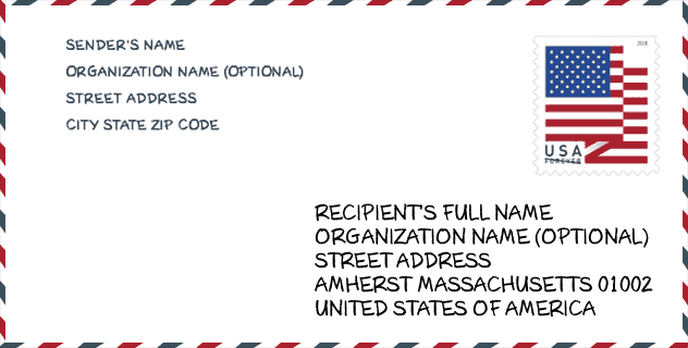
Envelop Voorbeeld

Dit is een voorbeeld van een Amerikaanse postenvelop. U kunt een 5-cijferige postcode of een gedetailleerde 9-cijferige postcode gebruiken om de mail in het volgende adresformaat te kopiëren.
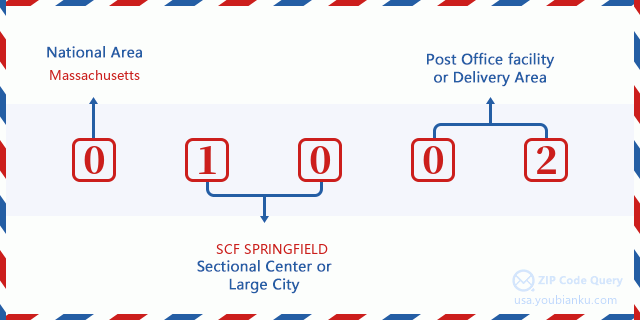
01002 Basisbetekenis
Waar staat elk cijfer van postcode 01002 voor? Het eerste cijfer geeft een nationaal gebied aan, dat varieert van nul voor het noordoosten tot negen voor het verre westen. De 2-3 cijfers zijn de code van een sectiecentrumfaciliteit in die regio. De laatste twee cijfers duiden kleine postkantoren of postzones aan.
Online landkaart

Het is een online kaart van adres South Amherst, Massachusetts, United States. U kunt Knopje gebruiken te in/uitzoomen. De kaartinformatie is alleen ter referentie.
Museum

Dit is de paginalijst van Postcode 01002 - Museum. Hieronder is het detail van Museum Naam, Straat, Stad, Staat, Postcode, Telefoon.
| Naam | Straat | Stad | Staat | Postcode | Telefoon |
| PELHAM HISTORICAL SOCIETY MUSEUM | 376 AMHERST RD | PELHAM | MA | 01002 | (413) 253-7313 |
| EMILY DICKINSON: THE HOMESTEAD AND THE EVERGREENS | 280 MAIN ST | AMHERST | MA | 01002 | (413) 542-2152 |
| AMHERST HISTORY MUSEUM AT THE STRONG HOUSE | 67 AMITY STREET | AMHERST | MA | 01002 | (413) 256-0678 |
| PELHAM HISTORICAL SOCIETY | POB 2824 | AMHERST | MA | 01002 | (413) 253-7313 |
| YIDDISH BOOK CENTER | 1021 WEST STREET | AMHERST | MA | 01002 | |
| BASSETT PLANETARIUM | BOLTWOOD AVENUE | AMHERST | MA | 01002 | |
| HAMPSHIRE COLLEGE OBSERVATORY | 893 WEST STREET | AMHERST | MA | 01002 | (413) 559-5378 |
| WILDER OBSERVATORY | BOLTWOOD AVENUE | AMHERST | MA | 01002 | |
| PRATT MUSEUM OF NATURAL HISTORY | 11 BARRETT HILL ROAD | AMHERST | MA | 01002 | (413) 542-2165 |
| AMHERST CENTER FOR RUSSIAN CULTURE | 11 BARRETT HILL ROAD | AMHERST | MA | 01002 | (413) 542-2350 |
| EMILY DICKINSON MUSEUM | 280 MAIN STREET | AMHERST | MA | 01002 | (413) 542-8161 |
| MEAD ART MUSEUM | 41 QUADRANGLE DRIVE | AMHERST | MA | 01002 | (413) 542-2335 |
Bibliotheek

Dit is de paginalijst van Postcode 01002 - Bibliotheek. Hieronder is het detail van Bibliotheek Naam, Adres, Stad, Staat, Postcode, Telefoon.
| Naam | Adres | Stad | Staat | Postcode | Telefoon |
|---|---|---|---|---|---|
| JONES LIBRARY, INC. | 43 AMITY STREET | AMHERST | MA | 01002 | (413) 259-3090 |
| MUNSON MEMORIAL LIBRARY | 1046 SOUTH EAST STREET | AMHERST | MA | 01002 | (413) 259-3095 |
| NORTH AMHERST LIBRARY | 8 MONTAGUE ROAD | AMHERST | MA | 01002 | (413) 259-3099 |
| PELHAM LIBRARY | 2 SOUTH VALLEY ROAD | PELHAM | MA | 01002 | (413) 253-0657 |
School

Dit is de paginalijst van Postcode 01002 - School. Hieronder is het detail van School Naam, Adres, Stad, Staat, Postcode.
| School Naam | Adres | Stad | Staat | Klassen | Postcode |
|---|---|---|---|---|---|
| Crocker Farm Elementary | 280 West Street | Amherst | MA | UG | 01002 |
| Fort River Elementary | 70 So East Street | Amherst | MA | UG | 01002 |
| Wildwood Elementary | 71 Strong Street | Amherst | MA | UG | 01002 |
| Amherst Regional High | 21 Mattoon Street | Amherst | MA | UG | 01002 |
| Amherst Regional Middle School | 170 Chestnut Street | Amherst | MA | UG | 01002 |
| Pelham Elementary | 45 Amherst Road | Pelham | MA | UG | 01002 |
Population for Postcode 01002

What is the total population in ZIP Code 01002? Below is detail information.
- Population for Postcode 01002: 25,959
- 2010 Bevolking: 29,049
The 2020 demographic statistics are in progress. The current population in ZIP code 01002 is 25,959, and the population in 2010 is 29,049.
Geslacht

In all the statistical population, the male population is 13,950, the female population is 15,099.
- Male Population: 13,950
- Female Population: 15,099
Race

In all the statistical population, the male population is 13,950, the female population is 15,099.
- White Population: 23,638
- Black Population: 2,002
- Hispanic Population: 2,283
- Asian Population: 3,480
- Hawaiian Population: 35
- Indian Population: 296
- Other Population: 970
Leeftijd

In all the statistical population, the White population is 23,638, the Black population is 2,002, the Hispanic population is 2,283, the Asian population is 3,480, the Hawaiian population is 35, the Indian Ppopulation is 296 and Other population is 970.
- Age's Median: 24.0
- Median of male age: 23.6
- Median of female age: 24.8
Households for Postcode 01002
ZIP code 01002 has 9,910 households, with an average number of 2.44 persons per household. The average income per household in Zip code 01002 is 55,858 USD, and the average house value is 355,600 USD.
- Households Per Zipcode: 9,910
- Personen per huishouden: 2.44
- Gemiddelde huiswaarde: 355,600
- Inkomen per huishouden: 55,858
Geographic

The latitude of the Zip code 01002 is 42.372901, the longitude is -72.450902, and the elevation is 732. It has land area of 55.065 square miles, and water area of 1.654 square miles. The time zone for ZIP code 01002 is Eastern (GMT -05:00). Daylight saving time should be observed in the area where the zip code is located.
- Breedtegraad: 42.372901
- Lengte: -72.450902
- Elevatie: 732
- Landoppervlak: 55.065
- Water Area: 1.654
- Tijd Zone: Eastern (GMT -05:00)
- Regio: Northeast
- Divisie: New England
- Zomertijd: Y
congresdistrict

The Congressional District for ZIP code 01002 is Massachusetts's 2nd congressional district, the Congressional Land Area is 1628 square mile.
- congresdistrict: 2nd
- Congresgebied: 1628
Levering

In the ZIP code 01002, there are 10,639 residential delivery mailboxes and centralized units, and 688 commercial delivery mailbox and centralized units, 6,427 single family deliveries and 2,150 multifamily deliveries, and the box count is 11,398. The main post office has city delivery carrier routes for the ZIP code 01002.
- Delivery Residential: 10,639
- Delivery Business: 688
- Delivery Total: 11,398
- Leveringseenheden voor één gezin: 6,427
- Multi Family Delivery Units: 2,150
- Stadsleveringsindicator: Y
Bedrijf

In ZIP code 01002, the number of business is 539, the number of employee is 7,972, the business first quarter payroll is 71,611,000 USD, the business annual payroll is 306,613,000 USD.
- Number Of Businesses: 539
- Number Of Employees: 7,972
- Zakelijke salarisadministratie eerste kwartaal: 71,611,000
- Zakelijke jaarlijkse loonlijst: 306,613,000


Reactie toevoegen