Postcode: 01069, Palmer, MA
Postcode 01069 bevindt zich in Palmer, Massachusetts. Het detail staat, provincie, stad, lengtegraad, breedtegraad, envelop Voorbeeld, Bevolking is zoals hieronder.

Postcode 01069 Informatie

-
-
Land:
U.S. - Verenigde Staten
Staat:
Regio FIPS:
25013
Graafschap:
Stad:
Netnummer:
Stadtype ?In many cases, a ZIP Code can have multiple "names", meaning cities, towns, or subdivisions, in its boundaries. However, it will ALWAYS have exactly 1 "default" name. D - Default - This is the "preferred" name - by the USPS - for a city. Each ZIP Code has one - and only one - "default" name. In most cases, this is what people who live in that area call the city as well. A - Acceptable - This name can be used for mailing purposes. Often times alternative names are large neighborhoods or sections of the city/town. In some cases a ZIP Code may have several "acceptable" names which is used to group towns under one ZIP Code. N - Not Acceptable - A "not acceptable" name is, in many cases, a nickname that residents give that location. According to the USPS, you should NOT send mail to that ZIP Code using the "not acceptable" name when mailing.:
D (Default)
Postcode:
01069
❓Wat betekent D (Default)? Dit is de "geprefereerde" naam - door de USPS - voor een stad. Elke postcode heeft één - en slechts één - "standaard" naam. In de meeste gevallen noemen mensen die in dat gebied wonen de stad ook.
Postcode 01069 Plus 4
ZIP Code 5 plus 4 is de uitbreiding van de 5-cijferige postcode, het kan worden gebruikt om een meer gedetailleerde locatie te vinden. De laatste vier cijfers duiden een segment of een kant van een straat of een appartement aan. Hieronder vindt u de postcode en het bijbehorende adres van de postcode 01069.
| Postcode 5 Plus 4 | Adres |
|---|---|
| 01069-0001 | PO BOX 1, PALMER, MA |
| 01069-0161 | PO BOX 161, PALMER, MA |
| 01069-0241 | PO BOX 241, PALMER, MA |
| 01069-0401 | PO BOX 401, PALMER, MA |
| 01069-0531 | PO BOX 531, PALMER, MA |
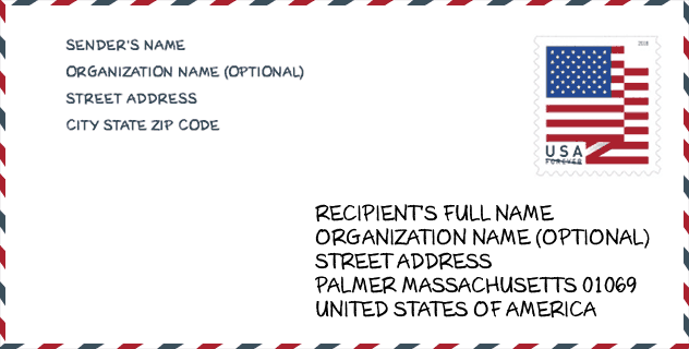
Envelop Voorbeeld

Dit is een voorbeeld van een Amerikaanse postenvelop. U kunt een 5-cijferige postcode of een gedetailleerde 9-cijferige postcode gebruiken om de mail in het volgende adresformaat te kopiëren.
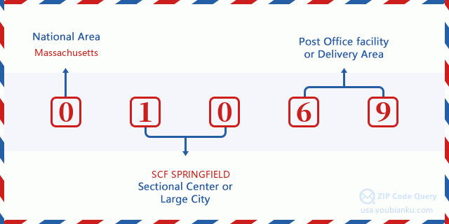
01069 Basisbetekenis
Waar staat elk cijfer van postcode 01069 voor? Het eerste cijfer geeft een nationaal gebied aan, dat varieert van nul voor het noordoosten tot negen voor het verre westen. De 2-3 cijfers zijn de code van een sectiecentrumfaciliteit in die regio. De laatste twee cijfers duiden kleine postkantoren of postzones aan.
Online landkaart

Het is een online kaart van adres Palmer, Massachusetts, United States. U kunt Knopje gebruiken te in/uitzoomen. De kaartinformatie is alleen ter referentie.
Ziekenhuis

Het is de Postcode 01069 - Ziekenhuis pagina lijst. Het detail Ziekenhuisnaam, straat, stad, staat, postcode, telefoon is zoals hieronder.
- Naam: BAYSTATE WING HOSPITAL
- Adres: PALMER
- Stad: 40 WRIGHT STREET
- Staat: MA
- Postcode: 01069
- Telefoon: (413) 283-7651
Museum

Dit is de paginalijst van Postcode 01069 - Museum. Hieronder is het detail van Museum Naam, Straat, Stad, Staat, Postcode, Telefoon.
- Naam: GICLEE OF NEW ENGLAND
- Straat: 1422 MAIN ST
- Stad: PALMER
- Staat: MA
- Postcode: 01069
- Telefoon: (413) 284-4344
School

Dit is de paginalijst van Postcode 01069 - School. Hieronder is het detail van School Naam, Adres, Stad, Staat, Postcode.
| School Naam | Adres | Stad | Staat | Klassen | Postcode |
|---|---|---|---|---|---|
| Palmer High | 4105 Main Street | Palmer | MA | UG | 01069 |
| Old Mill Pond | 4107 Main Street | Palmer | MA | UG | 01069 |
| Pathfinder Vocational Technical | 240 Sykes Street | Palmer | MA | UG | 01069 |
Population for Postcode 01069

What is the total population in ZIP Code 01069? Below is detail information.
- Population for Postcode 01069: 8,385
- 2010 Bevolking: 8,469
The 2020 demographic statistics are in progress. The current population in ZIP code 01069 is 8,385, and the population in 2010 is 8,469.
Geslacht

In all the statistical population, the male population is 4,228, the female population is 4,241.
- Male Population: 4,228
- Female Population: 4,241
Race

In all the statistical population, the male population is 4,228, the female population is 4,241.
- White Population: 8,230
- Black Population: 147
- Hispanic Population: 197
- Asian Population: 103
- Hawaiian Population: 5
- Indian Population: 66
- Other Population: 64
Leeftijd

In all the statistical population, the White population is 8,230, the Black population is 147, the Hispanic population is 197, the Asian population is 103, the Hawaiian population is 5, the Indian Ppopulation is 66 and Other population is 64.
- Age's Median: 43.5
- Median of male age: 42.3
- Median of female age: 44.7
Households for Postcode 01069
ZIP code 01069 has 3,519 households, with an average number of 2.36 persons per household. The average income per household in Zip code 01069 is 63,398 USD, and the average house value is 200,900 USD.
- Households Per Zipcode: 3,519
- Personen per huishouden: 2.36
- Gemiddelde huiswaarde: 200,900
- Inkomen per huishouden: 63,398
Geographic

The latitude of the Zip code 01069 is 42.192062, the longitude is -72.307682, and the elevation is 430. It has land area of 28.089 square miles, and water area of 0.29 square miles. The time zone for ZIP code 01069 is Eastern (GMT -05:00). Daylight saving time should be observed in the area where the zip code is located.
- Breedtegraad: 42.192062
- Lengte: -72.307682
- Elevatie: 430
- Landoppervlak: 28.089
- Water Area: 0.29
- Tijd Zone: Eastern (GMT -05:00)
- Regio: Northeast
- Divisie: New England
- Zomertijd: Y
congresdistrict

The Congressional District for ZIP code 01069 is Massachusetts's 1st|2nd congressional district, the Congressional Land Area is 2350.29|1628 square mile.
- congresdistrict: 1st|2nd
- Congresgebied: 2350.29|1628
Levering

In the ZIP code 01069, there are 3,553 residential delivery mailboxes and centralized units, and 305 commercial delivery mailbox and centralized units, 3,065 single family deliveries and 181 multifamily deliveries, and the box count is 4,180. The main post office has city delivery carrier routes for the ZIP code 01069.
- Delivery Residential: 3,553
- Delivery Business: 305
- Delivery Total: 4,180
- Leveringseenheden voor één gezin: 3,065
- Multi Family Delivery Units: 181
- Stadsleveringsindicator: Y
Bedrijf

In ZIP code 01069, the number of business is 260, the number of employee is 3,515, the business first quarter payroll is 38,278,000 USD, the business annual payroll is 172,110,000 USD.
- Number Of Businesses: 260
- Number Of Employees: 3,515
- Zakelijke salarisadministratie eerste kwartaal: 38,278,000
- Zakelijke jaarlijkse loonlijst: 172,110,000


Reactie toevoegen