Verenigde Staten Postcode: 47025
Dit is de paginalijst van Indiana Postcode 47025. Hieronder is het detail van Staat, Graafschap, Stad, Lengte, Breedtegraad, Envelop Voorbeeld, Bevolking.

Postcode 47025 Informatie

-
-
Land:
U.S. - Verenigde Staten
Staat:
Staat FIPS:
18
Netnummer:
Postcode:
47025
Postcode Type:
S (Standard)
❓Wat betekent S (Standard)? Een "standaard" postcode is waar de meeste mensen aan denken als ze het over postcodes hebben - in wezen een stad, een stad of een afdeling van een stad die een postdienst heeft.
Postcode 47025 - Stad

Dit is de stadsinformatie die overeenkomt met 47025:
| Staat | Graafschap | Stad | Stadtype ?In many cases, a ZIP Code can have multiple "names", meaning cities, towns, or subdivisions, in its boundaries. However, it will ALWAYS have exactly 1 "default" name. D - Default - This is the "preferred" name - by the USPS - for a city. Each ZIP Code has one - and only one - "default" name. In most cases, this is what people who live in that area call the city as well. A - Acceptable - This name can be used for mailing purposes. Often times alternative names are large neighborhoods or sections of the city/town. In some cases a ZIP Code may have several "acceptable" names which is used to group towns under one ZIP Code. N - Not Acceptable - A "not acceptable" name is, in many cases, a nickname that residents give that location. According to the USPS, you should NOT send mail to that ZIP Code using the "not acceptable" name when mailing. | Postcode |
|---|---|---|---|---|
| IN | Dearborn | Greendale | A (Acceptable) | 47025 |
| IN | Dearborn | Lawrenceburg | D (Default) | 47025 |
❓Wat betekent D (Default)? Dit is de "geprefereerde" naam - door de USPS - voor een stad. Elke postcode heeft één - en slechts één - "standaard" naam. In de meeste gevallen noemen mensen die in dat gebied wonen de stad ook.
❓Wat betekent A (Acceptable)? Deze naam kan worden gebruikt voor mailingdoeleinden. Vaak zijn alternatieve namen grote buurten of delen van de stad / stad. In sommige gevallen kan een postcode meerdere "acceptabele" namen hebben die worden gebruikt om steden onder één postcode te groeperen.
Postcode 47025 Plus 4
ZIP Code 5 plus 4 is de uitbreiding van de 5-cijferige postcode, het kan worden gebruikt om een meer gedetailleerde locatie te vinden. De laatste vier cijfers duiden een segment of een kant van een straat of een appartement aan. Hieronder vindt u de postcode en het bijbehorende adres van de postcode 47025.
| Postcode 5 Plus 4 | Adres |
|---|---|
| 47025-0900 | 3700 ROLLING RIDGE CT, LAWRENCEBURG, IN |
| 47025-0901 | 3701 ROLLING RIDGE CT, LAWRENCEBURG, IN |
| 47025-0902 | 3600 VALLEY RIDGE CT, LAWRENCEBURG, IN |
| 47025-0903 | 3601 VALLEY RIDGE CT, LAWRENCEBURG, IN |
| 47025-0904 | 3700 VALLEY RIDGE CT, LAWRENCEBURG, IN |
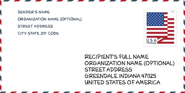
Envelop Voorbeeld

Dit is een voorbeeld van een Amerikaanse postenvelop. U kunt een 5-cijferige postcode of een gedetailleerde 9-cijferige postcode gebruiken om de mail in het volgende adresformaat te kopiëren.
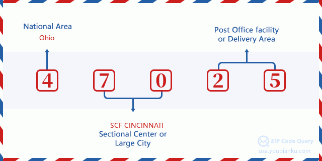
47025 Basisbetekenis
Waar staat elk cijfer van postcode 47025 voor? Het eerste cijfer geeft een nationaal gebied aan, dat varieert van nul voor het noordoosten tot negen voor het verre westen. De 2-3 cijfers zijn de code van een sectiecentrumfaciliteit in die regio. De laatste twee cijfers duiden kleine postkantoren of postzones aan.
Online landkaart

Het is een online kaart van adres Lawrenceburg, Indiana, United States. U kunt Knopje gebruiken te in/uitzoomen. De kaartinformatie is alleen ter referentie.
Universiteit

This is the ZIP Code 47025 - University page list. Its detail university Name, Street, City, State, ZIP Code, Phone is as below.
| Naam | Straat | Stad | Staat | Postcode | Telefoon |
| Veritas Baptist College | 181 US 50 E., Suite 204 | Greendale | IN | 47025 | (812) 221-1714 |
Ziekenhuis

Het is de Postcode 47025 - Ziekenhuis pagina lijst. Het detail Ziekenhuisnaam, straat, stad, staat, postcode, telefoon is zoals hieronder.
| Naam | Adres | Stad | Staat | Postcode | Telefoon |
|---|---|---|---|---|---|
| COMMUNITY MENTAL HEALTH CENTER INC | 285 BIELBY RD | LAWRENCEBURG | IN | 47025 | (812) 537-1302 |
| DEARBORN COUNTY HOSPITAL | 600 WILSON CREEK RD | LAWRENCEBURG | IN | 47025 | (812) 537-1010 |
Museum

Dit is de paginalijst van Postcode 47025 - Museum. Hieronder is het detail van Museum Naam, Straat, Stad, Staat, Postcode, Telefoon.
| Naam | Straat | Stad | Staat | Postcode | Telefoon |
| DEARBORN COUNTY HISTORICAL SOCIETY | 508 W HIGH ST | LAWRENCEBURG | IN | 47025 | (812) 537-4075 |
| SURVEYORS HISTORICAL SOCIETY | 628 RIDGE AVE | LAWRENCEBURG | IN | 47025 | (812) 537-2000 |
Bibliotheek

Dit is de paginalijst van Postcode 47025 - Bibliotheek. Hieronder is het detail van Bibliotheek Naam, Adres, Stad, Staat, Postcode, Telefoon.
| Naam | Adres | Stad | Staat | Postcode | Telefoon |
|---|---|---|---|---|---|
| LAWRENCEBURG PUBLIC LIBRARY DISTRICT | 150 MARY STREET | LAWRENCEBURG | IN | 47025 | (812) 537-2775 |
| MOBILE LIBRARY | 150 MARY STREET | LAWRENCEBURG | IN | 47025 | (812) 537-2775 |
School
Dit is de paginalijst van Postcode 47025 - School. Hieronder is het detail van School Naam, Adres, Stad, Staat, Postcode.
| School Naam | Adres | Stad | Staat | Klassen | Postcode |
|---|---|---|---|---|---|
| Central Elementary School | 500 Short St | Lawrenceburg | IN | UG | 47025 |
| Greendale Middle School | 200 Tiger Blvd | Lawrenceburg | IN | UG | 47025 |
| Lawrenceburg High School | 100 Tiger Blvd | Lawrenceburg | IN | UG | 47025 |
| Lawrenceburg Primary School | 400 Tiger Blvd | Lawrenceburg | IN | UG | 47025 |
| Bright Elementary School | 22593 State Line Rd | Lawrenceburg | IN | UG | 47025 |
Population for Postcode 47025

What is the total population in ZIP Code 47025? Below is detail information.
- Population for Postcode 47025: 24,105
- 2010 Bevolking: 22,932
The 2020 demographic statistics are in progress. The current population in ZIP code 47025 is 24,105, and the population in 2010 is 22,932.
Geslacht

In all the statistical population, the male population is 11,274, the female population is 11,658.
- Male Population: 11,274
- Female Population: 11,658
Race

In all the statistical population, the male population is 11,274, the female population is 11,658.
- White Population: 22,412
- Black Population: 400
- Hispanic Population: 281
- Asian Population: 174
- Hawaiian Population: 12
- Indian Population: 120
- Other Population: 142
Leeftijd

In all the statistical population, the White population is 22,412, the Black population is 400, the Hispanic population is 281, the Asian population is 174, the Hawaiian population is 12, the Indian Ppopulation is 120 and Other population is 142.
- Age's Median: 39.3
- Median of male age: 38.5
- Median of female age: 40.3
Households for Postcode 47025
ZIP code 47025 has 8,628 households, with an average number of 2.61 persons per household. The average income per household in Zip code 47025 is 66,241 USD, and the average house value is 167,100 USD.
- Households Per Zipcode: 8,628
- Personen per huishouden: 2.61
- Gemiddelde huiswaarde: 167,100
- Inkomen per huishouden: 66,241
Geographic

The latitude of the Zip code 47025 is 39.162674, the longitude is -84.891373, and the elevation is 680. It has land area of 55.403 square miles, and water area of 1.029 square miles. The time zone for ZIP code 47025 is Eastern (GMT -05:00). Daylight saving time should be observed in the area where the zip code is located.
- Breedtegraad: 39.162674
- Lengte: -84.891373
- Elevatie: 680
- Landoppervlak: 55.403
- Water Area: 1.029
- Tijd Zone: Eastern (GMT -05:00)
- Regio: Midwest
- Divisie: East North Central
- Zomertijd: Y
congresdistrict

The Congressional District for ZIP code 47025 is Indiana's 06th congressional district, the Congressional Land Area is 6206.83 square mile.
- congresdistrict: 06th
- Congresgebied: 6206.83
Levering

In the ZIP code 47025, there are 9,236 residential delivery mailboxes and centralized units, and 587 commercial delivery mailbox and centralized units, 7,819 single family deliveries and 580 multifamily deliveries, and the box count is 10,032. The main post office has city delivery carrier routes for the ZIP code 47025.
- Delivery Residential: 9,236
- Delivery Business: 587
- Delivery Total: 10,032
- Leveringseenheden voor één gezin: 7,819
- Multi Family Delivery Units: 580
- Stadsleveringsindicator: Y
Bedrijf

In ZIP code 47025, the number of business is 518, the number of employee is 8,527, the business first quarter payroll is 81,274,000 USD, the business annual payroll is 316,820,000 USD.
- Number Of Businesses: 518
- Number Of Employees: 8,527
- Zakelijke salarisadministratie eerste kwartaal: 81,274,000
- Zakelijke jaarlijkse loonlijst: 316,820,000
Sociale zekerheid

Er zijn 4,980 begunstigden met uitkeringen in de huidige betalingsstatus voor postcode 47025, waarvan 3,600 gepensioneerde werknemers, 665 gehandicapte werknemers, 285 weduwnaar (eren) en ouders, 150 zijn echtgenoten en 280 zijn kinderen. Het aantal begunstigden van 65 jaar of ouder is 3,790. De totale maandelijkse uitkeringen bedragen 7,365,000 USD, waarvan 5,746,000 USD voor gepensioneerde werknemers, 425,000 USD voor weduwnaar (eren) en ouders.
- Totaal aantal: 4,980
- Aantal gepensioneerden: 3,600
- Aantal gehandicapte werknemers: 665
- Weduwe / weduwnaar (er) en ouders Aantal: 285
- Echtgenoten nummer: 150
- Aantal kinderen: 280
- Alle begunstigden per maand: 7,365,000
- Gepensioneerde werknemers per maand: 5,746,000
- Weduwe (n) en ouders per maand: 425,000
- Aantal begunstigden van 65 jaar of ouder: 3,790


Reactie toevoegen