Postcode: 47167, Salem, IN
Postcode 47167 bevindt zich in Salem, Indiana. Het detail staat, provincie, stad, lengtegraad, breedtegraad, envelop Voorbeeld, Bevolking is zoals hieronder.

Postcode 47167 Informatie

-
-
Land:
U.S. - Verenigde Staten
Staat:
Regio FIPS:
18175
Graafschap:
Stad:
Netnummer:
Stadtype ?In many cases, a ZIP Code can have multiple "names", meaning cities, towns, or subdivisions, in its boundaries. However, it will ALWAYS have exactly 1 "default" name. D - Default - This is the "preferred" name - by the USPS - for a city. Each ZIP Code has one - and only one - "default" name. In most cases, this is what people who live in that area call the city as well. A - Acceptable - This name can be used for mailing purposes. Often times alternative names are large neighborhoods or sections of the city/town. In some cases a ZIP Code may have several "acceptable" names which is used to group towns under one ZIP Code. N - Not Acceptable - A "not acceptable" name is, in many cases, a nickname that residents give that location. According to the USPS, you should NOT send mail to that ZIP Code using the "not acceptable" name when mailing.:
D (Default)
Postcode:
47167
❓Wat betekent D (Default)? Dit is de "geprefereerde" naam - door de USPS - voor een stad. Elke postcode heeft één - en slechts één - "standaard" naam. In de meeste gevallen noemen mensen die in dat gebied wonen de stad ook.
Postcode 47167 Plus 4
ZIP Code 5 plus 4 is de uitbreiding van de 5-cijferige postcode, het kan worden gebruikt om een meer gedetailleerde locatie te vinden. De laatste vier cijfers duiden een segment of een kant van een straat of een appartement aan. Hieronder vindt u de postcode en het bijbehorende adres van de postcode 47167.
| Postcode 5 Plus 4 | Adres |
|---|---|
| 47167-0001 | PO BOX 1, SALEM, IN |
| 47167-0121 | PO BOX 121, SALEM, IN |
| 47167-0241 | PO BOX 241, SALEM, IN |
| 47167-0341 | PO BOX 341, SALEM, IN |
| 47167-0421 | PO BOX 421, SALEM, IN |
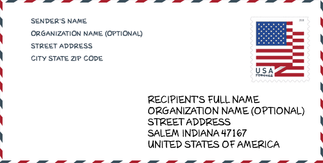
Envelop Voorbeeld

Dit is een voorbeeld van een Amerikaanse postenvelop. U kunt een 5-cijferige postcode of een gedetailleerde 9-cijferige postcode gebruiken om de mail in het volgende adresformaat te kopiëren.
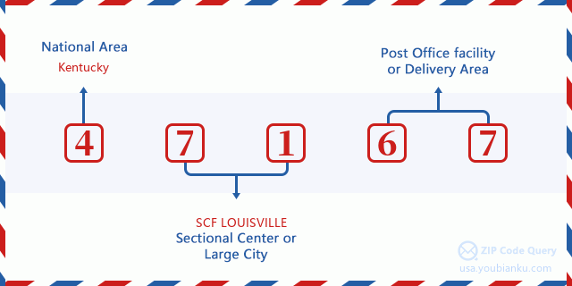
47167 Basisbetekenis
Waar staat elk cijfer van postcode 47167 voor? Het eerste cijfer geeft een nationaal gebied aan, dat varieert van nul voor het noordoosten tot negen voor het verre westen. De 2-3 cijfers zijn de code van een sectiecentrumfaciliteit in die regio. De laatste twee cijfers duiden kleine postkantoren of postzones aan.
Online landkaart

Het is een online kaart van adres Salem, Indiana, United States. U kunt Knopje gebruiken te in/uitzoomen. De kaartinformatie is alleen ter referentie.
Ziekenhuis

Het is de Postcode 47167 - Ziekenhuis pagina lijst. Het detail Ziekenhuisnaam, straat, stad, staat, postcode, telefoon is zoals hieronder.
- Naam: ST VINCENT SALEM HOSPITAL INC
- Adres: SALEM
- Stad: 911 N SHELBY ST
- Staat: IN
- Postcode: 47167
- Telefoon: (812) 883-5881
Museum

Dit is de paginalijst van Postcode 47167 - Museum. Hieronder is het detail van Museum Naam, Straat, Stad, Staat, Postcode, Telefoon.
| Naam | Straat | Stad | Staat | Postcode | Telefoon |
| HAY-MORRISON HOUSE | 106 S COLLEGE AVE | SALEM | IN | 47167 | |
| PIPER FLIGHT MUSEUM | 214 AVIATION CIRCLE | SALEM | IN | 47167 | (812) 883-9772 |
Bibliotheek

Dit is de paginalijst van Postcode 47167 - Bibliotheek. Hieronder is het detail van Bibliotheek Naam, Adres, Stad, Staat, Postcode, Telefoon.
- Naam: SALEM-WASHINGTON TOWNSHIP PUBLIC LIBRARY
- Adres: 212 NORTH MAIN STREET
- Stad: SALEM
- Staat: IN - Indiana
- Postcode: 47167
- Telefoon: (812) 883-5600
School

Dit is de paginalijst van Postcode 47167 - School. Hieronder is het detail van School Naam, Adres, Stad, Staat, Postcode.
| School Naam | Adres | Stad | Staat | Klassen | Postcode |
|---|---|---|---|---|---|
| Bradie Shrum Elementary | 11101 N Shelby St | Salem | IN | UG | 47167 |
| Salem High School | 700 N Harrison St | Salem | IN | UG | 47167 |
| Salem Middle School | 1001 N Harrison St | Salem | IN | UG | 47167 |
Population for Postcode 47167

What is the total population in ZIP Code 47167? Below is detail information.
- Population for Postcode 47167: 16,221
- 2010 Bevolking: 15,014
The 2020 demographic statistics are in progress. The current population in ZIP code 47167 is 16,221, and the population in 2010 is 15,014.
Geslacht

In all the statistical population, the male population is 7,350, the female population is 7,664.
- Male Population: 7,350
- Female Population: 7,664
Race

In all the statistical population, the male population is 7,350, the female population is 7,664.
- White Population: 14,844
- Black Population: 66
- Hispanic Population: 149
- Asian Population: 79
- Hawaiian Population: 1
- Indian Population: 95
- Other Population: 58
Leeftijd

In all the statistical population, the White population is 14,844, the Black population is 66, the Hispanic population is 149, the Asian population is 79, the Hawaiian population is 1, the Indian Ppopulation is 95 and Other population is 58.
- Age's Median: 39.5
- Median of male age: 38.6
- Median of female age: 40.6
Households for Postcode 47167
ZIP code 47167 has 5,862 households, with an average number of 2.52 persons per household. The average income per household in Zip code 47167 is 43,731 USD, and the average house value is 109,100 USD.
- Households Per Zipcode: 5,862
- Personen per huishouden: 2.52
- Gemiddelde huiswaarde: 109,100
- Inkomen per huishouden: 43,731
Geographic

The latitude of the Zip code 47167 is 38.600826, the longitude is -86.072160, and the elevation is 862. It has land area of 213.321 square miles, and water area of 1.479 square miles. The time zone for ZIP code 47167 is Eastern (GMT -05:00). Daylight saving time should be observed in the area where the zip code is located.
- Breedtegraad: 38.600826
- Lengte: -86.072160
- Elevatie: 862
- Landoppervlak: 213.321
- Water Area: 1.479
- Tijd Zone: Eastern (GMT -05:00)
- Regio: Midwest
- Divisie: East North Central
- Zomertijd: Y
congresdistrict

The Congressional District for ZIP code 47167 is Indiana's 09th congressional district, the Congressional Land Area is 4486.77 square mile.
- congresdistrict: 09th
- Congresgebied: 4486.77
Levering

In the ZIP code 47167, there are 6,437 residential delivery mailboxes and centralized units, and 368 commercial delivery mailbox and centralized units, 6,099 single family deliveries and 143 multifamily deliveries, and the box count is 7,047. The main post office has city delivery carrier routes for the ZIP code 47167.
- Delivery Residential: 6,437
- Delivery Business: 368
- Delivery Total: 7,047
- Leveringseenheden voor één gezin: 6,099
- Multi Family Delivery Units: 143
- Stadsleveringsindicator: Y
Bedrijf

In ZIP code 47167, the number of business is 341, the number of employee is 4,047, the business first quarter payroll is 31,296,000 USD, the business annual payroll is 127,149,000 USD.
- Number Of Businesses: 341
- Number Of Employees: 4,047
- Zakelijke salarisadministratie eerste kwartaal: 31,296,000
- Zakelijke jaarlijkse loonlijst: 127,149,000
Sociale zekerheid

Er zijn 3,805 begunstigden met uitkeringen in de huidige betalingsstatus voor postcode 47167, waarvan 2,495 gepensioneerde werknemers, 690 gehandicapte werknemers, 255 weduwnaar (eren) en ouders, 110 zijn echtgenoten en 255 zijn kinderen. Het aantal begunstigden van 65 jaar of ouder is 2,670. De totale maandelijkse uitkeringen bedragen 4,917,000 USD, waarvan 3,511,000 USD voor gepensioneerde werknemers, 325,000 USD voor weduwnaar (eren) en ouders.
- Totaal aantal: 3,805
- Aantal gepensioneerden: 2,495
- Aantal gehandicapte werknemers: 690
- Weduwe / weduwnaar (er) en ouders Aantal: 255
- Echtgenoten nummer: 110
- Aantal kinderen: 255
- Alle begunstigden per maand: 4,917,000
- Gepensioneerde werknemers per maand: 3,511,000
- Weduwe (n) en ouders per maand: 325,000
- Aantal begunstigden van 65 jaar of ouder: 2,670


Reactie toevoegen