United States ZIP Code: 00915
This is the Puerto Rico ZIP Code 00915 page list. Its detail State, County, City, Longitude, Latitude, Envelope Example, Population is as below.

ZIP Code 00915 Information

-
-
Country:
U.S. - United States
State:
State FIPS:
72
Area Code:
ZIP Code:
00915
ZIP Type:
S (Standard)
❓What does S (Standard) mean? A "standard" ZIP Code is what most people think of when they talk about ZIP Codes - essentially a town, city, or a division of a city that has mail service.
ZIP Code 00915 - City

This is the city information corresponding to 00915:
| State | County | City | City Type ?In many cases, a ZIP Code can have multiple "names", meaning cities, towns, or subdivisions, in its boundaries. However, it will ALWAYS have exactly 1 "default" name. D - Default - This is the "preferred" name - by the USPS - for a city. Each ZIP Code has one - and only one - "default" name. In most cases, this is what people who live in that area call the city as well. A - Acceptable - This name can be used for mailing purposes. Often times alternative names are large neighborhoods or sections of the city/town. In some cases a ZIP Code may have several "acceptable" names which is used to group towns under one ZIP Code. N - Not Acceptable - A "not acceptable" name is, in many cases, a nickname that residents give that location. According to the USPS, you should NOT send mail to that ZIP Code using the "not acceptable" name when mailing. | ZIP Code |
|---|---|---|---|---|
| PR | San Juan | Barrio Obrero | A (Acceptable) | 00915 |
| PR | San Juan | Bda Buena Vista | N (Not Acceptable) | 00915 |
| PR | San Juan | Bo Obrero | A (Acceptable) | 00915 |
| PR | San Juan | San Juan | D (Default) | 00915 |
| PR | San Juan | Santurce | A (Acceptable) | 00915 |
| PR | San Juan | Sect Cantera | N (Not Acceptable) | 00915 |
| PR | San Juan | Sect La Playita | N (Not Acceptable) | 00915 |
❓What does D (Default) mean? This is the "preferred" name - by the USPS - for a city. Each ZIP Code has one - and only one - "default" name. In most cases, this is what people who live in that area call the city as well.
❓What does A (Acceptable) mean? This name can be used for mailing purposes. Often times alternative names are large neighborhoods or sections of the city/town. In some cases a ZIP Code may have several "acceptable" names which is used to group towns under one ZIP Code.
❓What does N (Not Acceptable) mean? A "not acceptable" name is, in many cases, a nickname that residents give that location. According to the USPS, you should NOT send mail to that ZIP Code using the "not acceptable" name when mailing.
ZIP Code 00915 Plus 4
ZIP Code 5 plus 4 is the extension of 5-digit zip code, It can be used to locate a more detailed location. The last four digits designate segment or one side of a street or an apartment. You can find the ZIP+4 code and corresponding address of the zip code 00915 below.
| ZIP Code 5 Plus 4 | Address |
|---|---|
| 00915-0003 | 420 CALLE SAN ANTONIO #00000101 , SAN JUAN, PR |
| 00915-0003 | 420 CALLE SAN ANTONIO #00000201 , SAN JUAN, PR |
| 00915-1500 | 300 CALLEJON TAMARINDO, SAN JUAN, PR |
| 00915-1501 | 300 CALLEJON NAGUABO, SAN JUAN, PR |
| 00915-1502 | 300 CALLEJON SAN HIPOLITO 2, SAN JUAN, PR |
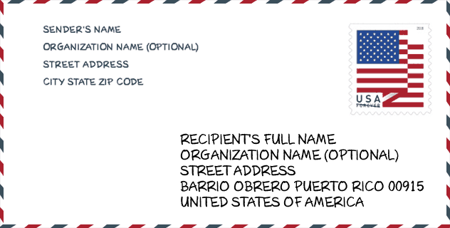
Envelope Example

This is an example of a US zip envelope. You can use a 5-digit zipcode or a detailed 9-digit zipcode to copy the mail in the following address format.
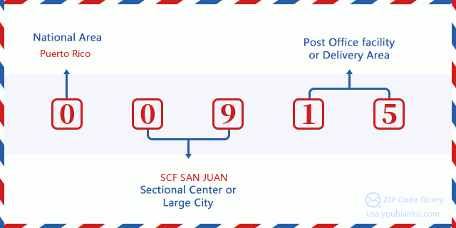
00915 Basic Meaning
What does each digit of ZIP Code 00915 stands for? The first digit designates a national area, which ranges from zero for the Northeast to nine for the far West. The 2-3 digits are the code of a sectional center facility in that region. The last two digits designate small post offices or postal zones.
Online Map

This is online map of the address Sect La Playita, Puerto Rico, United States. You may use button to move and zoom in / out. The map information is for reference only.
Hospital

This is the ZIP Code 00915 - Hospital page list. Its detail Hospital Name, Street, City, State, ZIP Code, Phone is as below.
- Name: METROPOLITAN HOSPITAL
- Address: SAN JUAN
- City: CARRETERA 21 1785 URB LAS LOMAS
- State: PR
- ZIP Code: 00915
- Phone: (787) 782-9999
School

This is the ZIP Code 00915 - School page list. Its detail School Name, Address, City, State, ZIP Code is as below.
| School Name | Address | City | State | Grades | ZIP Code |
|---|---|---|---|---|---|
| FEDERICO ASENJO (PRE-TECNICA) | AVE BORINQUEN 32015 BO OBRERO | SAN JUAN | PR | UG | 00915 |
| ANTONIA B. CAIMARY | AVE EDUARDO CONDE ESQ TAPIA VILLA PALMERAS | SAN JUAN | PR | UG | 00915 |
| MANUEL BOADA | AVE BORINQUEN ESQ CALLE CORTIJO | SAN JUAN | PR | UG | 00915 |
| ALEJANDRO TAPIA Y RIVERA | VILLA PALMERA 369 CALLE BELEVUE | SAN JUAN | PR | UG | 00915 |
| FRAY BARTOLOME DE LAS CASAS | AVE EDUARDO CONDE FINAL | SAN JUAN | PR | UG | 00915 |
| DR. FACUNDO BUESO | CALLE DEL VALLE ESQ EDUARDO CONDE | SAN JUAN | PR | UG | 00915 |
| ALBERT EINSTEIN | CALLE HAYDEE REXACH ESQ BORINQUEN | SAN JUAN | PR | UG | 00915 |
Population for ZIP Code 00915

What is the total population in ZIP Code 00915? Below is detail information.
- Population for ZIP Code 00915: 22,793
- 2010 Population: 32,820
The 2020 demographic statistics are in progress. The current population in ZIP code 00915 is 22,793, and the population in 2010 is 32,820.
Gender

In all the statistical population, the male population is 15,666, the female population is 17,154.
- Male Population: 15,666
- Female Population: 17,154
Race

In all the statistical population, the male population is 15,666, the female population is 17,154.
- White Population: 17,589
- Black Population: 11,724
- Hispanic Population: 32,348
- Asian Population: 295
- Hawaiian Population: 54
- Indian Population: 650
- Other Population: 4,097
Age

In all the statistical population, the White population is 17,589, the Black population is 11,724, the Hispanic population is 32,348, the Asian population is 295, the Hawaiian population is 54, the Indian Ppopulation is 650 and Other population is 4,097.
- Age's Median: 36.8
- Median of male age: 35.2
- Median of female age: 38.5
Households for ZIP Code 00915
ZIP code 00915 has 13,574 households, with an average number of 2.41 persons per household. The average income per household in Zip code 00915 is 13,839 USD, and the average house value is 88,400 USD.
- Households Per Zipcode: 13,574
- Persons Per Household: 2.41
- Average House Value: 88,400
- Income Per Household: 13,839
Geographic

The latitude of the Zip code 00915 is 18.437208, the longitude is -66.044602, and the elevation is 50. It has land area of 1.397 square miles, and water area of 0.314 square miles. The time zone for ZIP code 00915 is Atlantic (GMT -04:00). Daylight saving time should be observed in the area where the zip code is located.
- Latitude: 18.437208
- Longitude: -66.044602
- Elevation: 50
- Land Area: 1.397
- Water Area: 0.314
- Time Zone: Atlantic (GMT -04:00)
- Day Light Saving: N
Delivery

In the ZIP code 00915, there are 9,458 residential delivery mailboxes and centralized units, and 570 commercial delivery mailbox and centralized units, 6,142 single family deliveries and 3,145 multifamily deliveries, and the box count is 10,028. The main post office has city delivery carrier routes for the ZIP code 00915.
- Delivery Residential: 9,458
- Delivery Business: 570
- Delivery Total: 10,028
- Single Family Delivery Units: 6,142
- Multi Family Delivery Units: 3,145
- City Delivery Indicator: Y


Add new comment