ZIP Code: 06457, Middletown, CT
ZIP Code 06457 is located in Middletown, Connecticut. Its detail State, County, City, Longitude, Latitude, Envelope Example, Population is as below.
ZIP Code 06457 Information

-
-
Country:
U.S. - United States
State:
County FIPS:
09007
City:
Area Code:
City Type ?In many cases, a ZIP Code can have multiple "names", meaning cities, towns, or subdivisions, in its boundaries. However, it will ALWAYS have exactly 1 "default" name. D - Default - This is the "preferred" name - by the USPS - for a city. Each ZIP Code has one - and only one - "default" name. In most cases, this is what people who live in that area call the city as well. A - Acceptable - This name can be used for mailing purposes. Often times alternative names are large neighborhoods or sections of the city/town. In some cases a ZIP Code may have several "acceptable" names which is used to group towns under one ZIP Code. N - Not Acceptable - A "not acceptable" name is, in many cases, a nickname that residents give that location. According to the USPS, you should NOT send mail to that ZIP Code using the "not acceptable" name when mailing.:
D (Default)
ZIP Code:
06457
❓What does D (Default) mean? This is the "preferred" name - by the USPS - for a city. Each ZIP Code has one - and only one - "default" name. In most cases, this is what people who live in that area call the city as well.
ZIP Code 06457 Plus 4
ZIP Code 5 plus 4 is the extension of 5-digit zip code, It can be used to locate a more detailed location. The last four digits designate segment or one side of a street or an apartment. You can find the ZIP+4 code and corresponding address of the zip code 06457 below.
| ZIP Code 5 Plus 4 | Address |
|---|---|
| 06457-0001 | PO BOX 1, MIDDLETOWN, CT |
| 06457-0031 | PO BOX 31, MIDDLETOWN, CT |
| 06457-0032 | PO BOX 2201, MIDDLETOWN, CT |
| 06457-0033 | PO BOX 2301, MIDDLETOWN, CT |
| 06457-0034 | PO BOX 2421, MIDDLETOWN, CT |
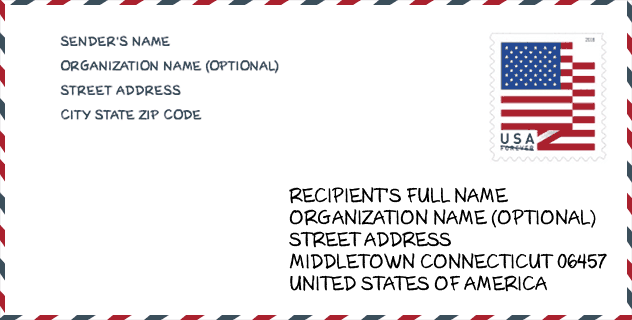
Envelope Example

This is an example of a US zip envelope. You can use a 5-digit zipcode or a detailed 9-digit zipcode to copy the mail in the following address format.
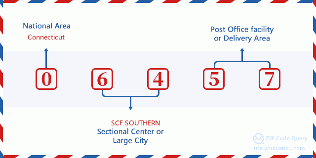
06457 Basic Meaning
What does each digit of ZIP Code 06457 stands for? The first digit designates a national area, which ranges from zero for the Northeast to nine for the far West. The 2-3 digits are the code of a sectional center facility in that region. The last two digits designate small post offices or postal zones.
Online Map

This is online map of the address Middletown, Connecticut, United States. You may use button to move and zoom in / out. The map information is for reference only.
University

This is the ZIP Code 06457 - University page list. Its detail university Name, Street, City, State, ZIP Code, Phone is as below.
| Name | Street | City | State | ZIP Code | Phone |
| Vinal Technical High School | 60 Daniels St | Middletown | CT | 06457 | - |
Hospital

This is the ZIP Code 06457 - Hospital page list. Its detail Hospital Name, Street, City, State, ZIP Code, Phone is as below.
| Name | Address | City | State | ZIP Code | Phone |
|---|---|---|---|---|---|
| ALBERT J SOLNIT CHILDREN'S CENTER - SOUTH CAMPUS | 915 RIVER ROAD | MIDDLETOWN | CT | 06457 | (860) 704-4090 |
| MIDDLESEX HOSPITAL | 28 CRESCENT ST | MIDDLETOWN | CT | 06457 | (860) 344-6000 |
| CONNECTICUT VALLEY HOSP | SILVER ST | MIDDLETOWN | CT | 06457 | (203) 344-2666 |
Museum

This is the ZIP Code 06457 - Museum page list. Its detail Museum Name, Street, City, State, ZIP Code, Phone is as below.
| Name | Street | City | State | ZIP Code | Phone |
| KIDCITY CHILDREN'S MUSEUM | 119 WASHINGTON STREET | MIDDLETOWN | CT | 06457 | (860) 347-0495 |
| PEGAGUS GALLERY | 100 TRAINING HILL RD | MIDDLETOWN | CT | 06457 |
Library

This is the ZIP Code 06457 - Library page list. Its detail Library Name, Address, City, State, ZIP Code, Phone is as below.
- Name: RUSSELL LIBRARY
- Address: 123 BROAD ST.
- City: MIDDLETOWN
- State: CT - Connecticut
- ZIP Code: 06457
- Phone: (860) 347-2528
School
This is the ZIP Code 06457 - School page list. Its detail School Name, Address, City, State, ZIP Code is as below.
- School Name: Middletown High School
- Address: 200 LaRosa Lane
- City: Middletown
- State: CT
- Grades: UG
- ZIP Code: 06457
Population for ZIP Code 06457

What is the total population in ZIP Code 06457? Below is detail information.
- Population for ZIP Code 06457: 45,850
- 2010 Population: 47,648
The 2020 demographic statistics are in progress. The current population in ZIP code 06457 is 45,850, and the population in 2010 is 47,648.
Gender

In all the statistical population, the male population is 23,140, the female population is 24,508.
- Male Population: 23,140
- Female Population: 24,508
Race

In all the statistical population, the male population is 23,140, the female population is 24,508.
- White Population: 37,571
- Black Population: 7,194
- Hispanic Population: 3,949
- Asian Population: 2,735
- Hawaiian Population: 79
- Indian Population: 455
- Other Population: 1,535
Age

In all the statistical population, the White population is 37,571, the Black population is 7,194, the Hispanic population is 3,949, the Asian population is 2,735, the Hawaiian population is 79, the Indian Ppopulation is 455 and Other population is 1,535.
- Age's Median: 37.0
- Median of male age: 35.5
- Median of female age: 38.5
Households for ZIP Code 06457
ZIP code 06457 has 19,863 households, with an average number of 2.21 persons per household. The average income per household in Zip code 06457 is 67,651 USD, and the average house value is 227,000 USD.
- Households Per Zipcode: 19,863
- Persons Per Household: 2.21
- Average House Value: 227,000
- Income Per Household: 67,651
Geographic

The latitude of the Zip code 06457 is 41.549521, the longitude is -72.651825, and the elevation is 89. It has land area of 41.018 square miles, and water area of 1.347 square miles. The time zone for ZIP code 06457 is Eastern (GMT -05:00). Daylight saving time should be observed in the area where the zip code is located.
- Latitude: 41.549521
- Longitude: -72.651825
- Elevation: 89
- Land Area: 41.018
- Water Area: 1.347
- Time Zone: Eastern (GMT -05:00)
- Region: Northeast
- Division: New England
- Day Light Saving: Y
Congressional District

The Congressional District for ZIP code 06457 is Connecticut's 1st|3rd|05th congressional district, the Congressional Land Area is 675.45|470.34|1248.16 square mile.
- Congressional District: 1st|3rd|05th
- Congressional Land Area: 675.45|470.34|1248.16
Delivery

In the ZIP code 06457, there are 20,747 residential delivery mailboxes and centralized units, and 1,234 commercial delivery mailbox and centralized units, 12,828 single family deliveries and 3,327 multifamily deliveries, and the box count is 22,579. The main post office has city delivery carrier routes for the ZIP code 06457.
- Delivery Residential: 20,747
- Delivery Business: 1,234
- Delivery Total: 22,579
- Single Family Delivery Units: 12,828
- Multi Family Delivery Units: 3,327
- City Delivery Indicator: Y
Business

In ZIP code 06457, the number of business is 1,080, the number of employee is 22,710, the business first quarter payroll is 383,903,000 USD, the business annual payroll is 1,480,972,000 USD.
- Number Of Businesses: 1,080
- Number Of Employees: 22,710
- Business First Quarter Payroll: 383,903,000
- Business Annual Payroll: 1,480,972,000


Add new comment