United States ZIP Code: 06515
This is the Connecticut ZIP Code 06515 page list. Its detail State, County, City, Longitude, Latitude, Envelope Example, Population is as below.

ZIP Code 06515 Information

-
-
Country:
U.S. - United States
State:
State FIPS:
09
Area Code:
ZIP Code:
06515
ZIP Type:
S (Standard)
❓What does S (Standard) mean? A "standard" ZIP Code is what most people think of when they talk about ZIP Codes - essentially a town, city, or a division of a city that has mail service.
ZIP Code 06515 - City

This is the city information corresponding to 06515:
| State | County | City | City Type ?In many cases, a ZIP Code can have multiple "names", meaning cities, towns, or subdivisions, in its boundaries. However, it will ALWAYS have exactly 1 "default" name. D - Default - This is the "preferred" name - by the USPS - for a city. Each ZIP Code has one - and only one - "default" name. In most cases, this is what people who live in that area call the city as well. A - Acceptable - This name can be used for mailing purposes. Often times alternative names are large neighborhoods or sections of the city/town. In some cases a ZIP Code may have several "acceptable" names which is used to group towns under one ZIP Code. N - Not Acceptable - A "not acceptable" name is, in many cases, a nickname that residents give that location. According to the USPS, you should NOT send mail to that ZIP Code using the "not acceptable" name when mailing. | ZIP Code |
|---|---|---|---|---|
| CT | New Haven | N Haven | N (Not Acceptable) | 06515 |
| CT | New Haven | New Haven | D (Default) | 06515 |
| CT | New Haven | Westville | N (Not Acceptable) | 06515 |
❓What does D (Default) mean? This is the "preferred" name - by the USPS - for a city. Each ZIP Code has one - and only one - "default" name. In most cases, this is what people who live in that area call the city as well.
❓What does N (Not Acceptable) mean? A "not acceptable" name is, in many cases, a nickname that residents give that location. According to the USPS, you should NOT send mail to that ZIP Code using the "not acceptable" name when mailing.
ZIP Code 06515 Plus 4
ZIP Code 5 plus 4 is the extension of 5-digit zip code, It can be used to locate a more detailed location. The last four digits designate segment or one side of a street or an apartment. You can find the ZIP+4 code and corresponding address of the zip code 06515 below.
| ZIP Code 5 Plus 4 | Address |
|---|---|
| 06515-0001 | PO BOX 2901, NEW HAVEN, CT |
| 06515-0021 | PO BOX 2921, NEW HAVEN, CT |
| 06515-0057 | PO BOX 2957, NEW HAVEN, CT |
| 06515-0061 | PO BOX 2961, NEW HAVEN, CT |
| 06515-0121 | PO BOX 3021, NEW HAVEN, CT |
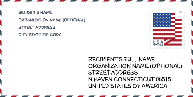
Envelope Example

This is an example of a US zip envelope. You can use a 5-digit zipcode or a detailed 9-digit zipcode to copy the mail in the following address format.
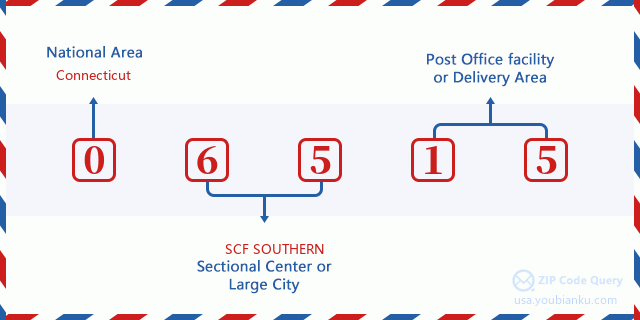
06515 Basic Meaning
What does each digit of ZIP Code 06515 stands for? The first digit designates a national area, which ranges from zero for the Northeast to nine for the far West. The 2-3 digits are the code of a sectional center facility in that region. The last two digits designate small post offices or postal zones.
Online Map

This is online map of the address Westville, Connecticut, United States. You may use button to move and zoom in / out. The map information is for reference only.
Museum

This is the ZIP Code 06515 - Museum page list. Its detail Museum Name, Street, City, State, ZIP Code, Phone is as below.
- Name: WEST ROCK NATURE CENTER
- Street: 720 EDGEWOOD AVENUE
- City: NEW HAVEN
- State: CT
- ZIP Code: 06515
- Phone: (203) 946-6071
Library

This is the ZIP Code 06515 - Library page list. Its detail Library Name, Address, City, State, ZIP Code, Phone is as below.
- Name: MITCHELL BRANCH LIBRARY
- Address: 37 HARRISON STREET
- City: NEW HAVEN
- State: CT - Connecticut
- ZIP Code: 06515
- Phone: (203) 946-8117
School

This is the ZIP Code 06515 - School page list. Its detail School Name, Address, City, State, ZIP Code is as below.
| School Name | Address | City | State | Grades | ZIP Code |
|---|---|---|---|---|---|
| Common Ground High School | 358 Springside Ave. | New Haven | CT | UG | 06515 |
| Elm City Montessori School | 495 Blake Street | New Haven | CT | UG | 06515 |
| Davis Academy for Arts & Design Innovation | 35 Davis St. | New Haven | CT | UG | 06515 |
| Edgewood School | 737 Edgewood Ave. | New Haven | CT | UG | 06515 |
| Barack H. Obama Magnet University School | 69 FARNHAM AVE | New Haven | CT | UG | 06515 |
| Mauro-Sheridan Magnet School | 191 Fountain St. | New Haven | CT | UG | 06515 |
| Brennan Rogers School | 200 Wilmot Rd. | New Haven | CT | UG | 06515 |
Population for ZIP Code 06515

What is the total population in ZIP Code 06515? Below is detail information.
- Population for ZIP Code 06515: 15,803
- 2010 Population: 17,141
The 2020 demographic statistics are in progress. The current population in ZIP code 06515 is 15,803, and the population in 2010 is 17,141.
Gender

In all the statistical population, the male population is 7,775, the female population is 9,366.
- Male Population: 7,775
- Female Population: 9,366
Race

In all the statistical population, the male population is 7,775, the female population is 9,366.
- White Population: 9,204
- Black Population: 6,948
- Hispanic Population: 2,046
- Asian Population: 573
- Hawaiian Population: 27
- Indian Population: 239
- Other Population: 890
Age

In all the statistical population, the White population is 9,204, the Black population is 6,948, the Hispanic population is 2,046, the Asian population is 573, the Hawaiian population is 27, the Indian Ppopulation is 239 and Other population is 890.
- Age's Median: 29.9
- Median of male age: 29.0
- Median of female age: 30.8
Households for ZIP Code 06515
ZIP code 06515 has 6,401 households, with an average number of 2.29 persons per household. The average income per household in Zip code 06515 is 53,928 USD, and the average house value is 217,600 USD.
- Households Per Zipcode: 6,401
- Persons Per Household: 2.29
- Average House Value: 217,600
- Income Per Household: 53,928
Geographic

The latitude of the Zip code 06515 is 41.329074, the longitude is -72.969592, and the elevation is 71. It has land area of 4.558 square miles, and water area of 0.031 square miles. The time zone for ZIP code 06515 is Eastern (GMT -05:00). Daylight saving time should be observed in the area where the zip code is located.
- Latitude: 41.329074
- Longitude: -72.969592
- Elevation: 71
- Land Area: 4.558
- Water Area: 0.031
- Time Zone: Eastern (GMT -05:00)
- Region: Northeast
- Division: New England
- Day Light Saving: Y
Congressional District

The Congressional District for ZIP code 06515 is Connecticut's 3rd congressional district, the Congressional Land Area is 470.34 square mile.
- Congressional District: 3rd
- Congressional Land Area: 470.34
Delivery

In the ZIP code 06515, there are 6,901 residential delivery mailboxes and centralized units, and 311 commercial delivery mailbox and centralized units, 4,514 single family deliveries and 1,833 multifamily deliveries, and the box count is 7,959. The main post office has city delivery carrier routes for the ZIP code 06515.
- Delivery Residential: 6,901
- Delivery Business: 311
- Delivery Total: 7,959
- Single Family Delivery Units: 4,514
- Multi Family Delivery Units: 1,833
- City Delivery Indicator: Y
Business

In ZIP code 06515, the number of business is 232, the number of employee is 2,765, the business first quarter payroll is 22,980,000 USD, the business annual payroll is 96,506,000 USD.
- Number Of Businesses: 232
- Number Of Employees: 2,765
- Business First Quarter Payroll: 22,980,000
- Business Annual Payroll: 96,506,000


Add new comment