United States ZIP Code: 08611
This is the New Jersey ZIP Code 08611 page list. Its detail State, County, City, Longitude, Latitude, Envelope Example, Population is as below.
ZIP Code 08611 Information

-
-
Country:
U.S. - United States
State:
State FIPS:
34
Area Code:
ZIP Code:
08611
ZIP Type:
S (Standard)
❓What does S (Standard) mean? A "standard" ZIP Code is what most people think of when they talk about ZIP Codes - essentially a town, city, or a division of a city that has mail service.
ZIP Code 08611 - City

This is the city information corresponding to 08611:
| State | County | City | City Type ?In many cases, a ZIP Code can have multiple "names", meaning cities, towns, or subdivisions, in its boundaries. However, it will ALWAYS have exactly 1 "default" name. D - Default - This is the "preferred" name - by the USPS - for a city. Each ZIP Code has one - and only one - "default" name. In most cases, this is what people who live in that area call the city as well. A - Acceptable - This name can be used for mailing purposes. Often times alternative names are large neighborhoods or sections of the city/town. In some cases a ZIP Code may have several "acceptable" names which is used to group towns under one ZIP Code. N - Not Acceptable - A "not acceptable" name is, in many cases, a nickname that residents give that location. According to the USPS, you should NOT send mail to that ZIP Code using the "not acceptable" name when mailing. | ZIP Code |
|---|---|---|---|---|
| NJ | Mercer | Hamilton | A (Acceptable) | 08611 |
| NJ | Mercer | Hamilton Township | N (Not Acceptable) | 08611 |
| NJ | Mercer | Hamilton Twp | N (Not Acceptable) | 08611 |
| NJ | Mercer | Trenton | D (Default) | 08611 |
❓What does D (Default) mean? This is the "preferred" name - by the USPS - for a city. Each ZIP Code has one - and only one - "default" name. In most cases, this is what people who live in that area call the city as well.
❓What does A (Acceptable) mean? This name can be used for mailing purposes. Often times alternative names are large neighborhoods or sections of the city/town. In some cases a ZIP Code may have several "acceptable" names which is used to group towns under one ZIP Code.
❓What does N (Not Acceptable) mean? A "not acceptable" name is, in many cases, a nickname that residents give that location. According to the USPS, you should NOT send mail to that ZIP Code using the "not acceptable" name when mailing.
ZIP Code 08611 Plus 4
ZIP Code 5 plus 4 is the extension of 5-digit zip code, It can be used to locate a more detailed location. The last four digits designate segment or one side of a street or an apartment. You can find the ZIP+4 code and corresponding address of the zip code 08611 below.
| ZIP Code 5 Plus 4 | Address |
|---|---|
| 08611-0501 | PO BOX 4501, TRENTON, NJ |
| 08611-1000 | 158 KENT ST #00000003 , TRENTON, NJ |
| 08611-1000 | 158 KENT ST #1F , TRENTON, NJ |
| 08611-1001 | 15 ANDERSON ST, TRENTON, NJ |
| 08611-1002 | 2 ANDERSON ST, TRENTON, NJ |
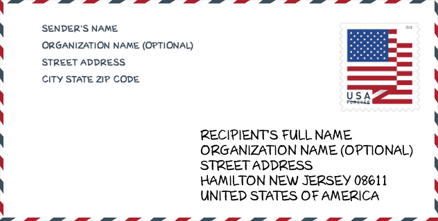
Envelope Example

This is an example of a US zip envelope. You can use a 5-digit zipcode or a detailed 9-digit zipcode to copy the mail in the following address format.
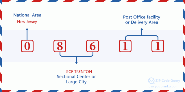
08611 Basic Meaning
What does each digit of ZIP Code 08611 stands for? The first digit designates a national area, which ranges from zero for the Northeast to nine for the far West. The 2-3 digits are the code of a sectional center facility in that region. The last two digits designate small post offices or postal zones.
Online Map

This is online map of the address Trenton, New Jersey, United States. You may use button to move and zoom in / out. The map information is for reference only.
Museum

This is the ZIP Code 08611 - Museum page list. Its detail Museum Name, Street, City, State, ZIP Code, Phone is as below.
- Name: WILLIAM TRENT HOUSE
- Street: 15 MARKET STREET
- City: TRENTON
- State: NJ
- ZIP Code: 08611
- Phone: (609) 989-3027
School

This is the ZIP Code 08611 - School page list. Its detail School Name, Address, City, State, ZIP Code is as below.
| School Name | Address | City | State | Grades | ZIP Code |
|---|---|---|---|---|---|
| Achievers Early College Prep Charter School | 544 CHESTNUT AVE | Trenton | NJ | UG | 08611 |
| Trenton Central High School - Main Campus | 400 CHAMBERS STREET | TRENTON | NJ | UG | 08611 |
| Mott Elementary School | 45 STOKELY AVENUE | TRENTON | NJ | UG | 08611 |
| Washington Elementary School | 331 EMORY AVENUE | TRENTON | NJ | UG | 08611 |
| Harrison Elementary School | 461 GENESSEE STREET | TRENTON | NJ | UG | 08611 |
Population for ZIP Code 08611

What is the total population in ZIP Code 08611? Below is detail information.
- Population for ZIP Code 08611: 26,697
- 2010 Population: 28,038
The 2020 demographic statistics are in progress. The current population in ZIP code 08611 is 26,697, and the population in 2010 is 28,038.
Gender

In all the statistical population, the male population is 15,676, the female population is 12,362.
- Male Population: 15,676
- Female Population: 12,362
Race

In all the statistical population, the male population is 15,676, the female population is 12,362.
- White Population: 11,691
- Black Population: 8,541
- Hispanic Population: 15,191
- Asian Population: 658
- Hawaiian Population: 108
- Indian Population: 498
- Other Population: 8,076
Age

In all the statistical population, the White population is 11,691, the Black population is 8,541, the Hispanic population is 15,191, the Asian population is 658, the Hawaiian population is 108, the Indian Ppopulation is 498 and Other population is 8,076.
- Age's Median: 31.3
- Median of male age: 31.3
- Median of female age: 31.3
Households for ZIP Code 08611
ZIP code 08611 has 8,364 households, with an average number of 3.08 persons per household. The average income per household in Zip code 08611 is 35,720 USD, and the average house value is 89,500 USD.
- Households Per Zipcode: 8,364
- Persons Per Household: 3.08
- Average House Value: 89,500
- Income Per Household: 35,720
Geographic

The latitude of the Zip code 08611 is 40.189898, the longitude is -74.744894, and the elevation is 5. It has land area of 2.631 square miles, and water area of 0.625 square miles. The time zone for ZIP code 08611 is Eastern (GMT -05:00). Daylight saving time should be observed in the area where the zip code is located.
- Latitude: 40.189898
- Longitude: -74.744894
- Elevation: 5
- Land Area: 2.631
- Water Area: 0.625
- Time Zone: Eastern (GMT -05:00)
- Region: Northeast
- Division: Middle Atlantic
- Day Light Saving: Y
Congressional District

The Congressional District for ZIP code 08611 is New Jersey's 04th|12th congressional district, the Congressional Land Area is 691.88|412.23 square mile.
- Congressional District: 04th|12th
- Congressional Land Area: 691.88|412.23
Delivery

In the ZIP code 08611, there are 8,668 residential delivery mailboxes and centralized units, and 601 commercial delivery mailbox and centralized units, 7,290 single family deliveries and 1,107 multifamily deliveries, and the box count is 10,350. The main post office has city delivery carrier routes for the ZIP code 08611.
- Delivery Residential: 8,668
- Delivery Business: 601
- Delivery Total: 10,350
- Single Family Delivery Units: 7,290
- Multi Family Delivery Units: 1,107
- City Delivery Indicator: Y
Business

In ZIP code 08611, the number of business is 376, the number of employee is 4,487, the business first quarter payroll is 36,473,000 USD, the business annual payroll is 151,864,000 USD.
- Number Of Businesses: 376
- Number Of Employees: 4,487
- Business First Quarter Payroll: 36,473,000
- Business Annual Payroll: 151,864,000


Add new comment