United States ZIP Code: 14211
This is the New York ZIP Code 14211 page list. Its detail State, County, City, Longitude, Latitude, Envelope Example, Population is as below.
ZIP Code 14211 Information

-
-
Country:
U.S. - United States
State:
State FIPS:
36
Area Code:
ZIP Code:
14211
ZIP Type:
S (Standard)
❓What does S (Standard) mean? A "standard" ZIP Code is what most people think of when they talk about ZIP Codes - essentially a town, city, or a division of a city that has mail service.
ZIP Code 14211 - City

This is the city information corresponding to 14211:
| State | County | City | City Type ?In many cases, a ZIP Code can have multiple "names", meaning cities, towns, or subdivisions, in its boundaries. However, it will ALWAYS have exactly 1 "default" name. D - Default - This is the "preferred" name - by the USPS - for a city. Each ZIP Code has one - and only one - "default" name. In most cases, this is what people who live in that area call the city as well. A - Acceptable - This name can be used for mailing purposes. Often times alternative names are large neighborhoods or sections of the city/town. In some cases a ZIP Code may have several "acceptable" names which is used to group towns under one ZIP Code. N - Not Acceptable - A "not acceptable" name is, in many cases, a nickname that residents give that location. According to the USPS, you should NOT send mail to that ZIP Code using the "not acceptable" name when mailing. | ZIP Code |
|---|---|---|---|---|
| NY | Erie | Buffalo | D (Default) | 14211 |
| NY | Erie | Cheektowaga | N (Not Acceptable) | 14211 |
❓What does D (Default) mean? This is the "preferred" name - by the USPS - for a city. Each ZIP Code has one - and only one - "default" name. In most cases, this is what people who live in that area call the city as well.
❓What does N (Not Acceptable) mean? A "not acceptable" name is, in many cases, a nickname that residents give that location. According to the USPS, you should NOT send mail to that ZIP Code using the "not acceptable" name when mailing.
ZIP Code 14211 Plus 4
ZIP Code 5 plus 4 is the extension of 5-digit zip code, It can be used to locate a more detailed location. The last four digits designate segment or one side of a street or an apartment. You can find the ZIP+4 code and corresponding address of the zip code 14211 below.
| ZIP Code 5 Plus 4 | Address |
|---|---|
| 14211-1001 | 1 DIGNITY CIR, BUFFALO, NY |
| 14211-1002 | 2 DIGNITY CIR, BUFFALO, NY |
| 14211-1003 | 101 CHELSEA PL, BUFFALO, NY |
| 14211-1004 | 100 CHELSEA PL, BUFFALO, NY |
| 14211-1005 | 481 E DELAVAN AVE, BUFFALO, NY |
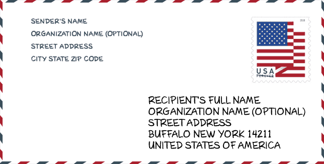
Envelope Example

This is an example of a US zip envelope. You can use a 5-digit zipcode or a detailed 9-digit zipcode to copy the mail in the following address format.
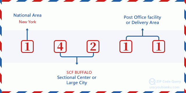
14211 Basic Meaning
What does each digit of ZIP Code 14211 stands for? The first digit designates a national area, which ranges from zero for the Northeast to nine for the far West. The 2-3 digits are the code of a sectional center facility in that region. The last two digits designate small post offices or postal zones.
Online Map

This is online map of the address Cheektowaga, New York, United States. You may use button to move and zoom in / out. The map information is for reference only.
Museum

This is the ZIP Code 14211 - Museum page list. Its detail Museum Name, Street, City, State, ZIP Code, Phone is as below.
- Name: BUFFALO MUSEUM OF SCIENCE
- Street: 1020 HUMBOLDT PARKWAY
- City: BUFFALO
- State: NY
- ZIP Code: 14211
- Phone: (716) 896-5200
School

This is the ZIP Code 14211 - School page list. Its detail School Name, Address, City, State, ZIP Code is as below.
| School Name | Address | City | State | Grades | ZIP Code |
|---|---|---|---|---|---|
| KING CENTER CHARTER SCHOOL | 156 NEWBURGH AVE | BUFFALO | NY | UG | 14211 |
| PERSISTENCE PREPARATORY ACADEMY CHARTER SCHOOL | 378 URBAN ST | BUFFALO | NY | UG | 14211 |
| BUFFALO ACADEMY OF SCIENCE CHARTER SCHOOL II | 335 DOAT ST | BUFFALO | NY | UG | 14211 |
| HARVEY AUSTIN SCHOOL #97 | 1405 SYCAMORE ST | BUFFALO | NY | UG | 14211 |
| EAST COMMUNITY SCHOOL | 820 NORTHAMPTON ST | BUFFALO | NY | UG | 14211 |
| PATHWAYS ACADEMY | 820 NORTHAMPTON ST | BUFFALO | NY | UG | 14211 |
| MARTIN LUTHER KING JR #48 | 487 HIGH ST | BUFFALO | NY | UG | 14211 |
| BUILD COMMUNITY SCHOOL | 340 FERGUSON ST | BUFFALO | NY | UG | 14211 |
Population for ZIP Code 14211

What is the total population in ZIP Code 14211? Below is detail information.
- Population for ZIP Code 14211: 20,377
- 2010 Population: 22,611
The 2020 demographic statistics are in progress. The current population in ZIP code 14211 is 20,377, and the population in 2010 is 22,611.
Gender

In all the statistical population, the male population is 10,275, the female population is 12,336.
- Male Population: 10,275
- Female Population: 12,336
Race

In all the statistical population, the male population is 10,275, the female population is 12,336.
- White Population: 4,244
- Black Population: 17,874
- Hispanic Population: 822
- Asian Population: 588
- Hawaiian Population: 10
- Indian Population: 249
- Other Population: 309
Age

In all the statistical population, the White population is 4,244, the Black population is 17,874, the Hispanic population is 822, the Asian population is 588, the Hawaiian population is 10, the Indian Ppopulation is 249 and Other population is 309.
- Age's Median: 34.1
- Median of male age: 31.4
- Median of female age: 36.2
Households for ZIP Code 14211
ZIP code 14211 has 9,367 households, with an average number of 2.39 persons per household. The average income per household in Zip code 14211 is 26,496 USD, and the average house value is 44,400 USD.
- Households Per Zipcode: 9,367
- Persons Per Household: 2.39
- Average House Value: 44,400
- Income Per Household: 26,496
Geographic

The latitude of the Zip code 14211 is 42.907575, the longitude is -78.819133, and the elevation is 646. It has land area of 4.049 square miles, and water area of 0.007 square miles. The time zone for ZIP code 14211 is Eastern (GMT -05:00). Daylight saving time should be observed in the area where the zip code is located.
- Latitude: 42.907575
- Longitude: -78.819133
- Elevation: 646
- Land Area: 4.049
- Water Area: 0.007
- Time Zone: Eastern (GMT -05:00)
- Region: Northeast
- Division: Middle Atlantic
- Day Light Saving: Y
Congressional District

The Congressional District for ZIP code 14211 is New York's 26th congressional district, the Congressional Land Area is 219.13 square mile.
- Congressional District: 26th
- Congressional Land Area: 219.13
Delivery

In the ZIP code 14211, there are 8,526 residential delivery mailboxes and centralized units, and 466 commercial delivery mailbox and centralized units, 8,270 single family deliveries and 205 multifamily deliveries, and the box count is 8,992. The main post office has city delivery carrier routes for the ZIP code 14211.
- Delivery Residential: 8,526
- Delivery Business: 466
- Delivery Total: 8,992
- Single Family Delivery Units: 8,270
- Multi Family Delivery Units: 205
- City Delivery Indicator: Y
Business

In ZIP code 14211, the number of business is 258, the number of employee is 3,223, the business first quarter payroll is 23,531,000 USD, the business annual payroll is 98,541,000 USD.
- Number Of Businesses: 258
- Number Of Employees: 3,223
- Business First Quarter Payroll: 23,531,000
- Business Annual Payroll: 98,541,000
Social Security Benefits

There are 3,895 beneficiaries with benefits in current-payment status for ZIP code 14211, of which 2,020 are retired workers, 1,120 are disabled workers, 235 are widow(er)s and parents, 50 are spouses and 470 are children. The number of beneficiaries aged 65 or older is 2,170. The total monthly benefits are 4,185,000 USD, of which 2,530,000 USD for retired workers, 269,000 USD for widow(er)s and parents.
- Total Number: 3,895
- Retired workers Number: 2,020
- Disabled workers Number: 1,120
- Widow(er)s and parents Number: 235
- Spouses Number: 50
- Children Number: 470
- All beneficiaries per month: 4,185,000
- Retired workers per month: 2,530,000
- Widow(er)s and parents per month: 269,000
- Number of beneficiaries aged 65 or older: 2,170


Add new comment