ZIP Code: 20019, Washington, DC
ZIP Code 20019 is located in Washington, District of Columbia. Its detail State, County, City, Longitude, Latitude, Envelope Example, Population is as below.
ZIP Code 20019 Information

-
-
Country:
U.S. - United States
County FIPS:
11001
City:
Area Code:
City Type ?In many cases, a ZIP Code can have multiple "names", meaning cities, towns, or subdivisions, in its boundaries. However, it will ALWAYS have exactly 1 "default" name. D - Default - This is the "preferred" name - by the USPS - for a city. Each ZIP Code has one - and only one - "default" name. In most cases, this is what people who live in that area call the city as well. A - Acceptable - This name can be used for mailing purposes. Often times alternative names are large neighborhoods or sections of the city/town. In some cases a ZIP Code may have several "acceptable" names which is used to group towns under one ZIP Code. N - Not Acceptable - A "not acceptable" name is, in many cases, a nickname that residents give that location. According to the USPS, you should NOT send mail to that ZIP Code using the "not acceptable" name when mailing.:
D (Default)
ZIP Code:
20019
❓What does D (Default) mean? This is the "preferred" name - by the USPS - for a city. Each ZIP Code has one - and only one - "default" name. In most cases, this is what people who live in that area call the city as well.
ZIP Code 20019 Plus 4
ZIP Code 5 plus 4 is the extension of 5-digit zip code, It can be used to locate a more detailed location. The last four digits designate segment or one side of a street or an apartment. You can find the ZIP+4 code and corresponding address of the zip code 20019 below.
| ZIP Code 5 Plus 4 | Address |
|---|---|
| 20019-1000 | 2500 N ST, WASHINGTON, DC |
| 20019-1002 | 2701 FAIRLAWN AVE, WASHINGTON, DC |
| 20019-1003 | 2727 FAIRLAWN AVE #00000100 , WASHINGTON, DC |
| 20019-1004 | 2700 MINNESOTA AVE, WASHINGTON, DC |
| 20019-1005 | 2701 MINNESOTA AVE, WASHINGTON, DC |
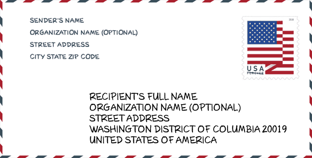
Envelope Example

This is an example of a US zip envelope. You can use a 5-digit zipcode or a detailed 9-digit zipcode to copy the mail in the following address format.
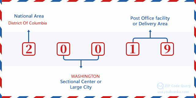
20019 Basic Meaning
What does each digit of ZIP Code 20019 stands for? The first digit designates a national area, which ranges from zero for the Northeast to nine for the far West. The 2-3 digits are the code of a sectional center facility in that region. The last two digits designate small post offices or postal zones.
Online Map

This is online map of the address Washington, District of Columbia, United States. You may use button to move and zoom in / out. The map information is for reference only.
Library

This is the ZIP Code 20019 - Library page list. Its detail Library Name, Address, City, State, ZIP Code, Phone is as below.
| Name | Address | City | State | ZIP Code | Phone |
|---|---|---|---|---|---|
| CAPITOL VIEW BRANCH LIBRARY | 5001 CENTRAL AVENUE, SE | WASHINGTON | DC | 20019 | (202) 645-0755 |
| DEANWOOD NEIGHBORHOOD LIBRARY | 1350 49TH STREET, NE | WASHINGTON | DC | 20019 | (202) 698-1175 |
| DOROTHY I. HEIGHT & BENNING LIBRARY | 3935 BENNING ROAD, NE | WASHINGTON | DC | 20019 | (202) 281-2583 |
School

This is the ZIP Code 20019 - School page list. Its detail School Name, Address, City, State, ZIP Code is as below.
| School Name | Address | City | State | Grades | ZIP Code |
|---|---|---|---|---|---|
| Cesar Chavez Public Charter Schools for Public Policy | 3701 HAYES STREET NE | Washington | DC | UG | 20019 |
| Friendship PCS - Collegiate Academy | 4095 MINNESOTA AVENUE NE | Washington | DC | UG | 20019 |
| Elsie Whitlow Stokes Community Freedom PCS - East End | 5600 EAST CAPITOL STREET NE | Washington | DC | UG | 20019 |
| IDEA PCS | 1027 45TH STREET NE | Washington | DC | UG | 20019 |
| Maya Angelou PCS - HS | 5600 EAST CAPITOL STREET NE | Washington | DC | UG | 20019 |
| SEED PCS of Washington DC | 4300 C STREET SE | Washington | DC | UG | 20019 |
| Sousa MS | 3650 ELY PL. SE | Washington | DC | UG | 20019 |
| Thomas ES | 650 ANACOSTIA AVE. NE | Washington | DC | UG | 20019 |
| H.D. Woodson HS | 540 55TH ST. NE | Washington | DC | UG | 20019 |
| Smothers ES | 1300 44TH ST. NE | Washington | DC | UG | 20019 |
| Drew ES | 5600 EADS ST. NE | Washington | DC | UG | 20019 |
| Burrville ES | 801 DIVISION AVE. NE | Washington | DC | UG | 20019 |
| Aiton ES | 533 48TH PL. NE | Washington | DC | UG | 20019 |
| Plummer ES | 4601 TEXAS AVE. SE | Washington | DC | UG | 20019 |
| Nalle ES | 219 50TH ST. SE | Washington | DC | UG | 20019 |
| Kimball ES | 3375 MINNESOTA AVE. SE | Washington | DC | UG | 20019 |
| Houston ES | 1100 50TH PL. NE | Washington | DC | UG | 20019 |
| C.W. Harris ES | 301 53RD ST. SE | Washington | DC | UG | 20019 |
| Kelly Miller MS | 301 49TH ST. NE | Washington | DC | UG | 20019 |
| River Terrace Education Campus | 405 ANACOSTIA AVE. NE | Washington | DC | UG | 20019 |
| Ron Brown College Preparatory HS | 4800 MEADE ST. NE | Washington | DC | UG | 20019 |
| Bard HS Early College DC (Bard DC) | 4430 H ST. SE | Washington | DC | UG | 20019 |
| KIPP DC - KEY Academy PCS | 4801 BENNING ROAD SE | Washington | DC | UG | 20019 |
| KIPP DC - LEAP Academy PCS | 4801 BENNING ROAD SE | Washington | DC | UG | 20019 |
| KIPP DC - Promise Academy PCS | 4801 BENNING ROAD SE | Washington | DC | UG | 20019 |
| KIPP DC - Valor Academy PCS | 5300 BLAINE STREET NE | Washington | DC | UG | 20019 |
| KIPP DC - Quest Academy PCS | 5300 BLAINE STREET NE | Washington | DC | UG | 20019 |
| KIPP DC - Arts and Technology Academy PCS | 5300 BLAINE STREET NE | Washington | DC | UG | 20019 |
| DC Prep PCS - Benning ES | 100 41ST STREET NE | Washington | DC | UG | 20019 |
| DC Prep PCS - Benning MS | 100 41ST STREET NE | Washington | DC | UG | 20019 |
| DC Scholars PCS | 5601 EAST CAPITOL STREET SE | Washington | DC | UG | 20019 |
| Rocketship PCS - Legacy Prep | 4250 MASSACHUSETTS AVENUE SE | Washington | DC | UG | 20019 |
| Global Citizens PCS | 4095 MINNESOTA AVENUE NE | Washington | DC | UG | 20019 |
Population for ZIP Code 20019

What is the total population in ZIP Code 20019? Below is detail information.
- Population for ZIP Code 20019: 57,591
- 2010 Population: 54,358
The 2020 demographic statistics are in progress. The current population in ZIP code 20019 is 57,591, and the population in 2010 is 54,358.
Gender

In all the statistical population, the male population is 24,004, the female population is 30,354.
- Male Population: 24,004
- Female Population: 30,354
Race

In all the statistical population, the male population is 24,004, the female population is 30,354.
- White Population: 1,020
- Black Population: 52,789
- Hispanic Population: 1,312
- Asian Population: 190
- Hawaiian Population: 56
- Indian Population: 583
- Other Population: 809
Age

In all the statistical population, the White population is 1,020, the Black population is 52,789, the Hispanic population is 1,312, the Asian population is 190, the Hawaiian population is 56, the Indian Ppopulation is 583 and Other population is 809.
- Age's Median: 35.0
- Median of male age: 31.5
- Median of female age: 37.6
Households for ZIP Code 20019
ZIP code 20019 has 22,076 households, with an average number of 2.44 persons per household. The average income per household in Zip code 20019 is 36,398 USD, and the average house value is 275,600 USD.
- Households Per Zipcode: 22,076
- Persons Per Household: 2.44
- Average House Value: 275,600
- Income Per Household: 36,398
Housing Unit

In ZIP code 20019, the growth rank of housing unit is 75, the number of housing unit was 601,723 in 2010 and increased to 617,996 in 2011, the growth increase number is 16,273, the growth increase percentage is 2.7%.
- Growth Rank: 75
- Housing Units Estimate in 2010: 601,723
- Housing Units Estimate in 2011: 617,996
- Growth Increase Number: 16,273
- Growth Increase Percentage: 2.7%
Geographic

The latitude of the Zip code 20019 is 38.892782, the longitude is -76.940510, and the elevation is 78. It has land area of 6.261 square miles, and water area of 0.213 square miles. The time zone for ZIP code 20019 is Eastern (GMT -05:00). Daylight saving time should be observed in the area where the zip code is located.
- Latitude: 38.892782
- Longitude: -76.940510
- Elevation: 78
- Land Area: 6.261
- Water Area: 0.213
- Time Zone: Eastern (GMT -05:00)
- Region: South
- Division: South Atlantic
- Day Light Saving: Y
Congressional District

The Congressional District for ZIP code 20019 is District of Columbia's 98th congressional district, the Congressional Land Area is 61.40 square mile.
- Congressional District: 98th
- Congressional Land Area: 61.40
Delivery

In the ZIP code 20019, there are 23,603 residential delivery mailboxes and centralized units, and 531 commercial delivery mailbox and centralized units, 10,770 single family deliveries and 9,293 multifamily deliveries, and the box count is 25,407. The main post office has city delivery carrier routes for the ZIP code 20019.
- Delivery Residential: 23,603
- Delivery Business: 531
- Delivery Total: 25,407
- Single Family Delivery Units: 10,770
- Multi Family Delivery Units: 9,293
- City Delivery Indicator: Y
Business

In ZIP code 20019, the number of business is 392, the number of employee is 6,585, the business first quarter payroll is 80,310,000 USD, the business annual payroll is 317,969,000 USD.
- Number Of Businesses: 392
- Number Of Employees: 6,585
- Business First Quarter Payroll: 80,310,000
- Business Annual Payroll: 317,969,000
Social Security Benefits

There are 9,500 beneficiaries with benefits in current-payment status for ZIP code 20019, of which 5,620 are retired workers, 2,380 are disabled workers, 505 are widow(er)s and parents, 95 are spouses and 900 are children. The number of beneficiaries aged 65 or older is 5,810. The total monthly benefits are 9,895,000 USD, of which 6,173,000 USD for retired workers, 512,000 USD for widow(er)s and parents.
- Total Number: 9,500
- Retired workers Number: 5,620
- Disabled workers Number: 2,380
- Widow(er)s and parents Number: 505
- Spouses Number: 95
- Children Number: 900
- All beneficiaries per month: 9,895,000
- Retired workers per month: 6,173,000
- Widow(er)s and parents per month: 512,000
- Number of beneficiaries aged 65 or older: 5,810


Add new comment