United States ZIP Code: 29061
This is the South Carolina ZIP Code 29061 page list. Its detail State, County, City, Longitude, Latitude, Envelope Example, Population is as below.

ZIP Code 29061 Information

-
-
Country:
U.S. - United States
State:
State FIPS:
45
Area Code:
ZIP Code:
29061
ZIP Type:
S (Standard)
❓What does S (Standard) mean? A "standard" ZIP Code is what most people think of when they talk about ZIP Codes - essentially a town, city, or a division of a city that has mail service.
ZIP Code 29061 - City

This is the city information corresponding to 29061:
| State | County | City | City Type ?In many cases, a ZIP Code can have multiple "names", meaning cities, towns, or subdivisions, in its boundaries. However, it will ALWAYS have exactly 1 "default" name. D - Default - This is the "preferred" name - by the USPS - for a city. Each ZIP Code has one - and only one - "default" name. In most cases, this is what people who live in that area call the city as well. A - Acceptable - This name can be used for mailing purposes. Often times alternative names are large neighborhoods or sections of the city/town. In some cases a ZIP Code may have several "acceptable" names which is used to group towns under one ZIP Code. N - Not Acceptable - A "not acceptable" name is, in many cases, a nickname that residents give that location. According to the USPS, you should NOT send mail to that ZIP Code using the "not acceptable" name when mailing. | ZIP Code |
|---|---|---|---|---|
| SC | Richland | Hopkins | D (Default) | 29061 |
| SC | Richland | Horrel Hill | N (Not Acceptable) | 29061 |
❓What does D (Default) mean? This is the "preferred" name - by the USPS - for a city. Each ZIP Code has one - and only one - "default" name. In most cases, this is what people who live in that area call the city as well.
❓What does N (Not Acceptable) mean? A "not acceptable" name is, in many cases, a nickname that residents give that location. According to the USPS, you should NOT send mail to that ZIP Code using the "not acceptable" name when mailing.
ZIP Code 29061 Plus 4
ZIP Code 5 plus 4 is the extension of 5-digit zip code, It can be used to locate a more detailed location. The last four digits designate segment or one side of a street or an apartment. You can find the ZIP+4 code and corresponding address of the zip code 29061 below.
| ZIP Code 5 Plus 4 | Address |
|---|---|
| 29061-0001 | PO BOX 1, HOPKINS, SC |
| 29061-0121 | PO BOX 121, HOPKINS, SC |
| 29061-0221 | PO BOX 221, HOPKINS, SC |
| 29061-0321 | PO BOX 321, HOPKINS, SC |
| 29061-0381 | PO BOX 381, HOPKINS, SC |
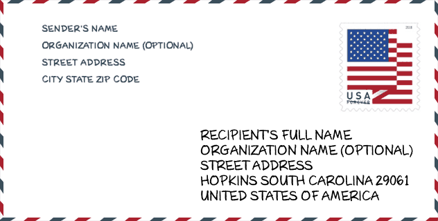
Envelope Example

This is an example of a US zip envelope. You can use a 5-digit zipcode or a detailed 9-digit zipcode to copy the mail in the following address format.
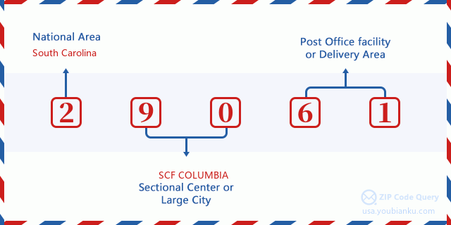
29061 Basic Meaning
What does each digit of ZIP Code 29061 stands for? The first digit designates a national area, which ranges from zero for the Northeast to nine for the far West. The 2-3 digits are the code of a sectional center facility in that region. The last two digits designate small post offices or postal zones.
Online Map

This is online map of the address Horrel Hill, South Carolina, United States. You may use button to move and zoom in / out. The map information is for reference only.
Museum

This is the ZIP Code 29061 - Museum page list. Its detail Museum Name, Street, City, State, ZIP Code, Phone is as below.
- Name: CONGAREE NATIONAL PARK
- Street: 100 NATIONAL PARK ROAD
- City: HOPKINS
- State: SC
- ZIP Code: 29061
- Phone: (803) 647-3974
School

This is the ZIP Code 29061 - School page list. Its detail School Name, Address, City, State, ZIP Code is as below.
| School Name | Address | City | State | Grades | ZIP Code |
|---|---|---|---|---|---|
| Southeast Middle | 731 Horrell Hill Road | Hopkins | SC | UG | 29061 |
| Hopkins Elementary | 6120 Cabin Creek Road | Hopkins | SC | UG | 29061 |
| Horrell Hill Elementary | 517 Horrell Hill Road | Hopkins | SC | UG | 29061 |
| Lower Richland High | 2615 Lower Richland Boulevard | Hopkins | SC | UG | 29061 |
| Hopkins Middle | 1601 Clarkson Road | Hopkins | SC | UG | 29061 |
Population for ZIP Code 29061

What is the total population in ZIP Code 29061? Below is detail information.
- Population for ZIP Code 29061: 15,579
- 2010 Population: 13,717
The 2020 demographic statistics are in progress. The current population in ZIP code 29061 is 15,579, and the population in 2010 is 13,717.
Gender

In all the statistical population, the male population is 6,560, the female population is 7,157.
- Male Population: 6,560
- Female Population: 7,157
Race

In all the statistical population, the male population is 6,560, the female population is 7,157.
- White Population: 4,375
- Black Population: 9,068
- Hispanic Population: 555
- Asian Population: 141
- Hawaiian Population: 20
- Indian Population: 101
- Other Population: 321
Age

In all the statistical population, the White population is 4,375, the Black population is 9,068, the Hispanic population is 555, the Asian population is 141, the Hawaiian population is 20, the Indian Ppopulation is 101 and Other population is 321.
- Age's Median: 38.4
- Median of male age: 37.2
- Median of female age: 39.4
Households for ZIP Code 29061
ZIP code 29061 has 5,136 households, with an average number of 2.66 persons per household. The average income per household in Zip code 29061 is 53,317 USD, and the average house value is 114,500 USD.
- Households Per Zipcode: 5,136
- Persons Per Household: 2.66
- Average House Value: 114,500
- Income Per Household: 53,317
Geographic

The latitude of the Zip code 29061 is 33.881494, the longitude is -80.847488, and the elevation is 169. It has land area of 89.021 square miles, and water area of 1.468 square miles. The time zone for ZIP code 29061 is Eastern (GMT -05:00). Daylight saving time should be observed in the area where the zip code is located.
- Latitude: 33.881494
- Longitude: -80.847488
- Elevation: 169
- Land Area: 89.021
- Water Area: 1.468
- Time Zone: Eastern (GMT -05:00)
- Region: South
- Division: South Atlantic
- Day Light Saving: Y
Congressional District

The Congressional District for ZIP code 29061 is South Carolina's 2nd|06th congressional district, the Congressional Land Area is 3022.17|8062.93 square mile.
- Congressional District: 2nd|06th
- Congressional Land Area: 3022.17|8062.93
Delivery

In the ZIP code 29061, there are 5,857 residential delivery mailboxes and centralized units, and 158 commercial delivery mailbox and centralized units, 5,738 single family deliveries and 0 multifamily deliveries, and the box count is 6,250. The main post office does not have city delivery carrier routes for the ZIP code 29061.
- Delivery Residential: 5,857
- Delivery Business: 158
- Delivery Total: 6,250
- Single Family Delivery Units: 5,738
- Multi Family Delivery Units: 0
- City Delivery Indicator: N
Business

In ZIP code 29061, the number of business is 88, the number of employee is 2,185, the business first quarter payroll is 35,622,000 USD, the business annual payroll is 146,085,000 USD.
- Number Of Businesses: 88
- Number Of Employees: 2,185
- Business First Quarter Payroll: 35,622,000
- Business Annual Payroll: 146,085,000
Social Security Benefits

There are 3,250 beneficiaries with benefits in current-payment status for ZIP code 29061, of which 2,115 are retired workers, 590 are disabled workers, 190 are widow(er)s and parents, 65 are spouses and 290 are children. The number of beneficiaries aged 65 or older is 2,155. The total monthly benefits are 4,180,000 USD, of which 2,943,000 USD for retired workers, 228,000 USD for widow(er)s and parents.
- Total Number: 3,250
- Retired workers Number: 2,115
- Disabled workers Number: 590
- Widow(er)s and parents Number: 190
- Spouses Number: 65
- Children Number: 290
- All beneficiaries per month: 4,180,000
- Retired workers per month: 2,943,000
- Widow(er)s and parents per month: 228,000
- Number of beneficiaries aged 65 or older: 2,155


Add new comment