United States ZIP Code: 30360
This is the Georgia ZIP Code 30360 page list. Its detail State, County, City, Longitude, Latitude, Envelope Example, Population is as below.

ZIP Code 30360 Information

-
-
Country:
U.S. - United States
State:
State FIPS:
13
ZIP Code:
30360
ZIP Type:
S (Standard)
❓What does S (Standard) mean? A "standard" ZIP Code is what most people think of when they talk about ZIP Codes - essentially a town, city, or a division of a city that has mail service.
ZIP Code 30360 - City

This is the city information corresponding to 30360:
| State | County | City | City Type ?In many cases, a ZIP Code can have multiple "names", meaning cities, towns, or subdivisions, in its boundaries. However, it will ALWAYS have exactly 1 "default" name. D - Default - This is the "preferred" name - by the USPS - for a city. Each ZIP Code has one - and only one - "default" name. In most cases, this is what people who live in that area call the city as well. A - Acceptable - This name can be used for mailing purposes. Often times alternative names are large neighborhoods or sections of the city/town. In some cases a ZIP Code may have several "acceptable" names which is used to group towns under one ZIP Code. N - Not Acceptable - A "not acceptable" name is, in many cases, a nickname that residents give that location. According to the USPS, you should NOT send mail to that ZIP Code using the "not acceptable" name when mailing. | ZIP Code |
|---|---|---|---|---|
| GA | Dekalb | Atl | N (Not Acceptable) | 30360 |
| GA | Dekalb | Atlanta | D (Default) | 30360 |
| GA | Dekalb | Doraville | A (Acceptable) | 30360 |
| GA | Dekalb | Dunwoody | A (Acceptable) | 30360 |
| GA | Dekalb | Winters Chapel | N (Not Acceptable) | 30360 |
❓What does D (Default) mean? This is the "preferred" name - by the USPS - for a city. Each ZIP Code has one - and only one - "default" name. In most cases, this is what people who live in that area call the city as well.
❓What does A (Acceptable) mean? This name can be used for mailing purposes. Often times alternative names are large neighborhoods or sections of the city/town. In some cases a ZIP Code may have several "acceptable" names which is used to group towns under one ZIP Code.
❓What does N (Not Acceptable) mean? A "not acceptable" name is, in many cases, a nickname that residents give that location. According to the USPS, you should NOT send mail to that ZIP Code using the "not acceptable" name when mailing.
ZIP Code 30360 Plus 4
ZIP Code 5 plus 4 is the extension of 5-digit zip code, It can be used to locate a more detailed location. The last four digits designate segment or one side of a street or an apartment. You can find the ZIP+4 code and corresponding address of the zip code 30360 below.
| ZIP Code 5 Plus 4 | Address |
|---|---|
| 30360-1200 | 5200 ASHLEY TRCE, ATLANTA, GA |
| 30360-1201 | 5201 FLEUR DE LIS CT, ATLANTA, GA |
| 30360-1202 | 5200 FLEUR DE LIS CT, ATLANTA, GA |
| 30360-1203 | 2701 FLEUR DE LIS WAY, ATLANTA, GA |
| 30360-1204 | 2700 FLEUR DE LIS WAY, ATLANTA, GA |
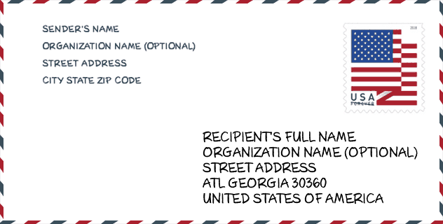
Envelope Example

This is an example of a US zip envelope. You can use a 5-digit zipcode or a detailed 9-digit zipcode to copy the mail in the following address format.
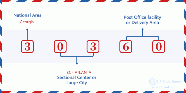
30360 Basic Meaning
What does each digit of ZIP Code 30360 stands for? The first digit designates a national area, which ranges from zero for the Northeast to nine for the far West. The 2-3 digits are the code of a sectional center facility in that region. The last two digits designate small post offices or postal zones.
Online Map

This is online map of the address Winters Chapel, Georgia, United States. You may use button to move and zoom in / out. The map information is for reference only.
University

This is the ZIP Code 30360 - University page list. Its detail university Name, Street, City, State, ZIP Code, Phone is as below.
| Name | Street | City | State | ZIP Code | Phone |
| Georgia Christian University | 6789 Peachtree Industrial Boulevard | Atlanta | GA | 30360 | - |
School
This is the ZIP Code 30360 - School page list. Its detail School Name, Address, City, State, ZIP Code is as below.
- School Name: Hightower Elementary School
- Address: 4236 Tilly Mill Rd
- City: Doraville
- State: GA
- Grades: UG
- ZIP Code: 30360
Population for ZIP Code 30360

What is the total population in ZIP Code 30360? Below is detail information.
- Population for ZIP Code 30360: 17,844
- 2010 Population: 14,536
The 2020 demographic statistics are in progress. The current population in ZIP code 30360 is 17,844, and the population in 2010 is 14,536.
Gender

In all the statistical population, the male population is 7,704, the female population is 6,832.
- Male Population: 7,704
- Female Population: 6,832
Race

In all the statistical population, the male population is 7,704, the female population is 6,832.
- White Population: 9,001
- Black Population: 1,776
- Hispanic Population: 5,726
- Asian Population: 1,214
- Hawaiian Population: 67
- Indian Population: 194
- Other Population: 2,862
Age

In all the statistical population, the White population is 9,001, the Black population is 1,776, the Hispanic population is 5,726, the Asian population is 1,214, the Hawaiian population is 67, the Indian Ppopulation is 194 and Other population is 2,862.
- Age's Median: 32.8
- Median of male age: 32.1
- Median of female age: 33.8
Households for ZIP Code 30360
ZIP code 30360 has 5,049 households, with an average number of 2.88 persons per household. The average income per household in Zip code 30360 is 70,063 USD, and the average house value is 281,300 USD.
- Households Per Zipcode: 5,049
- Persons Per Household: 2.88
- Average House Value: 281,300
- Income Per Household: 70,063
Geographic

The latitude of the Zip code 30360 is 33.933808, the longitude is -84.266200, and the elevation is 1040. It has land area of 5.835 square miles, and water area of 0.151 square miles. The time zone for ZIP code 30360 is Eastern (GMT -05:00). Daylight saving time should be observed in the area where the zip code is located.
- Latitude: 33.933808
- Longitude: -84.266200
- Elevation: 1040
- Land Area: 5.835
- Water Area: 0.151
- Time Zone: Eastern (GMT -05:00)
- Region: South
- Division: South Atlantic
- Day Light Saving: Y
Congressional District

The Congressional District for ZIP code 30360 is Georgia's 06th|07th congressional district, the Congressional Land Area is 298.76|392.61 square mile.
- Congressional District: 06th|07th
- Congressional Land Area: 298.76|392.61
Delivery

In the ZIP code 30360, there are 6,196 residential delivery mailboxes and centralized units, and 503 commercial delivery mailbox and centralized units, 3,478 single family deliveries and 2,064 multifamily deliveries, and the box count is 6,673. The main post office has city delivery carrier routes for the ZIP code 30360.
- Delivery Residential: 6,196
- Delivery Business: 503
- Delivery Total: 6,673
- Single Family Delivery Units: 3,478
- Multi Family Delivery Units: 2,064
- City Delivery Indicator: Y
Business

In ZIP code 30360, the number of business is 461, the number of employee is 5,573, the business first quarter payroll is 57,492,000 USD, the business annual payroll is 242,136,000 USD.
- Number Of Businesses: 461
- Number Of Employees: 5,573
- Business First Quarter Payroll: 57,492,000
- Business Annual Payroll: 242,136,000
Social Security Benefits

There are 1,580 beneficiaries with benefits in current-payment status for ZIP code 30360, of which 1,205 are retired workers, 130 are disabled workers, 95 are widow(er)s and parents, 75 are spouses and 75 are children. The number of beneficiaries aged 65 or older is 1,315. The total monthly benefits are 2,398,000 USD, of which 1,947,000 USD for retired workers, 146,000 USD for widow(er)s and parents.
- Total Number: 1,580
- Retired workers Number: 1,205
- Disabled workers Number: 130
- Widow(er)s and parents Number: 95
- Spouses Number: 75
- Children Number: 75
- All beneficiaries per month: 2,398,000
- Retired workers per month: 1,947,000
- Widow(er)s and parents per month: 146,000
- Number of beneficiaries aged 65 or older: 1,315


Add new comment