ZIP Code: 30528, Cleveland, GA
ZIP Code 30528 is located in Cleveland, Georgia. Its detail State, County, City, Longitude, Latitude, Envelope Example, Population is as below.

ZIP Code 30528 Information

-
-
Country:
U.S. - United States
State:
County FIPS:
13311
County:
City:
City Type ?In many cases, a ZIP Code can have multiple "names", meaning cities, towns, or subdivisions, in its boundaries. However, it will ALWAYS have exactly 1 "default" name. D - Default - This is the "preferred" name - by the USPS - for a city. Each ZIP Code has one - and only one - "default" name. In most cases, this is what people who live in that area call the city as well. A - Acceptable - This name can be used for mailing purposes. Often times alternative names are large neighborhoods or sections of the city/town. In some cases a ZIP Code may have several "acceptable" names which is used to group towns under one ZIP Code. N - Not Acceptable - A "not acceptable" name is, in many cases, a nickname that residents give that location. According to the USPS, you should NOT send mail to that ZIP Code using the "not acceptable" name when mailing.:
D (Default)
ZIP Code:
30528
❓What does D (Default) mean? This is the "preferred" name - by the USPS - for a city. Each ZIP Code has one - and only one - "default" name. In most cases, this is what people who live in that area call the city as well.
ZIP Code 30528 Plus 4
ZIP Code 5 plus 4 is the extension of 5-digit zip code, It can be used to locate a more detailed location. The last four digits designate segment or one side of a street or an apartment. You can find the ZIP+4 code and corresponding address of the zip code 30528 below.
| ZIP Code 5 Plus 4 | Address |
|---|---|
| 30528-8001 | 15107 HIGHWAY 19, CLEVELAND, GA |
| 30528-8002 | 15220 HIGHWAY 19, CLEVELAND, GA |
| 30528-8003 | 15220 HIGHWAY 19 #00000005 , CLEVELAND, GA |
| 30528-8003 | 15220 HIGHWAY 19 #00000027 , CLEVELAND, GA |
| 30528-8003 | 15220 HIGHWAY 19 #00000022 , CLEVELAND, GA |
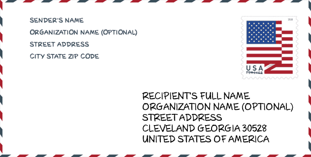
Envelope Example

This is an example of a US zip envelope. You can use a 5-digit zipcode or a detailed 9-digit zipcode to copy the mail in the following address format.
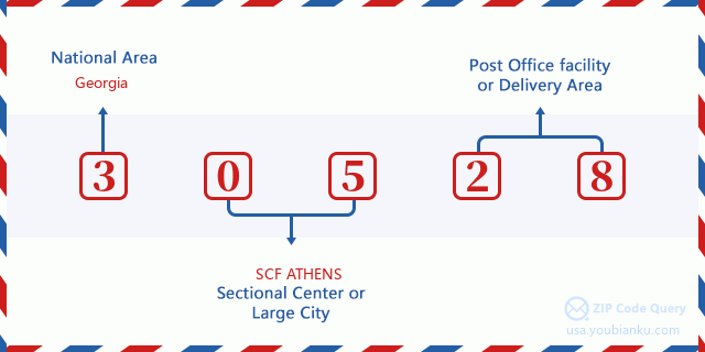
30528 Basic Meaning
What does each digit of ZIP Code 30528 stands for? The first digit designates a national area, which ranges from zero for the Northeast to nine for the far West. The 2-3 digits are the code of a sectional center facility in that region. The last two digits designate small post offices or postal zones.
Online Map

This is online map of the address Cleveland, Georgia, United States. You may use button to move and zoom in / out. The map information is for reference only.
University

This is the ZIP Code 30528 - University page list. Its detail university Name, Street, City, State, ZIP Code, Phone is as below.
| Name | Street | City | State | ZIP Code | Phone |
| Truett-McConnell College | 100 Alumni Dr | Cleveland | GA | 30528 | - |
| Truett McConnell University | 100 Alumni Dr | Cleveland | GA | 30528 | (706) 865-2134 |
Library

This is the ZIP Code 30528 - Library page list. Its detail Library Name, Address, City, State, ZIP Code, Phone is as below.
- Name: WHITE COUNTY PUBLIC LIBRARY-CLEVELAND BRANCH
- Address: 10 COLONIAL DRIVE
- City: CLEVELAND
- State: GA - Georgia
- ZIP Code: 30528
- Phone: (706) 865-5572
School
This is the ZIP Code 30528 - School page list. Its detail School Name, Address, City, State, ZIP Code is as below.
| School Name | Address | City | State | Grades | ZIP Code |
|---|---|---|---|---|---|
| Mountain Education Charter High School | 1963 Tom Bell Rd | Cleveland | GA | UG | 30528 |
| White County Middle School | 283 Old Blairsville Rd | Cleveland | GA | UG | 30528 |
| White County High School | 2600 Highway 129 N | Cleveland | GA | UG | 30528 |
| Tesnatee Gap Elementary (Old White Co. Intermediate) | 2696 Tesnatee Gap Valley Rd | Cleveland | GA | UG | 30528 |
| Jack P Nix Elementary School | 342 W Kytle St | Cleveland | GA | UG | 30528 |
| Mossy Creek Elementary School | 128 Horace Fitzpatrick Dr | Cleveland | GA | UG | 30528 |
Population for ZIP Code 30528

What is the total population in ZIP Code 30528? Below is detail information.
- Population for ZIP Code 30528: 23,398
- 2010 Population: 22,679
The 2020 demographic statistics are in progress. The current population in ZIP code 30528 is 23,398, and the population in 2010 is 22,679.
Gender

In all the statistical population, the male population is 11,052, the female population is 11,627.
- Male Population: 11,052
- Female Population: 11,627
Race

In all the statistical population, the male population is 11,052, the female population is 11,627.
- White Population: 21,856
- Black Population: 477
- Hispanic Population: 578
- Asian Population: 109
- Hawaiian Population: 19
- Indian Population: 284
- Other Population: 263
Age

In all the statistical population, the White population is 21,856, the Black population is 477, the Hispanic population is 578, the Asian population is 109, the Hawaiian population is 19, the Indian Ppopulation is 284 and Other population is 263.
- Age's Median: 40.4
- Median of male age: 39.2
- Median of female age: 41.6
Households for ZIP Code 30528
ZIP code 30528 has 8,721 households, with an average number of 2.56 persons per household. The average income per household in Zip code 30528 is 45,474 USD, and the average house value is 157,500 USD.
- Households Per Zipcode: 8,721
- Persons Per Household: 2.56
- Average House Value: 157,500
- Income Per Household: 45,474
Geographic

The latitude of the Zip code 30528 is 34.617535, the longitude is -83.775948, and the elevation is 1550. It has land area of 178.464 square miles, and water area of 1.09 square miles. The time zone for ZIP code 30528 is Eastern (GMT -05:00). Daylight saving time should be observed in the area where the zip code is located.
- Latitude: 34.617535
- Longitude: -83.775948
- Elevation: 1550
- Land Area: 178.464
- Water Area: 1.09
- Time Zone: Eastern (GMT -05:00)
- Region: South
- Division: South Atlantic
- Day Light Saving: Y
Congressional District

The Congressional District for ZIP code 30528 is Georgia's 09th congressional district, the Congressional Land Area is 5210.81 square mile.
- Congressional District: 09th
- Congressional Land Area: 5210.81
Delivery

In the ZIP code 30528, there are 9,140 residential delivery mailboxes and centralized units, and 550 commercial delivery mailbox and centralized units, 8,127 single family deliveries and 139 multifamily deliveries, and the box count is 11,425. The main post office does not have city delivery carrier routes for the ZIP code 30528.
- Delivery Residential: 9,140
- Delivery Business: 550
- Delivery Total: 11,425
- Single Family Delivery Units: 8,127
- Multi Family Delivery Units: 139
- City Delivery Indicator: N
Business

In ZIP code 30528, the number of business is 467, the number of employee is 5,069, the business first quarter payroll is 41,933,000 USD, the business annual payroll is 175,361,000 USD.
- Number Of Businesses: 467
- Number Of Employees: 5,069
- Business First Quarter Payroll: 41,933,000
- Business Annual Payroll: 175,361,000
Social Security Benefits

There are 6,330 beneficiaries with benefits in current-payment status for ZIP code 30528, of which 4,655 are retired workers, 825 are disabled workers, 365 are widow(er)s and parents, 130 are spouses and 355 are children. The number of beneficiaries aged 65 or older is 4,760. The total monthly benefits are 8,430,000 USD, of which 6,547,000 USD for retired workers, 480,000 USD for widow(er)s and parents.
- Total Number: 6,330
- Retired workers Number: 4,655
- Disabled workers Number: 825
- Widow(er)s and parents Number: 365
- Spouses Number: 130
- Children Number: 355
- All beneficiaries per month: 8,430,000
- Retired workers per month: 6,547,000
- Widow(er)s and parents per month: 480,000
- Number of beneficiaries aged 65 or older: 4,760


Add new comment