ZIP Code: 35806, Huntsville, AL
ZIP Code 35806 is located in Huntsville, Alabama. Its detail State, County, City, Longitude, Latitude, Envelope Example, Population is as below.
ZIP Code 35806 Information

-
-
Country:
U.S. - United States
State:
County FIPS:
01089
County:
City:
Area Code:
City Type ?In many cases, a ZIP Code can have multiple "names", meaning cities, towns, or subdivisions, in its boundaries. However, it will ALWAYS have exactly 1 "default" name. D - Default - This is the "preferred" name - by the USPS - for a city. Each ZIP Code has one - and only one - "default" name. In most cases, this is what people who live in that area call the city as well. A - Acceptable - This name can be used for mailing purposes. Often times alternative names are large neighborhoods or sections of the city/town. In some cases a ZIP Code may have several "acceptable" names which is used to group towns under one ZIP Code. N - Not Acceptable - A "not acceptable" name is, in many cases, a nickname that residents give that location. According to the USPS, you should NOT send mail to that ZIP Code using the "not acceptable" name when mailing.:
D (Default)
ZIP Code:
35806
❓What does D (Default) mean? This is the "preferred" name - by the USPS - for a city. Each ZIP Code has one - and only one - "default" name. In most cases, this is what people who live in that area call the city as well.
ZIP Code 35806 Plus 4
ZIP Code 5 plus 4 is the extension of 5-digit zip code, It can be used to locate a more detailed location. The last four digits designate segment or one side of a street or an apartment. You can find the ZIP+4 code and corresponding address of the zip code 35806 below.
| ZIP Code 5 Plus 4 | Address |
|---|---|
| 35806-0002 | 300 THE BRIDGE ST, HUNTSVILLE, AL |
| 35806-0003 | 301 THE BRIDGE ST, HUNTSVILLE, AL |
| 35806-0004 | 300 THE BRIDGE ST, HUNTSVILLE, AL |
| 35806-0005 | 300 THE BRIDGE ST #00000100 , HUNTSVILLE, AL |
| 35806-0006 | 301 THE BRIDGE ST #00000101 , HUNTSVILLE, AL |
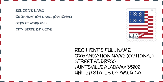
Envelope Example

This is an example of a US zip envelope. You can use a 5-digit zipcode or a detailed 9-digit zipcode to copy the mail in the following address format.
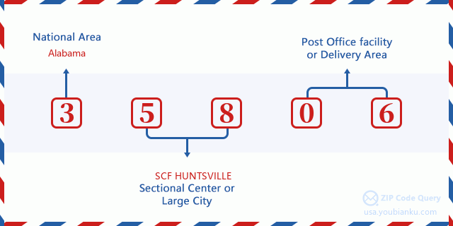
35806 Basic Meaning
What does each digit of ZIP Code 35806 stands for? The first digit designates a national area, which ranges from zero for the Northeast to nine for the far West. The 2-3 digits are the code of a sectional center facility in that region. The last two digits designate small post offices or postal zones.
Online Map

This is online map of the address Huntsville, Alabama, United States. You may use button to move and zoom in / out. The map information is for reference only.
University

This is the ZIP Code 35806 - University page list. Its detail university Name, Street, City, State, ZIP Code, Phone is as below.
| Name | Street | City | State | ZIP Code | Phone |
| Ross Medical Education Center-Huntsville | 930 Old Monrovia Road, NW Ste. 9 | Huntsville | AL | 35806 | (256) 430-9740 |
Hospital

This is the ZIP Code 35806 - Hospital page list. Its detail Hospital Name, Street, City, State, ZIP Code, Phone is as below.
- Name: UNITY PSYCHIATRIC CARE - HUNTSVILLE
- Address: HUNTSVILLE
- City: 5315 MILLENIUM DRIVE, NW
- State: AL
- ZIP Code: 35806
- Phone: (256) 964-6700
Museum

This is the ZIP Code 35806 - Museum page list. Its detail Museum Name, Street, City, State, ZIP Code, Phone is as below.
- Name: SCI-QUEST HANDS-ON SCIENCE CENTER
- Street: 1435 PARAMOUNT DRIVE
- City: HUNTSVILLE
- State: AL
- ZIP Code: 35806
- Phone:
Library

This is the ZIP Code 35806 - Library page list. Its detail Library Name, Address, City, State, ZIP Code, Phone is as below.
- Name: HUNTSVILLE PUBLIC - MONROVIA BRANCH LIBRARY
- Address: 254 ALLEN DRAKE ROAD
- City: HUNTSVILLE
- State: AL - Alabama
- ZIP Code: 35806
- Phone: (256) 489-3392
School
This is the ZIP Code 35806 - School page list. Its detail School Name, Address, City, State, ZIP Code is as below.
| School Name | Address | City | State | Grades | ZIP Code |
|---|---|---|---|---|---|
| Columbia High School | 300 Explorer Boulevard | Huntsville | AL | 09-12 | 35806 |
| Monrovia Middle School | 1216 Jeff Rd | Huntsville | AL | 06-08 | 35806 |
| Monrovia Elementary School | 1030 Jeff Rd | Huntsville | AL | PK-05 | 35806 |
Population for ZIP Code 35806

What is the total population in ZIP Code 35806? Below is detail information.
- Population for ZIP Code 35806: 28,520
- 2010 Population: 18,951
The 2020 demographic statistics are in progress. The current population in ZIP code 35806 is 28,520, and the population in 2010 is 18,951.
Gender

In all the statistical population, the male population is 9,396, the female population is 9,555.
- Male Population: 9,396
- Female Population: 9,555
Race

In all the statistical population, the male population is 9,396, the female population is 9,555.
- White Population: 11,452
- Black Population: 6,543
- Hispanic Population: 512
- Asian Population: 923
- Hawaiian Population: 64
- Indian Population: 241
- Other Population: 251
Age

In all the statistical population, the White population is 11,452, the Black population is 6,543, the Hispanic population is 512, the Asian population is 923, the Hawaiian population is 64, the Indian Ppopulation is 241 and Other population is 251.
- Age's Median: 34.7
- Median of male age: 33.8
- Median of female age: 35.6
Households for ZIP Code 35806
ZIP code 35806 has 8,517 households, with an average number of 2.17 persons per household. The average income per household in Zip code 35806 is 68,255 USD, and the average house value is 235,200 USD.
- Households Per Zipcode: 8,517
- Persons Per Household: 2.17
- Average House Value: 235,200
- Income Per Household: 68,255
Geographic

The latitude of the Zip code 35806 is 34.759182, the longitude is -86.689641, and the elevation is 729. It has land area of 23.278 square miles, and water area of 0.18 square miles. The time zone for ZIP code 35806 is Central (GMT -06:00). Daylight saving time should be observed in the area where the zip code is located.
- Latitude: 34.759182
- Longitude: -86.689641
- Elevation: 729
- Land Area: 23.278
- Water Area: 0.18
- Time Zone: Central (GMT -06:00)
- Region: South
- Division: East South Central
- Day Light Saving: Y
Congressional District

The Congressional District for ZIP code 35806 is Alabama's 05th congressional district, the Congressional Land Area is 3677.31 square mile.
- Congressional District: 05th
- Congressional Land Area: 3677.31
Delivery

In the ZIP code 35806, there are 13,143 residential delivery mailboxes and centralized units, and 1,268 commercial delivery mailbox and centralized units, 6,584 single family deliveries and 4,648 multifamily deliveries, and the box count is 17,050. The main post office has city delivery carrier routes for the ZIP code 35806.
- Delivery Residential: 13,143
- Delivery Business: 1,268
- Delivery Total: 17,050
- Single Family Delivery Units: 6,584
- Multi Family Delivery Units: 4,648
- City Delivery Indicator: Y
Business

In ZIP code 35806, the number of business is 972, the number of employee is 35,718, the business first quarter payroll is 597,583,000 USD, the business annual payroll is 2,420,258,000 USD.
- Number Of Businesses: 972
- Number Of Employees: 35,718
- Business First Quarter Payroll: 597,583,000
- Business Annual Payroll: 2,420,258,000
Social Security Benefits

There are 3,705 beneficiaries with benefits in current-payment status for ZIP code 35806, of which 2,730 are retired workers, 395 are disabled workers, 230 are widow(er)s and parents, 155 are spouses and 195 are children. The number of beneficiaries aged 65 or older is 2,880. The total monthly benefits are 5,542,000 USD, of which 4,386,000 USD for retired workers, 333,000 USD for widow(er)s and parents.
- Total Number: 3,705
- Retired workers Number: 2,730
- Disabled workers Number: 395
- Widow(er)s and parents Number: 230
- Spouses Number: 155
- Children Number: 195
- All beneficiaries per month: 5,542,000
- Retired workers per month: 4,386,000
- Widow(er)s and parents per month: 333,000
- Number of beneficiaries aged 65 or older: 2,880


Add new comment