United States ZIP Code: 40118
This is the Kentucky ZIP Code 40118 page list. Its detail State, County, City, Longitude, Latitude, Envelope Example, Population is as below.

ZIP Code 40118 Information

-
-
Country:
U.S. - United States
State:
State FIPS:
21
Area Code:
ZIP Code:
40118
ZIP Type:
S (Standard)
❓What does S (Standard) mean? A "standard" ZIP Code is what most people think of when they talk about ZIP Codes - essentially a town, city, or a division of a city that has mail service.
ZIP Code 40118 - City

This is the city information corresponding to 40118:
| State | County | City | City Type ?In many cases, a ZIP Code can have multiple "names", meaning cities, towns, or subdivisions, in its boundaries. However, it will ALWAYS have exactly 1 "default" name. D - Default - This is the "preferred" name - by the USPS - for a city. Each ZIP Code has one - and only one - "default" name. In most cases, this is what people who live in that area call the city as well. A - Acceptable - This name can be used for mailing purposes. Often times alternative names are large neighborhoods or sections of the city/town. In some cases a ZIP Code may have several "acceptable" names which is used to group towns under one ZIP Code. N - Not Acceptable - A "not acceptable" name is, in many cases, a nickname that residents give that location. According to the USPS, you should NOT send mail to that ZIP Code using the "not acceptable" name when mailing. | ZIP Code |
|---|---|---|---|---|
| KY | Jefferson | Fairdale | D (Default) | 40118 |
| KY | Jefferson | Hollyvilla | A (Acceptable) | 40118 |
❓What does D (Default) mean? This is the "preferred" name - by the USPS - for a city. Each ZIP Code has one - and only one - "default" name. In most cases, this is what people who live in that area call the city as well.
❓What does A (Acceptable) mean? This name can be used for mailing purposes. Often times alternative names are large neighborhoods or sections of the city/town. In some cases a ZIP Code may have several "acceptable" names which is used to group towns under one ZIP Code.
ZIP Code 40118 Plus 4
ZIP Code 5 plus 4 is the extension of 5-digit zip code, It can be used to locate a more detailed location. The last four digits designate segment or one side of a street or an apartment. You can find the ZIP+4 code and corresponding address of the zip code 40118 below.
| ZIP Code 5 Plus 4 | Address |
|---|---|
| 40118-0001 | PO BOX 1, FAIRDALE, KY |
| 40118-0101 | PO BOX 101, FAIRDALE, KY |
| 40118-0221 | PO BOX 221, FAIRDALE, KY |
| 40118-0341 | PO BOX 341, FAIRDALE, KY |
| 40118-0461 | PO BOX 461, FAIRDALE, KY |
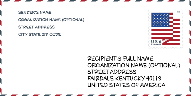
Envelope Example

This is an example of a US zip envelope. You can use a 5-digit zipcode or a detailed 9-digit zipcode to copy the mail in the following address format.
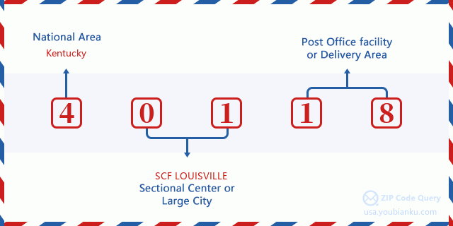
40118 Basic Meaning
What does each digit of ZIP Code 40118 stands for? The first digit designates a national area, which ranges from zero for the Northeast to nine for the far West. The 2-3 digits are the code of a sectional center facility in that region. The last two digits designate small post offices or postal zones.
Online Map

This is online map of the address Hollyvilla, Kentucky, United States. You may use button to move and zoom in / out. The map information is for reference only.
Museum

This is the ZIP Code 40118 - Museum page list. Its detail Museum Name, Street, City, State, ZIP Code, Phone is as below.
- Name: KENTUCKY SOCIETY OF NATURAL HISTORY
- Street: PO BOX 883
- City: FAIRDALE
- State: KY
- ZIP Code: 40118
- Phone:
Library

This is the ZIP Code 40118 - Library page list. Its detail Library Name, Address, City, State, ZIP Code, Phone is as below.
- Name: FAIRDALE BRANCH
- Address: 10620 WEST MANSLICK ROAD
- City: LOUISVILLE
- State: KY - Kentucky
- ZIP Code: 40118
- Phone: (502) 375-2051
School

This is the ZIP Code 40118 - School page list. Its detail School Name, Address, City, State, ZIP Code is as below.
| School Name | Address | City | State | Grades | ZIP Code |
|---|---|---|---|---|---|
| Fairdale Elementary | 10104 Mitchell Hill Road | Fairdale | KY | UG | 40118 |
| Fairdale High | 1001 Fairdale Road | Fairdale | KY | UG | 40118 |
| Coral Ridge Elementary | 10608 National Turnpike | Fairdale | KY | UG | 40118 |
| Georgia Chaffee Teenage Parent Program | 1010 Neighborhood Pl | Fairdale | KY | UG | 40118 |
Population for ZIP Code 40118

What is the total population in ZIP Code 40118? Below is detail information.
- Population for ZIP Code 40118: 10,423
- 2010 Population: 9,724
The 2020 demographic statistics are in progress. The current population in ZIP code 40118 is 10,423, and the population in 2010 is 9,724.
Gender

In all the statistical population, the male population is 4,788, the female population is 4,936.
- Male Population: 4,788
- Female Population: 4,936
Race

In all the statistical population, the male population is 4,788, the female population is 4,936.
- White Population: 8,891
- Black Population: 324
- Hispanic Population: 861
- Asian Population: 94
- Hawaiian Population: 20
- Indian Population: 74
- Other Population: 522
Age

In all the statistical population, the White population is 8,891, the Black population is 324, the Hispanic population is 861, the Asian population is 94, the Hawaiian population is 20, the Indian Ppopulation is 74 and Other population is 522.
- Age's Median: 36.1
- Median of male age: 34.7
- Median of female age: 37.4
Households for ZIP Code 40118
ZIP code 40118 has 3,772 households, with an average number of 2.58 persons per household. The average income per household in Zip code 40118 is 52,848 USD, and the average house value is 104,300 USD.
- Households Per Zipcode: 3,772
- Persons Per Household: 2.58
- Average House Value: 104,300
- Income Per Household: 52,848
Geographic

The latitude of the Zip code 40118 is 38.096265, the longitude is -85.753312, and the elevation is 527. It has land area of 13.684 square miles, and water area of 0.114 square miles. The time zone for ZIP code 40118 is Eastern (GMT -05:00). Daylight saving time should be observed in the area where the zip code is located.
- Latitude: 38.096265
- Longitude: -85.753312
- Elevation: 527
- Land Area: 13.684
- Water Area: 0.114
- Time Zone: Eastern (GMT -05:00)
- Region: South
- Division: East South Central
- Day Light Saving: Y
Congressional District

The Congressional District for ZIP code 40118 is Kentucky's 3rd congressional district, the Congressional Land Area is 319.34 square mile.
- Congressional District: 3rd
- Congressional Land Area: 319.34
Delivery

In the ZIP code 40118, there are 4,040 residential delivery mailboxes and centralized units, and 107 commercial delivery mailbox and centralized units, 2,745 single family deliveries and 301 multifamily deliveries, and the box count is 4,484. The main post office does not have city delivery carrier routes for the ZIP code 40118.
- Delivery Residential: 4,040
- Delivery Business: 107
- Delivery Total: 4,484
- Single Family Delivery Units: 2,745
- Multi Family Delivery Units: 301
- City Delivery Indicator: N
Business

In ZIP code 40118, the number of business is 82, the number of employee is 1,225, the business first quarter payroll is 9,518,000 USD, the business annual payroll is 40,530,000 USD.
- Number Of Businesses: 82
- Number Of Employees: 1,225
- Business First Quarter Payroll: 9,518,000
- Business Annual Payroll: 40,530,000
Social Security Benefits

There are 2,145 beneficiaries with benefits in current-payment status for ZIP code 40118, of which 1,265 are retired workers, 475 are disabled workers, 160 are widow(er)s and parents, 50 are spouses and 195 are children. The number of beneficiaries aged 65 or older is 1,350. The total monthly benefits are 2,707,000 USD, of which 1,756,000 USD for retired workers, 203,000 USD for widow(er)s and parents.
- Total Number: 2,145
- Retired workers Number: 1,265
- Disabled workers Number: 475
- Widow(er)s and parents Number: 160
- Spouses Number: 50
- Children Number: 195
- All beneficiaries per month: 2,707,000
- Retired workers per month: 1,756,000
- Widow(er)s and parents per month: 203,000
- Number of beneficiaries aged 65 or older: 1,350


Add new comment