United States ZIP Code: 42633
This is the Kentucky ZIP Code 42633 page list. Its detail State, County, City, Longitude, Latitude, Envelope Example, Population is as below.

ZIP Code 42633 Information

-
-
Country:
U.S. - United States
State:
State FIPS:
21
Area Code:
ZIP Code:
42633
ZIP Type:
S (Standard)
❓What does S (Standard) mean? A "standard" ZIP Code is what most people think of when they talk about ZIP Codes - essentially a town, city, or a division of a city that has mail service.
ZIP Code 42633 - City

This is the city information corresponding to 42633:
| State | County | City | City Type ?In many cases, a ZIP Code can have multiple "names", meaning cities, towns, or subdivisions, in its boundaries. However, it will ALWAYS have exactly 1 "default" name. D - Default - This is the "preferred" name - by the USPS - for a city. Each ZIP Code has one - and only one - "default" name. In most cases, this is what people who live in that area call the city as well. A - Acceptable - This name can be used for mailing purposes. Often times alternative names are large neighborhoods or sections of the city/town. In some cases a ZIP Code may have several "acceptable" names which is used to group towns under one ZIP Code. N - Not Acceptable - A "not acceptable" name is, in many cases, a nickname that residents give that location. According to the USPS, you should NOT send mail to that ZIP Code using the "not acceptable" name when mailing. | ZIP Code |
|---|---|---|---|---|
| KY | Wayne | Barrier | A (Acceptable) | 42633 |
| KY | Wayne | Bethesda | A (Acceptable) | 42633 |
| KY | Wayne | Betsey | A (Acceptable) | 42633 |
| KY | Wayne | Coopersville | A (Acceptable) | 42633 |
| KY | Wayne | Delta | A (Acceptable) | 42633 |
| KY | Wayne | Frazer | A (Acceptable) | 42633 |
| KY | Wayne | Frisby | A (Acceptable) | 42633 |
| KY | Wayne | Gregory | A (Acceptable) | 42633 |
| KY | Wayne | Mill Springs | A (Acceptable) | 42633 |
| KY | Wayne | Monticello | D (Default) | 42633 |
| KY | Wayne | Mount Pisgah | A (Acceptable) | 42633 |
| KY | Wayne | Number One | A (Acceptable) | 42633 |
| KY | Wayne | Oil Valley | A (Acceptable) | 42633 |
| KY | Wayne | Parnell | A (Acceptable) | 42633 |
| KY | Wayne | Powersburg | A (Acceptable) | 42633 |
| KY | Wayne | Pueblo | A (Acceptable) | 42633 |
| KY | Wayne | Ritner | A (Acceptable) | 42633 |
| KY | Wayne | Rockybranch | A (Acceptable) | 42633 |
| KY | Wayne | Slat | A (Acceptable) | 42633 |
| KY | Wayne | Steubenville | A (Acceptable) | 42633 |
| KY | Wayne | Stop | A (Acceptable) | 42633 |
| KY | Wayne | Sunnybrook | A (Acceptable) | 42633 |
| KY | Wayne | Susie | A (Acceptable) | 42633 |
| KY | Wayne | Touristville | A (Acceptable) | 42633 |
| KY | Wayne | Windy | A (Acceptable) | 42633 |
❓What does D (Default) mean? This is the "preferred" name - by the USPS - for a city. Each ZIP Code has one - and only one - "default" name. In most cases, this is what people who live in that area call the city as well.
❓What does A (Acceptable) mean? This name can be used for mailing purposes. Often times alternative names are large neighborhoods or sections of the city/town. In some cases a ZIP Code may have several "acceptable" names which is used to group towns under one ZIP Code.
ZIP Code 42633 Plus 4
ZIP Code 5 plus 4 is the extension of 5-digit zip code, It can be used to locate a more detailed location. The last four digits designate segment or one side of a street or an apartment. You can find the ZIP+4 code and corresponding address of the zip code 42633 below.
| ZIP Code 5 Plus 4 | Address |
|---|---|
| 42633-0001 | PO BOX 1, MONTICELLO, KY |
| 42633-0121 | PO BOX 121, MONTICELLO, KY |
| 42633-0241 | PO BOX 241, MONTICELLO, KY |
| 42633-0361 | PO BOX 361, MONTICELLO, KY |
| 42633-0451 | PO BOX 451, MONTICELLO, KY |
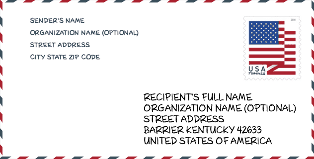
Envelope Example

This is an example of a US zip envelope. You can use a 5-digit zipcode or a detailed 9-digit zipcode to copy the mail in the following address format.
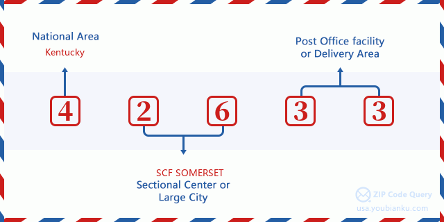
42633 Basic Meaning
What does each digit of ZIP Code 42633 stands for? The first digit designates a national area, which ranges from zero for the Northeast to nine for the far West. The 2-3 digits are the code of a sectional center facility in that region. The last two digits designate small post offices or postal zones.
Online Map

This is online map of the address Windy, Kentucky, United States. You may use button to move and zoom in / out. The map information is for reference only.
Hospital

This is the ZIP Code 42633 - Hospital page list. Its detail Hospital Name, Street, City, State, ZIP Code, Phone is as below.
- Name: WAYNE COUNTY HOSPITAL
- Address: MONTICELLO
- City: 166 HOSPITAL STREET
- State: KY
- ZIP Code: 42633
- Phone: (606) 348-9343
Library

This is the ZIP Code 42633 - Library page list. Its detail Library Name, Address, City, State, ZIP Code, Phone is as below.
| Name | Address | City | State | ZIP Code | Phone |
|---|---|---|---|---|---|
| WAYNE COUNTY PUBLIC LIBRARY | 157 ROLLING HILLS BLVD | MONTICELLO | KY | 42633 | (606) 348-8565 |
| WAYNE COUNTY PUBLIC LIBRARY | 150 SOUTH MAIN STREET | MONTICELLO | KY | 42633 | (606) 348-8565 |
School

This is the ZIP Code 42633 - School page list. Its detail School Name, Address, City, State, ZIP Code is as below.
| School Name | Address | City | State | Grades | ZIP Code |
|---|---|---|---|---|---|
| Wayne County Area Technology Center | 38 ACADEMIC AVE | Monticello | KY | UG | 42633 |
| Wayne County High School | 2 Kenny Davis Blvd | Monticello | KY | UG | 42633 |
| Lake Cumberland Youth Development Center | 9000 Hwy 1546 | Monticello | KY | UG | 42633 |
| Walker Early Learning Center | 1080 South Main Street | Monticello | KY | UG | 42633 |
| Bell Elementary School | 278 Kenny Davis Blvd. | Monticello | KY | UG | 42633 |
| Wayne County Middle School | 95 Champion Drive | Monticello | KY | UG | 42633 |
| Otter Creek Academy | 1442 Old Bethel Church Rd | Monticello | KY | UG | 42633 |
| Monticello Elementary School | 160 Cave St | Monticello | KY | UG | 42633 |
| Wayne County Learning Academy | 1025 SOUTH MAIN STREET | Monticello | KY | UG | 42633 |
Population for ZIP Code 42633

What is the total population in ZIP Code 42633? Below is detail information.
- Population for ZIP Code 42633: 19,659
- 2010 Population: 20,065
The 2020 demographic statistics are in progress. The current population in ZIP code 42633 is 19,659, and the population in 2010 is 20,065.
Gender

In all the statistical population, the male population is 9,927, the female population is 10,138.
- Male Population: 9,927
- Female Population: 10,138
Race

In all the statistical population, the male population is 9,927, the female population is 10,138.
- White Population: 19,315
- Black Population: 415
- Hispanic Population: 591
- Asian Population: 68
- Hawaiian Population: 16
- Indian Population: 144
- Other Population: 366
Age

In all the statistical population, the White population is 19,315, the Black population is 415, the Hispanic population is 591, the Asian population is 68, the Hawaiian population is 16, the Indian Ppopulation is 144 and Other population is 366.
- Age's Median: 40.8
- Median of male age: 39.7
- Median of female age: 41.9
Households for ZIP Code 42633
ZIP code 42633 has 8,321 households, with an average number of 2.37 persons per household. The average income per household in Zip code 42633 is 33,869 USD, and the average house value is 80,100 USD.
- Households Per Zipcode: 8,321
- Persons Per Household: 2.37
- Average House Value: 80,100
- Income Per Household: 33,869
Geographic

The latitude of the Zip code 42633 is 36.792874, the longitude is -84.811151, and the elevation is 934. It has land area of 434.933 square miles, and water area of 19.447 square miles. The time zone for ZIP code 42633 is Eastern (GMT -05:00). Daylight saving time should be observed in the area where the zip code is located.
- Latitude: 36.792874
- Longitude: -84.811151
- Elevation: 934
- Land Area: 434.933
- Water Area: 19.447
- Time Zone: Eastern (GMT -05:00)
- Region: South
- Division: East South Central
- Day Light Saving: Y
Congressional District

The Congressional District for ZIP code 42633 is Kentucky's 05th congressional district, the Congressional Land Area is 11235.15 square mile.
- Congressional District: 05th
- Congressional Land Area: 11235.15
Delivery

In the ZIP code 42633, there are 8,295 residential delivery mailboxes and centralized units, and 410 commercial delivery mailbox and centralized units, 7,828 single family deliveries and 1 multifamily deliveries, and the box count is 9,402. The main post office has city delivery carrier routes for the ZIP code 42633.
- Delivery Residential: 8,295
- Delivery Business: 410
- Delivery Total: 9,402
- Single Family Delivery Units: 7,828
- Multi Family Delivery Units: 1
- City Delivery Indicator: Y
Business

In ZIP code 42633, the number of business is 264, the number of employee is 4,283, the business first quarter payroll is 27,486,000 USD, the business annual payroll is 118,625,000 USD.
- Number Of Businesses: 264
- Number Of Employees: 4,283
- Business First Quarter Payroll: 27,486,000
- Business Annual Payroll: 118,625,000
Social Security Benefits

There are 5,245 beneficiaries with benefits in current-payment status for ZIP code 42633, of which 3,000 are retired workers, 1,175 are disabled workers, 440 are widow(er)s and parents, 210 are spouses and 420 are children. The number of beneficiaries aged 65 or older is 3,370. The total monthly benefits are 5,666,000 USD, of which 3,645,000 USD for retired workers, 438,000 USD for widow(er)s and parents.
- Total Number: 5,245
- Retired workers Number: 3,000
- Disabled workers Number: 1,175
- Widow(er)s and parents Number: 440
- Spouses Number: 210
- Children Number: 420
- All beneficiaries per month: 5,666,000
- Retired workers per month: 3,645,000
- Widow(er)s and parents per month: 438,000
- Number of beneficiaries aged 65 or older: 3,370


Add new comment