United States ZIP Code: 48322
This is the Michigan ZIP Code 48322 page list. Its detail State, County, City, Longitude, Latitude, Envelope Example, Population is as below.
ZIP Code 48322 Information

-
-
Country:
U.S. - United States
State:
State FIPS:
26
Area Code:
ZIP Code:
48322
ZIP Type:
S (Standard)
❓What does S (Standard) mean? A "standard" ZIP Code is what most people think of when they talk about ZIP Codes - essentially a town, city, or a division of a city that has mail service.
ZIP Code 48322 - City

This is the city information corresponding to 48322:
| State | County | City | City Type ?In many cases, a ZIP Code can have multiple "names", meaning cities, towns, or subdivisions, in its boundaries. However, it will ALWAYS have exactly 1 "default" name. D - Default - This is the "preferred" name - by the USPS - for a city. Each ZIP Code has one - and only one - "default" name. In most cases, this is what people who live in that area call the city as well. A - Acceptable - This name can be used for mailing purposes. Often times alternative names are large neighborhoods or sections of the city/town. In some cases a ZIP Code may have several "acceptable" names which is used to group towns under one ZIP Code. N - Not Acceptable - A "not acceptable" name is, in many cases, a nickname that residents give that location. According to the USPS, you should NOT send mail to that ZIP Code using the "not acceptable" name when mailing. | ZIP Code |
|---|---|---|---|---|
| MI | Oakland | W Bloomfield | A (Acceptable) | 48322 |
| MI | Oakland | West Bloomfield | D (Default) | 48322 |
❓What does D (Default) mean? This is the "preferred" name - by the USPS - for a city. Each ZIP Code has one - and only one - "default" name. In most cases, this is what people who live in that area call the city as well.
❓What does A (Acceptable) mean? This name can be used for mailing purposes. Often times alternative names are large neighborhoods or sections of the city/town. In some cases a ZIP Code may have several "acceptable" names which is used to group towns under one ZIP Code.
ZIP Code 48322 Plus 4
ZIP Code 5 plus 4 is the extension of 5-digit zip code, It can be used to locate a more detailed location. The last four digits designate segment or one side of a street or an apartment. You can find the ZIP+4 code and corresponding address of the zip code 48322 below.
| ZIP Code 5 Plus 4 | Address |
|---|---|
| 48322-0899 | 59001 MARISTRA DR, WEST BLOOMFIELD, MI |
| 48322-1000 | 6000 EASTBROOKE, WEST BLOOMFIELD, MI |
| 48322-1011 | 2000 HAGGERTY RD, WEST BLOOMFIELD, MI |
| 48322-1014 | 6017 SILVERBROOK, WEST BLOOMFIELD, MI |
| 48322-1016 | 6115 SILVERBROOK, WEST BLOOMFIELD, MI |
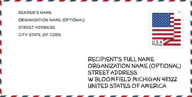
Envelope Example

This is an example of a US zip envelope. You can use a 5-digit zipcode or a detailed 9-digit zipcode to copy the mail in the following address format.
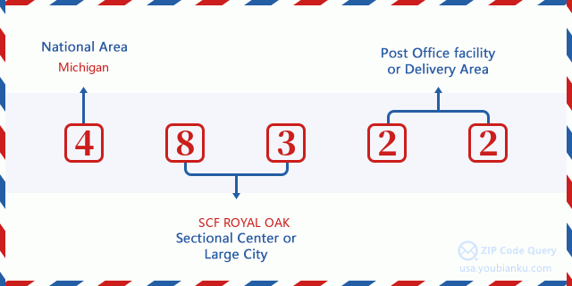
48322 Basic Meaning
What does each digit of ZIP Code 48322 stands for? The first digit designates a national area, which ranges from zero for the Northeast to nine for the far West. The 2-3 digits are the code of a sectional center facility in that region. The last two digits designate small post offices or postal zones.
Online Map

This is online map of the address West Bloomfield, Michigan, United States. You may use button to move and zoom in / out. The map information is for reference only.
Hospital

This is the ZIP Code 48322 - Hospital page list. Its detail Hospital Name, Street, City, State, ZIP Code, Phone is as below.
- Name: HENRY FORD WEST BLOOMFIELD HOSPITAL
- Address: WEST BLOOMFIELD
- City: 6777 WEST MAPLE ROAD
- State: MI
- ZIP Code: 48322
- Phone: (248) 325-1000
Museum

This is the ZIP Code 48322 - Museum page list. Its detail Museum Name, Street, City, State, ZIP Code, Phone is as below.
- Name: SHALOM STREET
- Street: 6600 WEST MAPLE ROAD
- City: WEST BLOOMFIELD
- State: MI
- ZIP Code: 48322
- Phone: (248) 432-5454
School

This is the ZIP Code 48322 - School page list. Its detail School Name, Address, City, State, ZIP Code is as below.
- School Name: West Bloomfield Transition Center
- Address: 7071 Orchard Lake Road STE 120
- City: West Bloomfield
- State: MI
- Grades: UG
- ZIP Code: 48322
Population for ZIP Code 48322

What is the total population in ZIP Code 48322? Below is detail information.
- Population for ZIP Code 48322: 33,460
- 2010 Population: 31,265
The 2020 demographic statistics are in progress. The current population in ZIP code 48322 is 33,460, and the population in 2010 is 31,265.
Gender

In all the statistical population, the male population is 14,749, the female population is 16,516.
- Male Population: 14,749
- Female Population: 16,516
Race

In all the statistical population, the male population is 14,749, the female population is 16,516.
- White Population: 22,742
- Black Population: 5,257
- Hispanic Population: 421
- Asian Population: 3,544
- Hawaiian Population: 82
- Indian Population: 160
- Other Population: 232
Age

In all the statistical population, the White population is 22,742, the Black population is 5,257, the Hispanic population is 421, the Asian population is 3,544, the Hawaiian population is 82, the Indian Ppopulation is 160 and Other population is 232.
- Age's Median: 44.9
- Median of male age: 43.2
- Median of female age: 46.2
Households for ZIP Code 48322
ZIP code 48322 has 11,909 households, with an average number of 2.59 persons per household. The average income per household in Zip code 48322 is 88,850 USD, and the average house value is 277,400 USD.
- Households Per Zipcode: 11,909
- Persons Per Household: 2.59
- Average House Value: 277,400
- Income Per Household: 88,850
Geographic

The latitude of the Zip code 48322 is 42.542943, the longitude is -83.379712, and the elevation is 945. It has land area of 11.757 square miles, and water area of 0.067 square miles. The time zone for ZIP code 48322 is Eastern (GMT -05:00). Daylight saving time should be observed in the area where the zip code is located.
- Latitude: 42.542943
- Longitude: -83.379712
- Elevation: 945
- Land Area: 11.757
- Water Area: 0.067
- Time Zone: Eastern (GMT -05:00)
- Region: Midwest
- Division: East North Central
- Day Light Saving: Y
Congressional District

The Congressional District for ZIP code 48322 is Michigan's 14th congressional district, the Congressional Land Area is 185.73 square mile.
- Congressional District: 14th
- Congressional Land Area: 185.73
Delivery

In the ZIP code 48322, there are 12,919 residential delivery mailboxes and centralized units, and 812 commercial delivery mailbox and centralized units, 7,889 single family deliveries and 697 multifamily deliveries, and the box count is 13,564. The main post office has city delivery carrier routes for the ZIP code 48322.
- Delivery Residential: 12,919
- Delivery Business: 812
- Delivery Total: 13,564
- Single Family Delivery Units: 7,889
- Multi Family Delivery Units: 697
- City Delivery Indicator: Y
Business

In ZIP code 48322, the number of business is 944, the number of employee is 13,367, the business first quarter payroll is 137,616,000 USD, the business annual payroll is 562,423,000 USD.
- Number Of Businesses: 944
- Number Of Employees: 13,367
- Business First Quarter Payroll: 137,616,000
- Business Annual Payroll: 562,423,000
Social Security Benefits

There are 7,740 beneficiaries with benefits in current-payment status for ZIP code 48322, of which 5,990 are retired workers, 525 are disabled workers, 505 are widow(er)s and parents, 400 are spouses and 320 are children. The number of beneficiaries aged 65 or older is 6,685. The total monthly benefits are 13,292,000 USD, of which 11,075,000 USD for retired workers, 825,000 USD for widow(er)s and parents.
- Total Number: 7,740
- Retired workers Number: 5,990
- Disabled workers Number: 525
- Widow(er)s and parents Number: 505
- Spouses Number: 400
- Children Number: 320
- All beneficiaries per month: 13,292,000
- Retired workers per month: 11,075,000
- Widow(er)s and parents per month: 825,000
- Number of beneficiaries aged 65 or older: 6,685


Add new comment