ZIP Code: 71118, Shreveport, LA
ZIP Code 71118 is located in Shreveport, Louisiana. Its detail State, County, City, Longitude, Latitude, Envelope Example, Population is as below.
ZIP Code 71118 Information

-
-
Country:
U.S. - United States
State:
County FIPS:
22017
County:
City:
Area Code:
City Type ?In many cases, a ZIP Code can have multiple "names", meaning cities, towns, or subdivisions, in its boundaries. However, it will ALWAYS have exactly 1 "default" name. D - Default - This is the "preferred" name - by the USPS - for a city. Each ZIP Code has one - and only one - "default" name. In most cases, this is what people who live in that area call the city as well. A - Acceptable - This name can be used for mailing purposes. Often times alternative names are large neighborhoods or sections of the city/town. In some cases a ZIP Code may have several "acceptable" names which is used to group towns under one ZIP Code. N - Not Acceptable - A "not acceptable" name is, in many cases, a nickname that residents give that location. According to the USPS, you should NOT send mail to that ZIP Code using the "not acceptable" name when mailing.:
D (Default)
ZIP Code:
71118
❓What does D (Default) mean? This is the "preferred" name - by the USPS - for a city. Each ZIP Code has one - and only one - "default" name. In most cases, this is what people who live in that area call the city as well.
ZIP Code 71118 Plus 4
ZIP Code 5 plus 4 is the extension of 5-digit zip code, It can be used to locate a more detailed location. The last four digits designate segment or one side of a street or an apartment. You can find the ZIP+4 code and corresponding address of the zip code 71118 below.
| ZIP Code 5 Plus 4 | Address |
|---|---|
| 71118-2000 | 8801 SAINT CLAIR ST, SHREVEPORT, LA |
| 71118-2001 | 8801 BAYONNE DR, SHREVEPORT, LA |
| 71118-2002 | 8800 BAYONNE DR, SHREVEPORT, LA |
| 71118-2003 | 8901 BAYONNE DR, SHREVEPORT, LA |
| 71118-2004 | 8801 BERNAY DR, SHREVEPORT, LA |
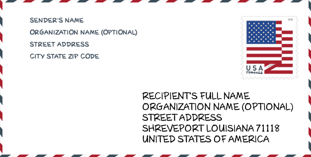
Envelope Example

This is an example of a US zip envelope. You can use a 5-digit zipcode or a detailed 9-digit zipcode to copy the mail in the following address format.
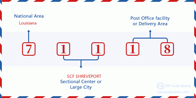
71118 Basic Meaning
What does each digit of ZIP Code 71118 stands for? The first digit designates a national area, which ranges from zero for the Northeast to nine for the far West. The 2-3 digits are the code of a sectional center facility in that region. The last two digits designate small post offices or postal zones.
Online Map

This is online map of the address Shreveport, Louisiana, United States. You may use button to move and zoom in / out. The map information is for reference only.
University

This is the ZIP Code 71118 - University page list. Its detail university Name, Street, City, State, ZIP Code, Phone is as below.
| Name | Street | City | State | ZIP Code | Phone |
| Ayers Career College | 8820 Jewella Ave | Shreveport | LA | 71118 | (318) 868-3000 |
Library

This is the ZIP Code 71118 - Library page list. Its detail Library Name, Address, City, State, ZIP Code, Phone is as below.
- Name: HAMILTON & SOUTH CADDO BRANCH
- Address: 2111 BERT KOUNS INDUSTRIAL LOOP
- City: SHREVEPORT
- State: LA - Louisiana
- ZIP Code: 71118
- Phone: (318) 687-6824
School
This is the ZIP Code 71118 - School page list. Its detail School Name, Address, City, State, ZIP Code is as below.
| School Name | Address | City | State | Grades | ZIP Code |
|---|---|---|---|---|---|
| Forest Hill Elementary School | 2005 Francais Drive | Shreveport | LA | UG | 71118 |
| Southern Hills Elementary School | 9075 Kingston Road | Shreveport | LA | UG | 71118 |
| Southwood High School | 9000 Walker Road | Shreveport | LA | UG | 71118 |
| Summerfield Elementary School | 3131 Ardis Taylor Drive | Shreveport | LA | UG | 71118 |
| Summer Grove Elementary School | 2955 Bert Kouns Industrial Loop | Shreveport | LA | UG | 71118 |
| Pathways in Education-Louisiana Inc. | 8999 Mansfield Rd. | Shreveport | LA | UG | 71118 |
Population for ZIP Code 71118

What is the total population in ZIP Code 71118? Below is detail information.
- Population for ZIP Code 71118: 25,206
- 2010 Population: 24,761
The 2020 demographic statistics are in progress. The current population in ZIP code 71118 is 25,206, and the population in 2010 is 24,761.
Gender

In all the statistical population, the male population is 11,349, the female population is 13,412.
- Male Population: 11,349
- Female Population: 13,412
Race

In all the statistical population, the male population is 11,349, the female population is 13,412.
- White Population: 14,850
- Black Population: 9,269
- Hispanic Population: 629
- Asian Population: 485
- Hawaiian Population: 30
- Indian Population: 276
- Other Population: 267
Age

In all the statistical population, the White population is 14,850, the Black population is 9,269, the Hispanic population is 629, the Asian population is 485, the Hawaiian population is 30, the Indian Ppopulation is 276 and Other population is 267.
- Age's Median: 36.3
- Median of male age: 34.3
- Median of female age: 38.0
Households for ZIP Code 71118
ZIP code 71118 has 10,076 households, with an average number of 2.41 persons per household. The average income per household in Zip code 71118 is 43,822 USD, and the average house value is 145,600 USD.
- Households Per Zipcode: 10,076
- Persons Per Household: 2.41
- Average House Value: 145,600
- Income Per Household: 43,822
Geographic

The latitude of the Zip code 71118 is 32.388432, the longitude is -93.807162, and the elevation is 200. It has land area of 13.202 square miles, and water area of 0.098 square miles. The time zone for ZIP code 71118 is Central (GMT -06:00). Daylight saving time should be observed in the area where the zip code is located.
- Latitude: 32.388432
- Longitude: -93.807162
- Elevation: 200
- Land Area: 13.202
- Water Area: 0.098
- Time Zone: Central (GMT -06:00)
- Region: South
- Division: West South Central
- Day Light Saving: Y
Congressional District

The Congressional District for ZIP code 71118 is Louisiana's 04th congressional district, the Congressional Land Area is 12435.1 square mile.
- Congressional District: 04th
- Congressional Land Area: 12435.1
Delivery

In the ZIP code 71118, there are 10,459 residential delivery mailboxes and centralized units, and 641 commercial delivery mailbox and centralized units, 7,261 single family deliveries and 2,456 multifamily deliveries, and the box count is 12,014. The main post office has city delivery carrier routes for the ZIP code 71118.
- Delivery Residential: 10,459
- Delivery Business: 641
- Delivery Total: 12,014
- Single Family Delivery Units: 7,261
- Multi Family Delivery Units: 2,456
- City Delivery Indicator: Y
Business

In ZIP code 71118, the number of business is 434, the number of employee is 5,529, the business first quarter payroll is 44,648,000 USD, the business annual payroll is 180,727,000 USD.
- Number Of Businesses: 434
- Number Of Employees: 5,529
- Business First Quarter Payroll: 44,648,000
- Business Annual Payroll: 180,727,000
Social Security Benefits

There are 4,960 beneficiaries with benefits in current-payment status for ZIP code 71118, of which 3,235 are retired workers, 740 are disabled workers, 395 are widow(er)s and parents, 140 are spouses and 450 are children. The number of beneficiaries aged 65 or older is 3,575. The total monthly benefits are 6,383,000 USD, of which 4,564,000 USD for retired workers, 533,000 USD for widow(er)s and parents.
- Total Number: 4,960
- Retired workers Number: 3,235
- Disabled workers Number: 740
- Widow(er)s and parents Number: 395
- Spouses Number: 140
- Children Number: 450
- All beneficiaries per month: 6,383,000
- Retired workers per month: 4,564,000
- Widow(er)s and parents per month: 533,000
- Number of beneficiaries aged 65 or older: 3,575


Add new comment