United States ZIP Code: 84511
This is the Utah ZIP Code 84511 page list. Its detail State, County, City, Longitude, Latitude, Envelope Example, Population is as below.

ZIP Code 84511 Information

ZIP Code 84511 - City

This is the city information corresponding to 84511:
| State | County | City | City Type ?In many cases, a ZIP Code can have multiple "names", meaning cities, towns, or subdivisions, in its boundaries. However, it will ALWAYS have exactly 1 "default" name. D - Default - This is the "preferred" name - by the USPS - for a city. Each ZIP Code has one - and only one - "default" name. In most cases, this is what people who live in that area call the city as well. A - Acceptable - This name can be used for mailing purposes. Often times alternative names are large neighborhoods or sections of the city/town. In some cases a ZIP Code may have several "acceptable" names which is used to group towns under one ZIP Code. N - Not Acceptable - A "not acceptable" name is, in many cases, a nickname that residents give that location. According to the USPS, you should NOT send mail to that ZIP Code using the "not acceptable" name when mailing. | ZIP Code |
|---|---|---|---|---|
| UT | San Juan | Blanding | D (Default) | 84511 |
| UT | San Juan | White Mesa | A (Acceptable) | 84511 |
❓What does D (Default) mean? This is the "preferred" name - by the USPS - for a city. Each ZIP Code has one - and only one - "default" name. In most cases, this is what people who live in that area call the city as well.
❓What does A (Acceptable) mean? This name can be used for mailing purposes. Often times alternative names are large neighborhoods or sections of the city/town. In some cases a ZIP Code may have several "acceptable" names which is used to group towns under one ZIP Code.
ZIP Code 84511 Plus 4
ZIP Code 5 plus 4 is the extension of 5-digit zip code, It can be used to locate a more detailed location. The last four digits designate segment or one side of a street or an apartment. You can find the ZIP+4 code and corresponding address of the zip code 84511 below.
| ZIP Code 5 Plus 4 | Address |
|---|---|
| 84511-0001 | PO BOX 1, BLANDING, UT |
| 84511-0089 | PO BOX 0, BLANDING, UT |
| 84511-0090 | PO BOX 0, BLANDING, UT |
| 84511-0091 | PO BOX 91, BLANDING, UT |
| 84511-0119 | PO BOX 0, BLANDING, UT |
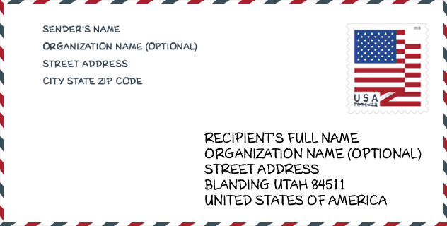
Envelope Example

This is an example of a US zip envelope. You can use a 5-digit zipcode or a detailed 9-digit zipcode to copy the mail in the following address format.
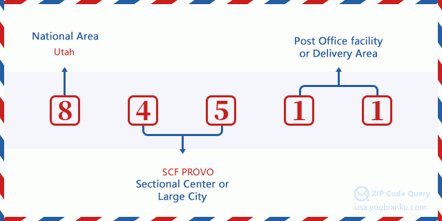
84511 Basic Meaning
What does each digit of ZIP Code 84511 stands for? The first digit designates a national area, which ranges from zero for the Northeast to nine for the far West. The 2-3 digits are the code of a sectional center facility in that region. The last two digits designate small post offices or postal zones.
Online Map

This is online map of the address White Mesa, Utah, United States. You may use button to move and zoom in / out. The map information is for reference only.
Hospital

This is the ZIP Code 84511 - Hospital page list. Its detail Hospital Name, Street, City, State, ZIP Code, Phone is as below.
- Name: BLUE MOUNTAIN HOSPITAL
- Address: BLANDING
- City: 802 SOUTH 200 WEST
- State: UT
- ZIP Code: 84511
- Phone: (435) 678-3993
Museum

This is the ZIP Code 84511 - Museum page list. Its detail Museum Name, Street, City, State, ZIP Code, Phone is as below.
| Name | Street | City | State | ZIP Code | Phone |
| HUCK'S MUSEUM AND TRADING POST | S HIGHWAY 191 | BLANDING | UT | 84511 | (435) 678-2329 |
| EDGE OF CEDARS MUSEUM | 660 W 400 N | BLANDING | UT | 84511 | (435) 678-2238 |
Library

This is the ZIP Code 84511 - Library page list. Its detail Library Name, Address, City, State, ZIP Code, Phone is as below.
| Name | Address | City | State | ZIP Code | Phone |
|---|---|---|---|---|---|
| SAN JUAN COUNTY LIBRARY | 25 WEST 300 SOUTH | BLANDING | UT | 84511 | (435) 678-2335 |
| SAN JUAN COUNTY LIBRARY BLANDING BRANCH | 25 WEST 300 SOUTH | BLANDING | UT | 84511 | (435) 678-2335 |
School

This is the ZIP Code 84511 - School page list. Its detail School Name, Address, City, State, ZIP Code is as below.
| School Name | Address | City | State | Grades | ZIP Code |
|---|---|---|---|---|---|
| Albert R. Lyman Middle | 535 N 100 E | BLANDING | UT | UG | 84511 |
| Blanding School | 302 S 100 W | BLANDING | UT | UG | 84511 |
| San Juan High | 311 N 100 E | BLANDING | UT | UG | 84511 |
Population for ZIP Code 84511

What is the total population in ZIP Code 84511? Below is detail information.
- Population for ZIP Code 84511: 4,456
- 2010 Population: 4,672
The 2020 demographic statistics are in progress. The current population in ZIP code 84511 is 4,456, and the population in 2010 is 4,672.
Gender

In all the statistical population, the male population is 2,307, the female population is 2,365.
- Male Population: 2,307
- Female Population: 2,365
Race

In all the statistical population, the male population is 2,307, the female population is 2,365.
- White Population: 3,159
- Black Population: 34
- Hispanic Population: 176
- Asian Population: 28
- Hawaiian Population: 16
- Indian Population: 1,553
- Other Population: 51
Age

In all the statistical population, the White population is 3,159, the Black population is 34, the Hispanic population is 176, the Asian population is 28, the Hawaiian population is 16, the Indian Ppopulation is 1,553 and Other population is 51.
- Age's Median: 27.7
- Median of male age: 25.7
- Median of female age: 29.4
Households for ZIP Code 84511
ZIP code 84511 has 1,405 households, with an average number of 3.22 persons per household. The average income per household in Zip code 84511 is 59,097 USD, and the average house value is 165,800 USD.
- Households Per Zipcode: 1,405
- Persons Per Household: 3.22
- Average House Value: 165,800
- Income Per Household: 59,097
Geographic

The latitude of the Zip code 84511 is 37.719716, the longitude is -109.792022, and the elevation is 8316. It has land area of 430.662 square miles, and water area of 1.298 square miles. The time zone for ZIP code 84511 is Mountain (GMT -07:00). Daylight saving time should be observed in the area where the zip code is located.
- Latitude: 37.719716
- Longitude: -109.792022
- Elevation: 8316
- Land Area: 430.662
- Water Area: 1.298
- Time Zone: Mountain (GMT -07:00)
- Region: West
- Division: Mountain
- Day Light Saving: Y
Congressional District

The Congressional District for ZIP code 84511 is Utah's 3rd congressional district, the Congressional Land Area is 20070.54 square mile.
- Congressional District: 3rd
- Congressional Land Area: 20070.54
Delivery

In the ZIP code 84511, there are 1,384 residential delivery mailboxes and centralized units, and 108 commercial delivery mailbox and centralized units, 12 single family deliveries and 0 multifamily deliveries, and the box count is 1,694. The main post office has city delivery carrier routes for the ZIP code 84511.
- Delivery Residential: 1,384
- Delivery Business: 108
- Delivery Total: 1,694
- Single Family Delivery Units: 12
- Multi Family Delivery Units: 0
- City Delivery Indicator: Y
Business

In ZIP code 84511, the number of business is 111, the number of employee is 1,114, the business first quarter payroll is 8,697,000 USD, the business annual payroll is 37,003,000 USD.
- Number Of Businesses: 111
- Number Of Employees: 1,114
- Business First Quarter Payroll: 8,697,000
- Business Annual Payroll: 37,003,000
Social Security Benefits

There are 750 beneficiaries with benefits in current-payment status for ZIP code 84511, of which 500 are retired workers, 75 are disabled workers, 60 are widow(er)s and parents, 30 are spouses and 85 are children. The number of beneficiaries aged 65 or older is 570. The total monthly benefits are 972,000 USD, of which 729,000 USD for retired workers, 75,000 USD for widow(er)s and parents.
- Total Number: 750
- Retired workers Number: 500
- Disabled workers Number: 75
- Widow(er)s and parents Number: 60
- Spouses Number: 30
- Children Number: 85
- All beneficiaries per month: 972,000
- Retired workers per month: 729,000
- Widow(er)s and parents per month: 75,000
- Number of beneficiaries aged 65 or older: 570


Add new comment