ZIP Code: 96740, Kailua Kona, HI
ZIP Code 96740 is located in Kailua Kona, Hawaii. Its detail State, County, City, Longitude, Latitude, Envelope Example, Population is as below.
ZIP Code 96740 Information

-
-
Country:
U.S. - United States
State:
County FIPS:
15001
County:
City:
Area Code:
City Type ?In many cases, a ZIP Code can have multiple "names", meaning cities, towns, or subdivisions, in its boundaries. However, it will ALWAYS have exactly 1 "default" name. D - Default - This is the "preferred" name - by the USPS - for a city. Each ZIP Code has one - and only one - "default" name. In most cases, this is what people who live in that area call the city as well. A - Acceptable - This name can be used for mailing purposes. Often times alternative names are large neighborhoods or sections of the city/town. In some cases a ZIP Code may have several "acceptable" names which is used to group towns under one ZIP Code. N - Not Acceptable - A "not acceptable" name is, in many cases, a nickname that residents give that location. According to the USPS, you should NOT send mail to that ZIP Code using the "not acceptable" name when mailing.:
D (Default)
ZIP Code:
96740
❓What does D (Default) mean? This is the "preferred" name - by the USPS - for a city. Each ZIP Code has one - and only one - "default" name. In most cases, this is what people who live in that area call the city as well.
-


-
Iconic US Landmark Legacy Designs
Get PNG, SVG, EPS, AI, PDF Versions at Just $0.1
 Download Now
-


ZipCodeCraft
ZIP Code 96740 Plus 4
ZIP Code 5 plus 4 is the extension of 5-digit zip code, It can be used to locate a more detailed location. The last four digits designate segment or one side of a street or an apartment. You can find the ZIP+4 code and corresponding address of the zip code 96740 below.
| ZIP Code 5 Plus 4 | Address |
|---|---|
| 96740-1300 | 75 WALUA RD #E334 , KAILUA KONA, HI |
| 96740-1300 | 75 WALUA RD #E333 , KAILUA KONA, HI |
| 96740-1300 | 75 WALUA RD #E335 , KAILUA KONA, HI |
| 96740-1300 | 75 WALUA RD #00000333 , KAILUA KONA, HI |
| 96740-1301 | 75 WALUA RD, KAILUA KONA, HI |
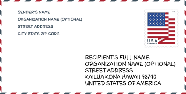
Envelope Example

This is an example of a US zip envelope. You can use a 5-digit zipcode or a detailed 9-digit zipcode to copy the mail in the following address format.
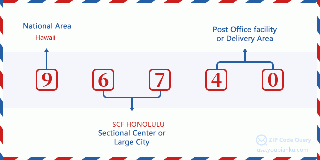
96740 Basic Meaning
What does each digit of ZIP Code 96740 stands for? The first digit designates a national area, which ranges from zero for the Northeast to nine for the far West. The 2-3 digits are the code of a sectional center facility in that region. The last two digits designate small post offices or postal zones.
Online Map

This is online map of the address Kailua Kona, Hawaii, United States. You may use button to move and zoom in / out. The map information is for reference only.
Museum

This is the ZIP Code 96740 - Museum page list. Its detail Museum Name, Street, City, State, ZIP Code, Phone is as below.
| Name | Street | City | State | ZIP Code | Phone |
| ONIZUKA SPACE CENTER | 1 KEAHOLE ST | KAILUA KONA | HI | 96740 | (808) 329-3441 |
| HULIHEE PALACE | 75-5718 ALII DR | KAILUA KONA | HI | 96740 | (808) 329-1877 |
| KALOKO-HONOKOHAU NATIONAL HISTORICAL PARK | 73-4786 KANALANI ST #14 | KAILUA-KONA | HI | 96740 | (808) 329-6881 |
Library

This is the ZIP Code 96740 - Library page list. Its detail Library Name, Address, City, State, ZIP Code, Phone is as below.
- Name: KAILUA-KONA PUBLIC LIBRARY
- Address: 75-138 HUALALAI RD.
- City: KAILUA-KONA
- State: HI - Hawaii
- ZIP Code: 96740
- Phone: (808) 327-4327
School

This is the ZIP Code 96740 - School page list. Its detail School Name, Address, City, State, ZIP Code is as below.
| School Name | Address | City | State | Grades | ZIP Code |
|---|---|---|---|---|---|
| Kealakehe Elementary School | 74-5118 Kealakaa St | Kailua-Kona | HI | UG | 96740 |
| Kahakai Elementary School | 76-147 Royal Poinciana Dr | Kailua-Kona | HI | UG | 96740 |
| Kealakehe Intermediate School | 74-5062 Onipaa St | Kailua-Kona | HI | UG | 96740 |
| Kealakehe High School | 74-5000 Puohulihuli St | Kailua-Kona | HI | UG | 96740 |
| West Hawaii Explorations Academy | 73-4500 Kahilihili St | Kailua-Kona | HI | UG | 96740 |
| Innovations - PCS | 75-5815 Queen Kaahumanu Hwy | Kailua-Kona | HI | UG | 96740 |
Population for ZIP Code 96740

What is the total population in ZIP Code 96740? Below is detail information.
- Population for ZIP Code 96740: 35,801
- 2010 Population: 33,321
The 2020 demographic statistics are in progress. The current population in ZIP code 96740 is 35,801, and the population in 2010 is 33,321.
Gender

In all the statistical population, the male population is 16,738, the female population is 16,583.
- Male Population: 16,738
- Female Population: 16,583
Race

In all the statistical population, the male population is 16,738, the female population is 16,583.
- White Population: 21,091
- Black Population: 499
- Hispanic Population: 3,570
- Asian Population: 10,691
- Hawaiian Population: 9,444
- Indian Population: 1,095
- Other Population: 1,423
Age

In all the statistical population, the White population is 21,091, the Black population is 499, the Hispanic population is 3,570, the Asian population is 10,691, the Hawaiian population is 9,444, the Indian Ppopulation is 1,095 and Other population is 1,423.
- Age's Median: 41.5
- Median of male age: 41.0
- Median of female age: 42.1
Households for ZIP Code 96740
ZIP code 96740 has 12,365 households, with an average number of 2.65 persons per household. The average income per household in Zip code 96740 is 76,296 USD, and the average house value is 512,800 USD.
- Households Per Zipcode: 12,365
- Persons Per Household: 2.65
- Average House Value: 512,800
- Income Per Household: 76,296
Geographic

The latitude of the Zip code 96740 is 19.711576, the longitude is -155.892994, and the elevation is 6609. It has land area of 236.42 square miles, and water area of 28.166 square miles. The time zone for ZIP code 96740 is Hawaii-Aleutian Islands (GMT -10:00). Daylight saving time should be observed in the area where the zip code is located.
- Latitude: 19.711576
- Longitude: -155.892994
- Elevation: 6609
- Land Area: 236.42
- Water Area: 28.166
- Time Zone: Hawaii-Aleutian Islands (GMT -10:00)
- Region: West
- Division: Pacific
- Day Light Saving: N
Congressional District

The Congressional District for ZIP code 96740 is Hawaii's 2nd congressional district, the Congressional Land Area is 6213.4 square mile.
- Congressional District: 2nd
- Congressional Land Area: 6213.4
Delivery

In the ZIP code 96740, there are 13,510 residential delivery mailboxes and centralized units, and 1,609 commercial delivery mailbox and centralized units, 7,443 single family deliveries and 2,356 multifamily deliveries, and the box count is 14,408. The main post office has city delivery carrier routes for the ZIP code 96740.
- Delivery Residential: 13,510
- Delivery Business: 1,609
- Delivery Total: 14,408
- Single Family Delivery Units: 7,443
- Multi Family Delivery Units: 2,356
- City Delivery Indicator: Y
Business

In ZIP code 96740, the number of business is 1,275, the number of employee is 18,614, the business first quarter payroll is 183,883,000 USD, the business annual payroll is 728,919,000 USD.
- Number Of Businesses: 1,275
- Number Of Employees: 18,614
- Business First Quarter Payroll: 183,883,000
- Business Annual Payroll: 728,919,000
Social Security Benefits

There are 6,270 beneficiaries with benefits in current-payment status for ZIP code 96740, of which 5,000 are retired workers, 485 are disabled workers, 325 are widow(er)s and parents, 180 are spouses and 280 are children. The number of beneficiaries aged 65 or older is 5,160. The total monthly benefits are 9,180,000 USD, of which 7,699,000 USD for retired workers, 462,000 USD for widow(er)s and parents.
- Total Number: 6,270
- Retired workers Number: 5,000
- Disabled workers Number: 485
- Widow(er)s and parents Number: 325
- Spouses Number: 180
- Children Number: 280
- All beneficiaries per month: 9,180,000
- Retired workers per month: 7,699,000
- Widow(er)s and parents per month: 462,000
- Number of beneficiaries aged 65 or older: 5,160


Add new comment