City: Post Falls, ID
This is the Post Falls ZIP Code page. Post Falls is a city name in Kootenai, Idaho, United States. The city name is designated by USPS, it could be a city, town,village school name, etc.
Basic Information

-
Country:
U.S. - United States
-
State:
ID - Idaho
-
County FIPS:
16055
-
County:
Post Falls - ZIP Code

What is the zip code of Post Falls, United States? Below is the zipcode list of Post Falls.
| ZIP Code | State | City Name | City Type ?In many cases, a ZIP Code can have multiple "names", meaning cities, towns, or subdivisions, in its boundaries. However, it will ALWAYS have exactly 1 "default" name. D - Default - This is the "preferred" name - by the USPS - for a city. Each ZIP Code has one - and only one - "default" name. In most cases, this is what people who live in that area call the city as well. A - Acceptable - This name can be used for mailing purposes. Often times alternative names are large neighborhoods or sections of the city/town. In some cases a ZIP Code may have several "acceptable" names which is used to group towns under one ZIP Code. N - Not Acceptable - A "not acceptable" name is, in many cases, a nickname that residents give that location. According to the USPS, you should NOT send mail to that ZIP Code using the "not acceptable" name when mailing. | County |
|---|---|---|---|---|
| 83854 | ID | Post Falls | D (Default) | Kootenai |
| 83877 | ID | Post Falls | D (Default) | Kootenai |
❓What does D (Default) mean? This is the "preferred" name - by the USPS - for a city. Each ZIP Code has one - and only one - "default" name. In most cases, this is what people who live in that area call the city as well.
Population

This is the population data of Post Falls in 2010 and 2020.
- City Name: Post Falls
- State: Idaho
- Population 2020: 38,145
- Population 2010: 27,921
Museum

This is the Post Falls - Museum page list. Its detail Museum Name, Street, State, ZIP Code, Phone is as below.
- Name: POST FALLS HISTORICAL SOCIETY
- Street: PO BOX 57
- City: POST FALLS
- State: ID
- ZIP Code: 83877
- Phone:
Library

This is the Post Falls - Library page list. Its detail Library Name, Address, State, ZIP Code, Phone is as below.
| Name | Address | City | State | ZIP Code | Phone |
| COMMUNITY LIBRARY NETWORK | 821 N SPOKANE ST | POST FALLS | ID | 83854 | (208) 773-1506 |
| COMMUNITY LIBRARY NETWORK - POST FALLS | 821 N SPOKANE | POST FALLS | ID | 83854 | (208) 773-1506 |
School

This is the Post Falls - School page list. Its detail School Name, Address, State, ZIP Code is as below.
| School Name | Address | City | State | Grades | ZIP Code |
| ELEVATE ACADEMY NORTH | SW CORNER KILLDEER AVENUE/BOGIE DRIVE | POST FALLS | ID | UG | 83854 |
| PRAIRIE VIEW ELEMENTARY | 2478 EAST POLELINE ROAD | POST FALLS | ID | UG | 83854 |
| FREDERICK POST KINDER CENTER | 205 WEST MULLAN | POST FALLS | ID | UG | 83877-0040 |
| PONDEROSA ELEMENTARY SCHOOL | 3483 EAST PONDEROSA BOULEVARD | POST FALLS | ID | UG | 83877-0040 |
| POST FALLS HIGH SCHOOL | 2832 EAST POLELINE ROAD | POST FALLS | ID | UG | 83877-0040 |
| POST FALLS MIDDLE SCHOOL | 301 EAST 16TH AVENUE | POST FALLS | ID | UG | 83877-0040 |
| SELTICE ELEMENTARY SCHOOL | 1100 NORTH CHASE | POST FALLS | ID | UG | 83877-0040 |
| NEW VISION HIGH SCHOOL | 205 WEST MULLAN | POST FALLS | ID | UG | 83877-0040 |
| MULLAN TRAIL ELEMENTARY SCHOOL | 300 WEST CHERRY | POST FALLS | ID | UG | 83854 |
| RIVER CITY MIDDLE SCHOOL | 1505 NORTH FIR STREET | POST FALLS | ID | UG | 83854-7844 |
| WEST RIDGE ELEMENTARY SCHOOL | 1758 NORTH CLARK FORK PARKWAY | POST FALLS | ID | UG | 83854-0040 |
| GREENSFERRY ELEMENTARY SCHOOL | 1520 NORTH BUNTING LANE | POST FALLS | ID | UG | 83854 |
| TREATY ROCK ELEMENTARY | 4916 EAST HOPE AVENUE | POST FALLS | ID | UG | 83854 |
Envelope Example

This is an example of a US zip envelope. You can use a 5-digit zipcode or a detailed 9-digit zipcode to copy the mail in the following address format.
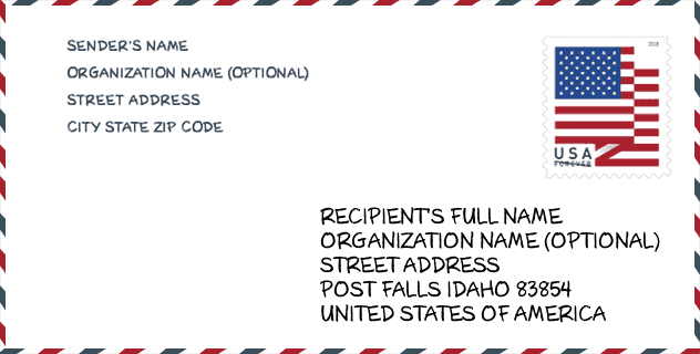
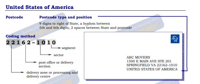
For more explanation, please read the official document: USA.pdf . (English)
Online Map

This is online map of the address Post Falls, Idaho, United States. You may use button to move and zoom in / out. The map information is for reference only.


Add new comment