United States ZIP Code: 02136
This is the Massachusetts ZIP Code 02136 page list. Its detail State, County, City, Longitude, Latitude, Envelope Example, Population is as below.
ZIP Code 02136 Information

-
-
Country:
U.S. - United States
State:
State FIPS:
25
ZIP Code:
02136
ZIP Type:
S (Standard)
❓What does S (Standard) mean? A "standard" ZIP Code is what most people think of when they talk about ZIP Codes - essentially a town, city, or a division of a city that has mail service.
ZIP Code 02136 - City

This is the city information corresponding to 02136:
| State | County | City | City Type ?In many cases, a ZIP Code can have multiple "names", meaning cities, towns, or subdivisions, in its boundaries. However, it will ALWAYS have exactly 1 "default" name. D - Default - This is the "preferred" name - by the USPS - for a city. Each ZIP Code has one - and only one - "default" name. In most cases, this is what people who live in that area call the city as well. A - Acceptable - This name can be used for mailing purposes. Often times alternative names are large neighborhoods or sections of the city/town. In some cases a ZIP Code may have several "acceptable" names which is used to group towns under one ZIP Code. N - Not Acceptable - A "not acceptable" name is, in many cases, a nickname that residents give that location. According to the USPS, you should NOT send mail to that ZIP Code using the "not acceptable" name when mailing. | ZIP Code |
|---|---|---|---|---|
| MA | Suffolk | Boston | A (Acceptable) | 02136 |
| MA | Suffolk | Hyde Park | D (Default) | 02136 |
| MA | Suffolk | Readville | A (Acceptable) | 02136 |
❓What does D (Default) mean? This is the "preferred" name - by the USPS - for a city. Each ZIP Code has one - and only one - "default" name. In most cases, this is what people who live in that area call the city as well.
❓What does A (Acceptable) mean? This name can be used for mailing purposes. Often times alternative names are large neighborhoods or sections of the city/town. In some cases a ZIP Code may have several "acceptable" names which is used to group towns under one ZIP Code.
ZIP Code 02136 Plus 4
ZIP Code 5 plus 4 is the extension of 5-digit zip code, It can be used to locate a more detailed location. The last four digits designate segment or one side of a street or an apartment. You can find the ZIP+4 code and corresponding address of the zip code 02136 below.
| ZIP Code 5 Plus 4 | Address |
|---|---|
| 02136-0001 | PO BOX 365001, HYDE PARK, MA |
| 02136-0002 | PO BOX 365061, HYDE PARK, MA |
| 02136-0003 | PO BOX 365121, HYDE PARK, MA |
| 02136-0004 | PO BOX 365181, HYDE PARK, MA |
| 02136-0005 | PO BOX 365241, HYDE PARK, MA |
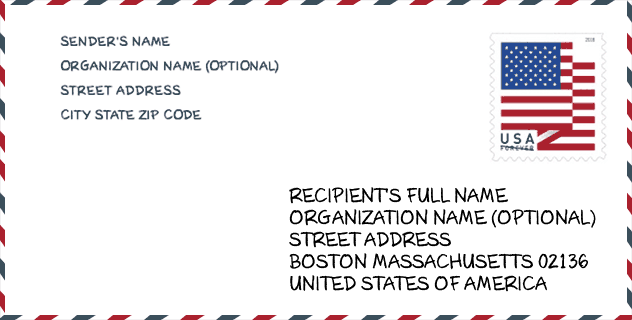
Envelope Example

This is an example of a US zip envelope. You can use a 5-digit zipcode or a detailed 9-digit zipcode to copy the mail in the following address format.
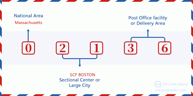
02136 Basic Meaning
What does each digit of ZIP Code 02136 stands for? The first digit designates a national area, which ranges from zero for the Northeast to nine for the far West. The 2-3 digits are the code of a sectional center facility in that region. The last two digits designate small post offices or postal zones.
Online Map

This is online map of the address Readville, Massachusetts, United States. You may use button to move and zoom in / out. The map information is for reference only.
Library

This is the ZIP Code 02136 - Library page list. Its detail Library Name, Address, City, State, ZIP Code, Phone is as below.
- Name: HYDE PARK BRANCH LIBRARY
- Address: 35 HARVARD AVENUE
- City: HYDE PARK
- State: MA - Massachusetts
- ZIP Code: 02136
- Phone: (617) 361-2524
School

This is the ZIP Code 02136 - School page list. Its detail School Name, Address, City, State, ZIP Code is as below.
| School Name | Address | City | State | Grades | ZIP Code |
|---|---|---|---|---|---|
| Academy Of the Pacific Rim Charter Public School | 1 Westinghouse Plaza | Hyde Park | MA | UG | 02136 |
| Boston Renaissance Charter Public School | 1415 Hyde Park Ave | Hyde Park | MA | UG | 02136 |
| Boston Preparatory Charter Public School | 885 River Street | Hyde Park | MA | UG | 02136 |
| Franklin D Roosevelt | 95 Needham Road | Hyde Park | MA | UG | 02136 |
| Henry Grew | 40 Gordon Avenue | Hyde Park | MA | UG | 02136 |
| William Ellery Channing | 35 Sunnyside Street | Hyde Park | MA | UG | 02136 |
| Another Course To College | 612 Metropolitan Av | Hyde Park | MA | UG | 02136 |
| New Mission High School | 655 Metropolitan Ave | Hyde Park | MA | UG | 02136 |
| Boston Community Leadership Academy | 655 Metropolitan Ave | Hyde Park | MA | UG | 02136 |
Population for ZIP Code 02136

What is the total population in ZIP Code 02136? Below is detail information.
- Population for ZIP Code 02136: 33,736
- 2010 Population: 28,488
The 2020 demographic statistics are in progress. The current population in ZIP code 02136 is 33,736, and the population in 2010 is 28,488.
Gender

In all the statistical population, the male population is 13,324, the female population is 15,164.
- Male Population: 13,324
- Female Population: 15,164
Race

In all the statistical population, the male population is 13,324, the female population is 15,164.
- White Population: 11,228
- Black Population: 14,019
- Hispanic Population: 6,351
- Asian Population: 641
- Hawaiian Population: 115
- Indian Population: 336
- Other Population: 3,463
Age

In all the statistical population, the White population is 11,228, the Black population is 14,019, the Hispanic population is 6,351, the Asian population is 641, the Hawaiian population is 115, the Indian Ppopulation is 336 and Other population is 3,463.
- Age's Median: 36.9
- Median of male age: 34.3
- Median of female age: 38.7
Households for ZIP Code 02136
ZIP code 02136 has 10,411 households, with an average number of 2.71 persons per household. The average income per household in Zip code 02136 is 64,784 USD, and the average house value is 381,900 USD.
- Households Per Zipcode: 10,411
- Persons Per Household: 2.71
- Average House Value: 381,900
- Income Per Household: 64,784
Geographic

The latitude of the Zip code 02136 is 42.252918, the longitude is -71.129278, and the elevation is 60. It has land area of 4.591 square miles, and water area of 0.11 square miles. The time zone for ZIP code 02136 is Eastern (GMT -05:00). Daylight saving time should be observed in the area where the zip code is located.
- Latitude: 42.252918
- Longitude: -71.129278
- Elevation: 60
- Land Area: 4.591
- Water Area: 0.11
- Time Zone: Eastern (GMT -05:00)
- Region: Northeast
- Division: New England
- Day Light Saving: Y
Congressional District

The Congressional District for ZIP code 02136 is Massachusetts's 07th congressional district, the Congressional Land Area is 62.67 square mile.
- Congressional District: 07th
- Congressional Land Area: 62.67
Delivery

In the ZIP code 02136, there are 12,449 residential delivery mailboxes and centralized units, and 728 commercial delivery mailbox and centralized units, 9,780 single family deliveries and 2,342 multifamily deliveries, and the box count is 14,095. The main post office has city delivery carrier routes for the ZIP code 02136.
- Delivery Residential: 12,449
- Delivery Business: 728
- Delivery Total: 14,095
- Single Family Delivery Units: 9,780
- Multi Family Delivery Units: 2,342
- City Delivery Indicator: Y
Business

In ZIP code 02136, the number of business is 437, the number of employee is 5,399, the business first quarter payroll is 62,929,000 USD, the business annual payroll is 253,189,000 USD.
- Number Of Businesses: 437
- Number Of Employees: 5,399
- Business First Quarter Payroll: 62,929,000
- Business Annual Payroll: 253,189,000


Add new comment