Postcode: 99695, Anchorage, AK
Postcode 99695 bevindt zich in Anchorage, Alaska. Het detail staat, provincie, stad, lengtegraad, breedtegraad, envelop Voorbeeld, Bevolking is zoals hieronder.
Postcode 99695 Informatie

-
-
Land:
U.S. - Verenigde Staten
Staat:
Regio FIPS:
02020
Graafschap:
Stad:
Netnummer:
Stadtype ?In many cases, a ZIP Code can have multiple "names", meaning cities, towns, or subdivisions, in its boundaries. However, it will ALWAYS have exactly 1 "default" name. D - Default - This is the "preferred" name - by the USPS - for a city. Each ZIP Code has one - and only one - "default" name. In most cases, this is what people who live in that area call the city as well. A - Acceptable - This name can be used for mailing purposes. Often times alternative names are large neighborhoods or sections of the city/town. In some cases a ZIP Code may have several "acceptable" names which is used to group towns under one ZIP Code. N - Not Acceptable - A "not acceptable" name is, in many cases, a nickname that residents give that location. According to the USPS, you should NOT send mail to that ZIP Code using the "not acceptable" name when mailing.:
D (Default)
Postcode:
99695
❓Wat betekent D (Default)? Dit is de "geprefereerde" naam - door de USPS - voor een stad. Elke postcode heeft één - en slechts één - "standaard" naam. In de meeste gevallen noemen mensen die in dat gebied wonen de stad ook.
Postcode 99695 Plus 4
ZIP Code 5 plus 4 is de uitbreiding van de 5-cijferige postcode, het kan worden gebruikt om een meer gedetailleerde locatie te vinden. De laatste vier cijfers duiden een segment of een kant van een straat of een appartement aan. Hieronder vindt u de postcode en het bijbehorende adres van de postcode 99695.
| Postcode 5 Plus 4 | Adres |
|---|---|
| 99695-0020 | PO BOX 0, ANCHORAGE, AK |
| 99695-0050 | PO BOX 0, ANCHORAGE, AK |
| 99695-0100 | PO BOX 0, ANCHORAGE, AK |
| 99695-9998 | PO BOX 0, ANCHORAGE, AK |
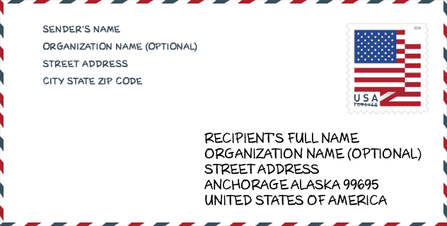
Envelop Voorbeeld

Dit is een voorbeeld van een Amerikaanse postenvelop. U kunt een 5-cijferige postcode of een gedetailleerde 9-cijferige postcode gebruiken om de mail in het volgende adresformaat te kopiëren.
99695 Basisbetekenis
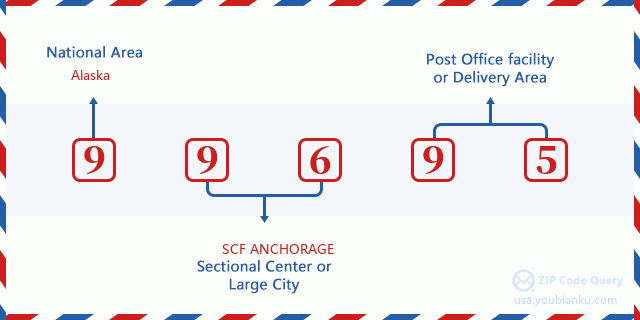
Waar staat elk cijfer van postcode 99695 voor? Het eerste cijfer geeft een nationaal gebied aan, dat varieert van nul voor het noordoosten tot negen voor het verre westen. De 2-3 cijfers zijn de code van een sectiecentrumfaciliteit in die regio. De laatste twee cijfers duiden kleine postkantoren of postzones aan.
Online landkaart

Het is een online kaart van adres Anchorage, Alaska, United States. U kunt Knopje gebruiken te in/uitzoomen. De kaartinformatie is alleen ter referentie.
Geslacht

In all the statistical population, the male population is 4, the female population is 3.
- Male Population: 4
- Female Population: 3
Race

In all the statistical population, the male population is 4, the female population is 3.
- White Population: 0
- Black Population: 0
- Hispanic Population: 0
- Asian Population: 0
- Hawaiian Population: 0
- Indian Population: 7
- Other Population: 0
Leeftijd

In all the statistical population, the White population is 0, the Black population is 0, the Hispanic population is 0, the Asian population is 0, the Hawaiian population is 0, the Indian Ppopulation is 7 and Other population is 0.
- Age's Median: 57.3
- Median of male age: 41.0
- Median of female age: 57.5
Households for Postcode 99695
ZIP code 99695 has 2 households, with an average number of 3.50 persons per household. The average income per household in Zip code 99695 is 0 USD, and the average house value is 0 USD.
- Households Per Zipcode: 2
- Personen per huishouden: 3.50
- Gemiddelde huiswaarde: 0
- Inkomen per huishouden: 0
Geographic

The latitude of the Zip code 99695 is 61.218100, the longitude is -149.900400, and the elevation is 102. It has land area of 4.193 square miles, and water area of 0 square miles. The time zone for ZIP code 99695 is Alaska (GMT -09:00). Daylight saving time should be observed in the area where the zip code is located.
- Breedtegraad: 61.218100
- Lengte: -149.900400
- Elevatie: 102
- Landoppervlak: 4.193
- Water Area: 0
- Tijd Zone: Alaska (GMT -09:00)
- Regio: West
- Divisie: Pacific
- Zomertijd: Y
congresdistrict

ZIP code 99695 belongs to Alaska, Alaska has been entitled to one member in the United States House of Representatives, elected in the state's sole, at-large congressional district. The congressional land area is 571951.26 square mile.
- congresdistrict: Geen
- Congresgebied: 571951.26
Levering

In the ZIP code 99695, there are 0 residential delivery mailboxes and centralized units, and 0 commercial delivery mailbox and centralized units, 0 single family deliveries and 0 multifamily deliveries, and the box count is 2. The main post office does not have city delivery carrier routes for the ZIP code 99695.
- Delivery Residential: 0
- Delivery Business: 0
- Delivery Total: 2
- Leveringseenheden voor één gezin: 0
- Multi Family Delivery Units: 0
- Stadsleveringsindicator: N


Reactie toevoegen