Verenigde Staten Postcode: 10010
Dit is de paginalijst van New York Postcode 10010. Hieronder is het detail van Staat, Graafschap, Stad, Lengte, Breedtegraad, Envelop Voorbeeld, Bevolking.

Postcode 10010 Informatie

-
-
Land:
U.S. - Verenigde Staten
Staat:
Staat FIPS:
36
Postcode:
10010
Postcode Type:
S (Standard)
❓Wat betekent S (Standard)? Een "standaard" postcode is waar de meeste mensen aan denken als ze het over postcodes hebben - in wezen een stad, een stad of een afdeling van een stad die een postdienst heeft.
Postcode 10010 - Stad

Dit is de stadsinformatie die overeenkomt met 10010:
| Staat | Graafschap | Stad | Stadtype ?In many cases, a ZIP Code can have multiple "names", meaning cities, towns, or subdivisions, in its boundaries. However, it will ALWAYS have exactly 1 "default" name. D - Default - This is the "preferred" name - by the USPS - for a city. Each ZIP Code has one - and only one - "default" name. In most cases, this is what people who live in that area call the city as well. A - Acceptable - This name can be used for mailing purposes. Often times alternative names are large neighborhoods or sections of the city/town. In some cases a ZIP Code may have several "acceptable" names which is used to group towns under one ZIP Code. N - Not Acceptable - A "not acceptable" name is, in many cases, a nickname that residents give that location. According to the USPS, you should NOT send mail to that ZIP Code using the "not acceptable" name when mailing. | Postcode |
|---|---|---|---|---|
| NY | New York | Madison Square | N (Not Acceptable) | 10010 |
| NY | New York | Manhattan | N (Not Acceptable) | 10010 |
| NY | New York | New York | D (Default) | 10010 |
| NY | New York | New York City | N (Not Acceptable) | 10010 |
| NY | New York | Ny | N (Not Acceptable) | 10010 |
| NY | New York | Ny City | N (Not Acceptable) | 10010 |
| NY | New York | Nyc | N (Not Acceptable) | 10010 |
❓Wat betekent D (Default)? Dit is de "geprefereerde" naam - door de USPS - voor een stad. Elke postcode heeft één - en slechts één - "standaard" naam. In de meeste gevallen noemen mensen die in dat gebied wonen de stad ook.
❓Wat betekent N (Not Acceptable)? Een "niet acceptabele" naam is in veel gevallen een bijnaam die bewoners aan die locatie geven. Volgens de USPS mag je GEEN post naar die postcode sturen met de "niet acceptabele" naam bij het mailen.
Postcode 10010 Plus 4
ZIP Code 5 plus 4 is de uitbreiding van de 5-cijferige postcode, het kan worden gebruikt om een meer gedetailleerde locatie te vinden. De laatste vier cijfers duiden een segment of een kant van een straat of een appartement aan. Hieronder vindt u de postcode en het bijbehorende adres van de postcode 10010.
| Postcode 5 Plus 4 | Adres |
|---|---|
| 10010-0001 | 61 GRAMERCY PARK #00000701 , NEW YORK, NY |
| 10010-0002 | 60 W 23RD ST #00001005 , NEW YORK, NY |
| 10010-0003 | 1123 BROADWAY #00000314 , NEW YORK, NY |
| 10010-1001 | 55 W 26TH ST #00000001 , NEW YORK, NY |
| 10010-1001 | 55 W 26TH ST, NEW YORK, NY |
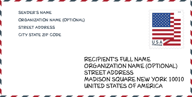
Envelop Voorbeeld

Dit is een voorbeeld van een Amerikaanse postenvelop. U kunt een 5-cijferige postcode of een gedetailleerde 9-cijferige postcode gebruiken om de mail in het volgende adresformaat te kopiëren.
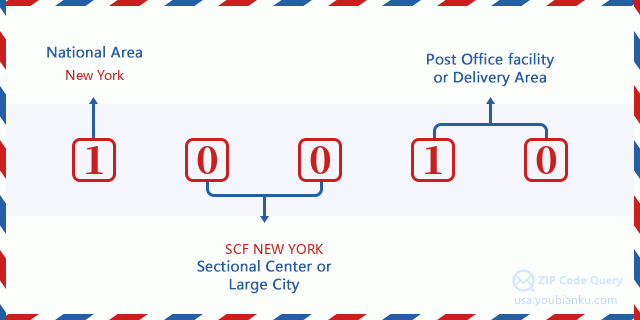
10010 Basisbetekenis
Waar staat elk cijfer van postcode 10010 voor? Het eerste cijfer geeft een nationaal gebied aan, dat varieert van nul voor het noordoosten tot negen voor het verre westen. De 2-3 cijfers zijn de code van een sectiecentrumfaciliteit in die regio. De laatste twee cijfers duiden kleine postkantoren of postzones aan.
Online landkaart

Het is een online kaart van adres Nyc, New York, United States. U kunt Knopje gebruiken te in/uitzoomen. De kaartinformatie is alleen ter referentie.
Universiteit

This is the ZIP Code 10010 - University page list. Its detail university Name, Street, City, State, ZIP Code, Phone is as below.
| Naam | Straat | Stad | Staat | Postcode | Telefoon |
| CUNY Bernard M Baruch College | One Bernard Baruch Way (55 Lexington Ave at 24th St) | New York | NY | 10010 | (646) 312-1000 |
| Institute of Culinary Education | 50 W 23rd St | New York | NY | 10010 | - |
| School of Visual Arts | 209 E 23rd St | New York | NY | 10010 | (212) 592-2000 |
| Touro College | 27-33 W 23rd St | New York | NY | 10010 | - |
Museum

Dit is de paginalijst van Postcode 10010 - Museum. Hieronder is het detail van Museum Naam, Straat, Stad, Staat, Postcode, Telefoon.
| Naam | Straat | Stad | Staat | Postcode | Telefoon |
| CHANCELLOR ROBERT R LIVINGSTON MASONIC LIBRARY | 71 W 23RD ST 14TH FLR | NEW YORK | NY | 10010 | (212) 337-6619 |
| SIDNEY MISHKIN GALLERY | 135 EAST 22ND STREET | NEW YORK | NY | 10010 | (212) 802-2690 |
| SVA CHELSEA GALLERY | 601 WEST 26TH ST | NEW YORK | NY | 10010 | (212) 592-2145 |
Bibliotheek

Dit is de paginalijst van Postcode 10010 - Bibliotheek. Hieronder is het detail van Bibliotheek Naam, Adres, Stad, Staat, Postcode, Telefoon.
- Naam: EPIPHANY BRANCH
- Adres: 228 EAST 23RD STREET
- Stad: NEW YORK
- Staat: NY - New York
- Postcode: 10010
- Telefoon: (212) 679-2645
School
Dit is de paginalijst van Postcode 10010 - School. Hieronder is het detail van School Naam, Adres, Stad, Staat, Postcode.
| School Naam | Adres | Stad | Staat | Klassen | Postcode |
|---|---|---|---|---|---|
| BARUCH COLLEGE CAMPUS HIGH SCHOOL | 55 E 25TH ST | NEW YORK | NY | UG | 10010 |
| SCHOOL OF THE FUTURE HIGH SCHOOL | 127 E 22ND ST | NEW YORK | NY | UG | 10010 |
| AMERICAN SIGN LANGUAGE & ENGLISH SECONDARY SCHOOL | 223 E 23RD ST | NEW YORK | NY | UG | 10010 |
| 47 AMERICAN SIGN LANGUAGE AND ENGLISH LOWER SCHOOL (THE) | 223 E 23RD ST | NEW YORK | NY | UG | 10010 |
Population for Postcode 10010

What is the total population in ZIP Code 10010? Below is detail information.
- Population for Postcode 10010: 32,239
- 2010 Bevolking: 31,834
The 2020 demographic statistics are in progress. The current population in ZIP code 10010 is 32,239, and the population in 2010 is 31,834.
Geslacht

In all the statistical population, the male population is 14,755, the female population is 17,079.
- Male Population: 14,755
- Female Population: 17,079
Race

In all the statistical population, the male population is 14,755, the female population is 17,079.
- White Population: 24,326
- Black Population: 2,212
- Hispanic Population: 3,015
- Asian Population: 5,154
- Hawaiian Population: 59
- Indian Population: 194
- Other Population: 995
Leeftijd

In all the statistical population, the White population is 24,326, the Black population is 2,212, the Hispanic population is 3,015, the Asian population is 5,154, the Hawaiian population is 59, the Indian Ppopulation is 194 and Other population is 995.
- Age's Median: 33.3
- Median of male age: 34.6
- Median of female age: 32.1
Households for Postcode 10010
ZIP code 10010 has 16,556 households, with an average number of 1.68 persons per household. The average income per household in Zip code 10010 is 117,923 USD, and the average house value is 788,200 USD.
- Households Per Zipcode: 16,556
- Personen per huishouden: 1.68
- Gemiddelde huiswaarde: 788,200
- Inkomen per huishouden: 117,923
Geographic

The latitude of the Zip code 10010 is 40.738634, the longitude is -73.982937, and the elevation is 25. It has land area of 0.382 square miles, and water area of 0 square miles. The time zone for ZIP code 10010 is Eastern (GMT -05:00). Daylight saving time should be observed in the area where the zip code is located.
- Breedtegraad: 40.738634
- Lengte: -73.982937
- Elevatie: 25
- Landoppervlak: 0.382
- Water Area: 0
- Tijd Zone: Eastern (GMT -05:00)
- Regio: Northeast
- Divisie: Middle Atlantic
- Zomertijd: Y
congresdistrict

The Congressional District for ZIP code 10010 is New York's 12th congressional district, the Congressional Land Area is 14.79 square mile.
- congresdistrict: 12th
- Congresgebied: 14.79
Levering

In the ZIP code 10010, there are 19,190 residential delivery mailboxes and centralized units, and 2,795 commercial delivery mailbox and centralized units, 80 single family deliveries and 19,110 multifamily deliveries, and the box count is 22,085. The main post office has city delivery carrier routes for the ZIP code 10010.
- Delivery Residential: 19,190
- Delivery Business: 2,795
- Delivery Total: 22,085
- Leveringseenheden voor één gezin: 80
- Multi Family Delivery Units: 19,110
- Stadsleveringsindicator: Y
Bedrijf

In ZIP code 10010, the number of business is 2,924, the number of employee is 73,268, the business first quarter payroll is 2,748,163,000 USD, the business annual payroll is 8,862,128,000 USD.
- Number Of Businesses: 2,924
- Number Of Employees: 73,268
- Zakelijke salarisadministratie eerste kwartaal: 2,748,163,000
- Zakelijke jaarlijkse loonlijst: 8,862,128,000
Sociale zekerheid

Er zijn 4,235 begunstigden met uitkeringen in de huidige betalingsstatus voor postcode 10010, waarvan 3,535 gepensioneerde werknemers, 280 gehandicapte werknemers, 155 weduwnaar (eren) en ouders, 160 zijn echtgenoten en 105 zijn kinderen. Het aantal begunstigden van 65 jaar of ouder is 3,795. De totale maandelijkse uitkeringen bedragen 7,791,000 USD, waarvan 6,897,000 USD voor gepensioneerde werknemers, 260,000 USD voor weduwnaar (eren) en ouders.
- Totaal aantal: 4,235
- Aantal gepensioneerden: 3,535
- Aantal gehandicapte werknemers: 280
- Weduwe / weduwnaar (er) en ouders Aantal: 155
- Echtgenoten nummer: 160
- Aantal kinderen: 105
- Alle begunstigden per maand: 7,791,000
- Gepensioneerde werknemers per maand: 6,897,000
- Weduwe (n) en ouders per maand: 260,000
- Aantal begunstigden van 65 jaar of ouder: 3,795


Reactie toevoegen