United States ZIP Code: 44004
This is the Ohio ZIP Code 44004 page list. Its detail State, County, City, Longitude, Latitude, Envelope Example, Population is as below.

ZIP Code 44004 Information

ZIP Code 44004 - City

This is the city information corresponding to 44004:
| State | County | City | City Type ?In many cases, a ZIP Code can have multiple "names", meaning cities, towns, or subdivisions, in its boundaries. However, it will ALWAYS have exactly 1 "default" name. D - Default - This is the "preferred" name - by the USPS - for a city. Each ZIP Code has one - and only one - "default" name. In most cases, this is what people who live in that area call the city as well. A - Acceptable - This name can be used for mailing purposes. Often times alternative names are large neighborhoods or sections of the city/town. In some cases a ZIP Code may have several "acceptable" names which is used to group towns under one ZIP Code. N - Not Acceptable - A "not acceptable" name is, in many cases, a nickname that residents give that location. According to the USPS, you should NOT send mail to that ZIP Code using the "not acceptable" name when mailing. | ZIP Code |
|---|---|---|---|---|
| OH | Ashtabula | Ashtabula | D (Default) | 44004 |
| OH | Ashtabula | E Ashtabula | N (Not Acceptable) | 44004 |
| OH | Ashtabula | East Ashtabula | N (Not Acceptable) | 44004 |
| OH | Ashtabula | Edgewood | N (Not Acceptable) | 44004 |
| OH | Ashtabula | Plymouth Twp | N (Not Acceptable) | 44004 |
❓What does D (Default) mean? This is the "preferred" name - by the USPS - for a city. Each ZIP Code has one - and only one - "default" name. In most cases, this is what people who live in that area call the city as well.
❓What does N (Not Acceptable) mean? A "not acceptable" name is, in many cases, a nickname that residents give that location. According to the USPS, you should NOT send mail to that ZIP Code using the "not acceptable" name when mailing.
ZIP Code 44004 Plus 4
ZIP Code 5 plus 4 is the extension of 5-digit zip code, It can be used to locate a more detailed location. The last four digits designate segment or one side of a street or an apartment. You can find the ZIP+4 code and corresponding address of the zip code 44004 below.
| ZIP Code 5 Plus 4 | Address |
|---|---|
| 44004-2000 | 1201 CHESTNUT DR, ASHTABULA, OH |
| 44004-2001 | 5147 LAKE RD, ASHTABULA, OH |
| 44004-2002 | 1 ARCOLA DR, ASHTABULA, OH |
| 44004-2003 | 1101 CHESTNUT DR, ASHTABULA, OH |
| 44004-2004 | 1100 CHESTNUT DR, ASHTABULA, OH |
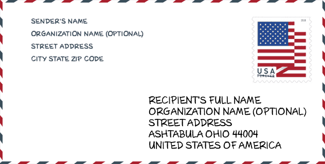
Envelope Example

This is an example of a US zip envelope. You can use a 5-digit zipcode or a detailed 9-digit zipcode to copy the mail in the following address format.
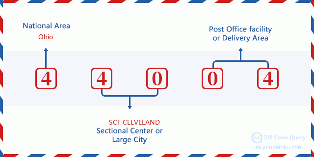
44004 Basic Meaning
What does each digit of ZIP Code 44004 stands for? The first digit designates a national area, which ranges from zero for the Northeast to nine for the far West. The 2-3 digits are the code of a sectional center facility in that region. The last two digits designate small post offices or postal zones.
Online Map

This is online map of the address Plymouth Twp, Ohio, United States. You may use button to move and zoom in / out. The map information is for reference only.
University

This is the ZIP Code 44004 - University page list. Its detail university Name, Street, City, State, ZIP Code, Phone is as below.
| Name | Street | City | State | ZIP Code | Phone |
| Kent State University at Ashtabula | 3300 Lake Road West | Ashtabula | OH | 44004 | (440) 964-3322 |
Hospital

This is the ZIP Code 44004 - Hospital page list. Its detail Hospital Name, Street, City, State, ZIP Code, Phone is as below.
- Name: ASHTABULA COUNTY MEDICAL CENTER
- Address: ASHTABULA
- City: 2420 LAKE AVENUE
- State: OH
- ZIP Code: 44004
- Phone: (440) 997-2262
Museum

This is the ZIP Code 44004 - Museum page list. Its detail Museum Name, Street, City, State, ZIP Code, Phone is as below.
| Name | Street | City | State | ZIP Code | Phone |
| FINNISH AMERICAN HERITAGE AND MUSEUM | 1330 W 8TH ST | ASHTABULA | OH | 44004 | (440) 964-5790 |
| ASHTABULA MARINE MUSEUM | 1071 WALNUT BLVD | ASHTABULA | OH | 44004 | (440) 964-6847 |
Library

This is the ZIP Code 44004 - Library page list. Its detail Library Name, Address, City, State, ZIP Code, Phone is as below.
| Name | Address | City | State | ZIP Code | Phone |
|---|---|---|---|---|---|
| ASHTABULA COUNTY DISTRICT LIBRARY | 4335 PARK AVE | ASHTABULA | OH | 44004 | (440) 997-9341 |
| HARBOR-TOPKY MEMORIAL LIBRARY | 1633 WALNUT BLVD. | ASHTABULA HARBOR | OH | 44004 | (440) 964-9645 |
Population for ZIP Code 44004

What is the total population in ZIP Code 44004? Below is detail information.
- Population for ZIP Code 44004: 33,725
- 2010 Population: 33,421
The 2020 demographic statistics are in progress. The current population in ZIP code 44004 is 33,725, and the population in 2010 is 33,421.
Gender

In all the statistical population, the male population is 16,081, the female population is 17,340.
- Male Population: 16,081
- Female Population: 17,340
Race

In all the statistical population, the male population is 16,081, the female population is 17,340.
- White Population: 30,310
- Black Population: 2,829
- Hispanic Population: 2,151
- Asian Population: 229
- Hawaiian Population: 40
- Indian Population: 371
- Other Population: 918
Age

In all the statistical population, the White population is 30,310, the Black population is 2,829, the Hispanic population is 2,151, the Asian population is 229, the Hawaiian population is 40, the Indian Ppopulation is 371 and Other population is 918.
- Age's Median: 41.1
- Median of male age: 40.2
- Median of female age: 42.0
Households for ZIP Code 44004
ZIP code 44004 has 13,791 households, with an average number of 2.39 persons per household. The average income per household in Zip code 44004 is 37,933 USD, and the average house value is 88,100 USD.
- Households Per Zipcode: 13,791
- Persons Per Household: 2.39
- Average House Value: 88,100
- Income Per Household: 37,933
Geographic

The latitude of the Zip code 44004 is 41.851980, the longitude is -80.790472, and the elevation is 764. It has land area of 72.374 square miles, and water area of 5.517 square miles. The time zone for ZIP code 44004 is Eastern (GMT -05:00). Daylight saving time should be observed in the area where the zip code is located.
- Latitude: 41.851980
- Longitude: -80.790472
- Elevation: 764
- Land Area: 72.374
- Water Area: 5.517
- Time Zone: Eastern (GMT -05:00)
- Region: Midwest
- Division: East North Central
- Day Light Saving: Y
Congressional District

The Congressional District for ZIP code 44004 is Ohio's 14th congressional district, the Congressional Land Area is 1953.14 square mile.
- Congressional District: 14th
- Congressional Land Area: 1953.14
Delivery

In the ZIP code 44004, there are 14,111 residential delivery mailboxes and centralized units, and 888 commercial delivery mailbox and centralized units, 12,176 single family deliveries and 958 multifamily deliveries, and the box count is 15,040. The main post office has city delivery carrier routes for the ZIP code 44004.
- Delivery Residential: 14,111
- Delivery Business: 888
- Delivery Total: 15,040
- Single Family Delivery Units: 12,176
- Multi Family Delivery Units: 958
- City Delivery Indicator: Y
Business

In ZIP code 44004, the number of business is 697, the number of employee is 10,946, the business first quarter payroll is 106,469,000 USD, the business annual payroll is 435,161,000 USD.
- Number Of Businesses: 697
- Number Of Employees: 10,946
- Business First Quarter Payroll: 106,469,000
- Business Annual Payroll: 435,161,000
Social Security Benefits

There are 7,890 beneficiaries with benefits in current-payment status for ZIP code 44004, of which 4,890 are retired workers, 1,600 are disabled workers, 545 are widow(er)s and parents, 245 are spouses and 610 are children. The number of beneficiaries aged 65 or older is 5,365. The total monthly benefits are 9,755,000 USD, of which 6,745,000 USD for retired workers, 705,000 USD for widow(er)s and parents.
- Total Number: 7,890
- Retired workers Number: 4,890
- Disabled workers Number: 1,600
- Widow(er)s and parents Number: 545
- Spouses Number: 245
- Children Number: 610
- All beneficiaries per month: 9,755,000
- Retired workers per month: 6,745,000
- Widow(er)s and parents per month: 705,000
- Number of beneficiaries aged 65 or older: 5,365


Add new comment