ZIP Code: 02860, Pawtucket, RI
ZIP Code 02860 is located in Pawtucket, Rhode Island. Its detail State, County, City, Longitude, Latitude, Envelope Example, Population is as below.
ZIP Code 02860 Information

-
-
Country:
U.S. - United States
State:
County FIPS:
44007
City:
Area Code:
City Type ?In many cases, a ZIP Code can have multiple "names", meaning cities, towns, or subdivisions, in its boundaries. However, it will ALWAYS have exactly 1 "default" name. D - Default - This is the "preferred" name - by the USPS - for a city. Each ZIP Code has one - and only one - "default" name. In most cases, this is what people who live in that area call the city as well. A - Acceptable - This name can be used for mailing purposes. Often times alternative names are large neighborhoods or sections of the city/town. In some cases a ZIP Code may have several "acceptable" names which is used to group towns under one ZIP Code. N - Not Acceptable - A "not acceptable" name is, in many cases, a nickname that residents give that location. According to the USPS, you should NOT send mail to that ZIP Code using the "not acceptable" name when mailing.:
D (Default)
ZIP Code:
02860
❓What does D (Default) mean? This is the "preferred" name - by the USPS - for a city. Each ZIP Code has one - and only one - "default" name. In most cases, this is what people who live in that area call the city as well.
ZIP Code 02860 Plus 4
ZIP Code 5 plus 4 is the extension of 5-digit zip code, It can be used to locate a more detailed location. The last four digits designate segment or one side of a street or an apartment. You can find the ZIP+4 code and corresponding address of the zip code 02860 below.
| ZIP Code 5 Plus 4 | Address |
|---|---|
| 02860-0001 | PO BOX 1, PAWTUCKET, RI |
| 02860-1000 | 300 FRONT ST, PAWTUCKET, RI |
| 02860-1001 | 55 BLACKSTONE AVE, PAWTUCKET, RI |
| 02860-1002 | 1 CARNATION ST, PAWTUCKET, RI |
| 02860-1003 | 2 CARNATION ST, PAWTUCKET, RI |
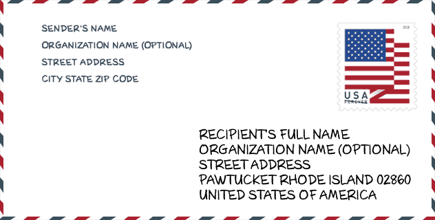
Envelope Example

This is an example of a US zip envelope. You can use a 5-digit zipcode or a detailed 9-digit zipcode to copy the mail in the following address format.
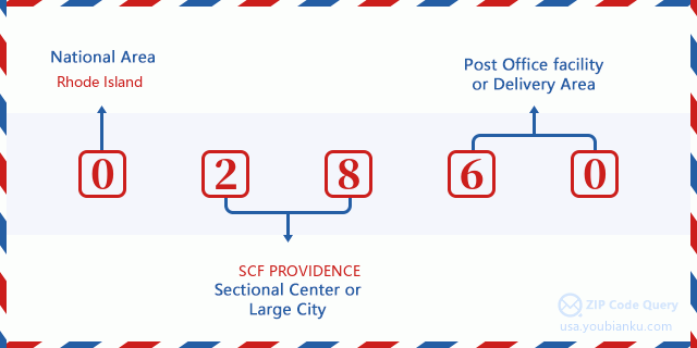
02860 Basic Meaning
What does each digit of ZIP Code 02860 stands for? The first digit designates a national area, which ranges from zero for the Northeast to nine for the far West. The 2-3 digits are the code of a sectional center facility in that region. The last two digits designate small post offices or postal zones.
Online Map

This is online map of the address Pawtucket, Rhode Island, United States. You may use button to move and zoom in / out. The map information is for reference only.
University

This is the ZIP Code 02860 - University page list. Its detail university Name, Street, City, State, ZIP Code, Phone is as below.
| Name | Street | City | State | ZIP Code | Phone |
| New England Tractor Trailer Training School of Rhode Island | 600 Moshassuck Valley Industrial Hwy | Pawtucket | RI | 02860 | (401) 725-1220 |
| Newport School of Hairdressing-Main Campus | 226 Main St | Pawtucket | RI | 02860 | - |
Library

This is the ZIP Code 02860 - Library page list. Its detail Library Name, Address, City, State, ZIP Code, Phone is as below.
| Name | Address | City | State | ZIP Code | Phone |
|---|---|---|---|---|---|
| PAWTUCKET PUBLIC LIBRARY | 13 SUMMER STREET | PAWTUCKET | RI | 02860 | (401) 725-3714 |
| PAWTUCKET PUBLIC LIBRARY BOOKMOBILE | 13 SUMMER STREET | PAWTUCKET | RI | 02860 | (401) 725-3714 |
School
This is the ZIP Code 02860 - School page list. Its detail School Name, Address, City, State, ZIP Code is as below.
| School Name | Address | City | State | Grades | ZIP Code |
|---|---|---|---|---|---|
| International Charter School | 334 Pleasant Street | Pawtucket | RI | UG | 02860 |
| Blackstone Academy Charter | 334 Pleasant Street | Pawtucket | RI | UG | 02860 |
| Agnes E. Little School | 60 South Bend Street | Pawtucket | RI | UG | 02860 |
| Cunningham School | 40 Baldwin Street | Pawtucket | RI | UG | 02860 |
| Elizabeth Baldwin School | 50 Whitman Street | Pawtucket | RI | UG | 02860 |
| Francis J. Varieur School | 486 Pleasant Street | Pawtucket | RI | UG | 02860 |
| Henry J. Winters School | 723 Central Avenue | Pawtucket | RI | UG | 02860 |
| Joseph Jenks Middle School | 350 Division Street | Pawtucket | RI | UG | 02860 |
| Samuel Slater Middle School | 281 Mineral Spring Avenue | Pawtucket | RI | UG | 02860 |
| Charles E. Shea High School | 485 East Avenue | Pawtucket | RI | UG | 02860 |
| William E. Tolman High | 150 Exchange Street | Pawtucket | RI | UG | 02860 |
| Jacqueline M. Walsh School | 350 Divison Street | Pawtucket | RI | UG | 02860 |
Population for ZIP Code 02860

What is the total population in ZIP Code 02860? Below is detail information.
- Population for ZIP Code 02860: 45,441
- 2010 Population: 45,199
The 2020 demographic statistics are in progress. The current population in ZIP code 02860 is 45,441, and the population in 2010 is 45,199.
Gender

In all the statistical population, the male population is 21,577, the female population is 23,622.
- Male Population: 21,577
- Female Population: 23,622
Race

In all the statistical population, the male population is 21,577, the female population is 23,622.
- White Population: 27,453
- Black Population: 10,288
- Hispanic Population: 10,837
- Asian Population: 1,024
- Hawaiian Population: 311
- Indian Population: 722
- Other Population: 9,164
Age

In all the statistical population, the White population is 27,453, the Black population is 10,288, the Hispanic population is 10,837, the Asian population is 1,024, the Hawaiian population is 311, the Indian Ppopulation is 722 and Other population is 9,164.
- Age's Median: 34.7
- Median of male age: 33.3
- Median of female age: 36.1
Households for ZIP Code 02860
ZIP code 02860 has 18,421 households, with an average number of 2.43 persons per household. The average income per household in Zip code 02860 is 41,638 USD, and the average house value is 179,400 USD.
- Households Per Zipcode: 18,421
- Persons Per Household: 2.43
- Average House Value: 179,400
- Income Per Household: 41,638
Geographic

The latitude of the Zip code 02860 is 41.875246, the longitude is -71.394510, and the elevation is 101. It has land area of 5.404 square miles, and water area of 0.303 square miles. The time zone for ZIP code 02860 is Eastern (GMT -05:00). Daylight saving time should be observed in the area where the zip code is located.
- Latitude: 41.875246
- Longitude: -71.394510
- Elevation: 101
- Land Area: 5.404
- Water Area: 0.303
- Time Zone: Eastern (GMT -05:00)
- Region: Northeast
- Division: New England
- Day Light Saving: Y
Congressional District

The Congressional District for ZIP code 02860 is Rhode Island's 1st congressional district, the Congressional Land Area is 268.49 square mile.
- Congressional District: 1st
- Congressional Land Area: 268.49
Delivery

In the ZIP code 02860, there are 18,700 residential delivery mailboxes and centralized units, and 1,564 commercial delivery mailbox and centralized units, 12,626 single family deliveries and 4,358 multifamily deliveries, and the box count is 20,103. The main post office has city delivery carrier routes for the ZIP code 02860.
- Delivery Residential: 18,700
- Delivery Business: 1,564
- Delivery Total: 20,103
- Single Family Delivery Units: 12,626
- Multi Family Delivery Units: 4,358
- City Delivery Indicator: Y
Business

In ZIP code 02860, the number of business is 1,015, the number of employee is 13,764, the business first quarter payroll is 132,394,000 USD, the business annual payroll is 524,082,000 USD.
- Number Of Businesses: 1,015
- Number Of Employees: 13,764
- Business First Quarter Payroll: 132,394,000
- Business Annual Payroll: 524,082,000


Add new comment