Poskod: 36723, Boykin, AL
Poskod 36723 terletak di Boykin, Alabama. Butirannya Negeri, Kaunti, Bandar, Longitud, Latitud, Contoh Sampul Surat, Penduduk adalah seperti di bawah.

Poskod 36723 Maklumat

-
-
Negara:
U.S. - Amerika Syarikat
Negeri:
FIPS Daerah:
01131
Kaunti:
Bandar:
Kod Kawasan:
Jenis Bandar ?In many cases, a ZIP Code can have multiple "names", meaning cities, towns, or subdivisions, in its boundaries. However, it will ALWAYS have exactly 1 "default" name. D - Default - This is the "preferred" name - by the USPS - for a city. Each ZIP Code has one - and only one - "default" name. In most cases, this is what people who live in that area call the city as well. A - Acceptable - This name can be used for mailing purposes. Often times alternative names are large neighborhoods or sections of the city/town. In some cases a ZIP Code may have several "acceptable" names which is used to group towns under one ZIP Code. N - Not Acceptable - A "not acceptable" name is, in many cases, a nickname that residents give that location. According to the USPS, you should NOT send mail to that ZIP Code using the "not acceptable" name when mailing.:
D (Default)
Poskod:
36723
❓Apa maksud D (Default)? Ini adalah nama "pilihan" - oleh USPS - untuk sebuah bandar. Setiap Poskod mempunyai satu - dan hanya satu - "lalai" nama. Dalam kebanyakan kes, inilah yang dinamakan orang yang tinggal di kawasan itu juga sebagai bandar.
Poskod 36723 Plus 4
Poskod 5 tambah 4 ialah lanjutan kod pos 5 digit, Ia boleh digunakan untuk mencari lokasi yang lebih terperinci. Empat digit terakhir menandakan segmen atau satu sisi jalan atau apartmen. Anda boleh mencari kod ZIP+4 dan alamat poskod 36723 yang sepadan di bawah.
| Poskod 5 Plus 4 | Alamat |
|---|---|
| 36723-0001 | PO BOX 1, BOYKIN, AL |
| 36723-0061 | PO BOX 61, BOYKIN, AL |
| 36723-0121 | PO BOX 121, BOYKIN, AL |
| 36723-2500 | 14000 COUNTY ROAD 29, BOYKIN, AL |
| 36723-9998 | 14030 COUNTY ROAD 29, BOYKIN, AL |
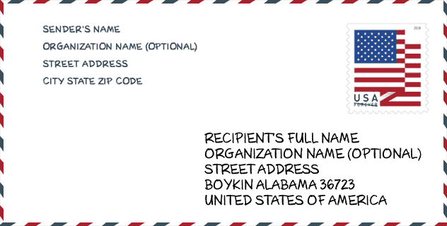
Contoh Sampul Surat

Ini adalah contoh sampul surat zip AS. Anda boleh menggunakan poskod 5 digit atau poskod 9 digit terperinci untuk menyalin surat dalam format alamat berikut.
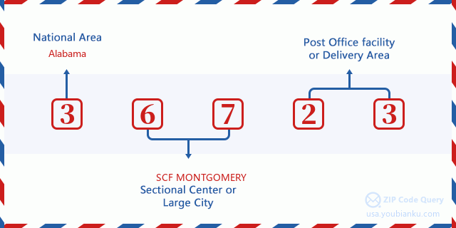
36723 Maksud Asas
Apakah maksud setiap digit Poskod 36723? Angka pertama menunjukkan kawasan negara, yang berjulat dari sifar untuk Timur Laut hingga sembilan untuk Barat jauh. 2-3 digit adalah kod kemudahan pusat keratan di rantau itu. Dua digit terakhir menandakan pejabat pos kecil atau zon pos.
Peta Atas Talian

Ini peta atas talian untuk alamat Boykin, Alabama, United States. Anda boleh menggunakan butang untuk bergerak dan zum masuk/keluar. Maklumat peta ini untuk rujukan sahaja.
Jantina

In all the statistical population, the male population is 113, the female population is 117.
- Male Population: 113
- Female Population: 117
bangsa

In all the statistical population, the male population is 113, the female population is 117.
- White Population: 16
- Black Population: 212
- Hispanic Population: 2
- Asian Population: 0
- Hawaiian Population: 0
- Indian Population: 0
- Other Population: 2
Umur

In all the statistical population, the White population is 16, the Black population is 212, the Hispanic population is 2, the Asian population is 0, the Hawaiian population is 0, the Indian Ppopulation is 0 and Other population is 2.
- Age's Median: 40.5
- Median of male age: 37.8
- Median of female age: 43.9
Households for Poskod 36723
ZIP code 36723 has 86 households, with an average number of 2.67 persons per household. The average income per household in Zip code 36723 is 0 USD, and the average house value is 0 USD.
- Households Per Zipcode: 86
- Orang Setiap Isi Rumah: 2.67
- Nilai Rumah Purata: 0
- Pendapatan Setiap Isi Rumah: 0
Geographic

The latitude of the Zip code 36723 is 32.093615, the longitude is -87.282594, and the elevation is 88. It has land area of 6.667 square miles, and water area of 3.569 square miles. The time zone for ZIP code 36723 is Central (GMT -06:00). Daylight saving time should be observed in the area where the zip code is located.
- Latitud: 32.093615
- Longitud: -87.282594
- Kenaikan: 88
- Kawasan tanah: 6.667
- Water Area: 3.569
- Zon Waktu: Central (GMT -06:00)
- Rantau: South
- Bahagian: East South Central
- Penjimatan Cahaya Siang: Y
Daerah Kongres

The Congressional District for ZIP code 36723 is Alabama's 07th congressional district, the Congressional Land Area is 10156.13 square mile.
- Daerah Kongres: 07th
- Kawasan Tanah Kongres: 10156.13
Delivery

In the ZIP code 36723, there are 0 residential delivery mailboxes and centralized units, and 0 commercial delivery mailbox and centralized units, 0 single family deliveries and 0 multifamily deliveries, and the box count is 49. The main post office does not have city delivery carrier routes for the ZIP code 36723.
- Delivery Residential: 0
- Delivery Business: 0
- Delivery Total: 49
- Unit Penghantaran Keluarga Tunggal: 0
- Multi Family Delivery Units: 0
- Penunjuk Penghantaran Bandar: N
Faedah Jaminan Sosial

Terdapat 45 penerima dengan faedah dalam status pembayaran semasa untuk poskod 36723, yang mana 25 adalah pekerja yang sudah bersara, 10 adalah pekerja yang kurang upaya, 5 adalah janda dan ibu bapa, 0 adalah pasangan dan 5 adalah anak-anak. Bilangan penerima yang berumur 65 tahun atau lebih adalah 25. Jumlah faedah bulanan adalah 43,000 USD, di mana 25,000 USD untuk pekerja yang sudah bersara, 3,000 USD untuk janda dan ibu bapa.
- Jumlah nombor: 45
- Bilangan pekerja yang telah bersara: 25
- Bilangan pekerja kurang upaya: 10
- Bilangan balu dan ibu bapa: 5
- Nombor Pasangan: 0
- Nombor Kanak-kanak: 5
- Semua benefisiari setiap bulan: 43,000
- Pekerja yang telah bersara sebulan: 25,000
- Janda dan ibu bapa setiap bulan: 3,000
- Bilangan penerima yang berumur 65 tahun ke atas: 25


Tambah komen baharu