Poskod: 46047, Hobbs, IN
Poskod 46047 terletak di Hobbs, Indiana. Butirannya Negeri, Kaunti, Bandar, Longitud, Latitud, Contoh Sampul Surat, Penduduk adalah seperti di bawah.

Poskod 46047 Maklumat

-
-
Negara:
U.S. - Amerika Syarikat
Negeri:
FIPS Daerah:
18159
Kaunti:
Bandar:
Kod Kawasan:
Jenis Bandar ?In many cases, a ZIP Code can have multiple "names", meaning cities, towns, or subdivisions, in its boundaries. However, it will ALWAYS have exactly 1 "default" name. D - Default - This is the "preferred" name - by the USPS - for a city. Each ZIP Code has one - and only one - "default" name. In most cases, this is what people who live in that area call the city as well. A - Acceptable - This name can be used for mailing purposes. Often times alternative names are large neighborhoods or sections of the city/town. In some cases a ZIP Code may have several "acceptable" names which is used to group towns under one ZIP Code. N - Not Acceptable - A "not acceptable" name is, in many cases, a nickname that residents give that location. According to the USPS, you should NOT send mail to that ZIP Code using the "not acceptable" name when mailing.:
D (Default)
Poskod:
46047
❓Apa maksud D (Default)? Ini adalah nama "pilihan" - oleh USPS - untuk sebuah bandar. Setiap Poskod mempunyai satu - dan hanya satu - "lalai" nama. Dalam kebanyakan kes, inilah yang dinamakan orang yang tinggal di kawasan itu juga sebagai bandar.
Poskod 46047 Plus 4
Poskod 5 tambah 4 ialah lanjutan kod pos 5 digit, Ia boleh digunakan untuk mencari lokasi yang lebih terperinci. Empat digit terakhir menandakan segmen atau satu sisi jalan atau apartmen. Anda boleh mencari kod ZIP+4 dan alamat poskod 46047 yang sepadan di bawah.
| Poskod 5 Plus 4 | Alamat |
|---|---|
| 46047-0301 | PO BOX 301, HOBBS, IN |
| 46047-0451 | PO BOX 451, HOBBS, IN |
| 46047-9997 | 3484 E 150, HOBBS, IN |
| 46047-9999 | 0 GENERAL DELIVERY, HOBBS, IN |
| 46047-0302 | PO BOX 302, HOBBS, IN |
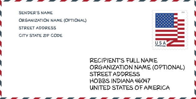
Contoh Sampul Surat

Ini adalah contoh sampul surat zip AS. Anda boleh menggunakan poskod 5 digit atau poskod 9 digit terperinci untuk menyalin surat dalam format alamat berikut.
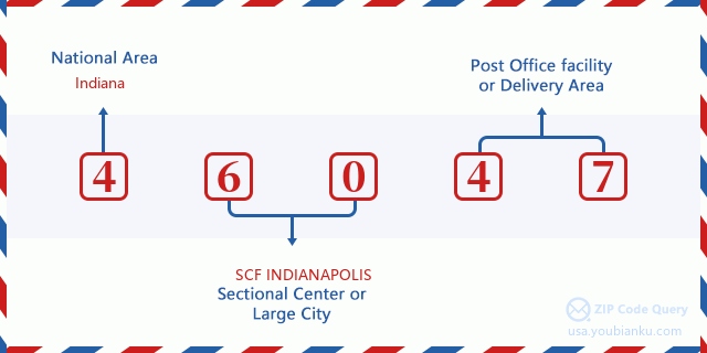
46047 Maksud Asas
Apakah maksud setiap digit Poskod 46047? Angka pertama menunjukkan kawasan negara, yang berjulat dari sifar untuk Timur Laut hingga sembilan untuk Barat jauh. 2-3 digit adalah kod kemudahan pusat keratan di rantau itu. Dua digit terakhir menandakan pejabat pos kecil atau zon pos.
Peta Atas Talian

Ini peta atas talian untuk alamat Hobbs, Indiana, United States. Anda boleh menggunakan butang untuk bergerak dan zum masuk/keluar. Maklumat peta ini untuk rujukan sahaja.
Jantina

In all the statistical population, the male population is 20, the female population is 23.
- Male Population: 20
- Female Population: 23
bangsa

In all the statistical population, the male population is 20, the female population is 23.
- White Population: 43
- Black Population: 0
- Hispanic Population: 3
- Asian Population: 0
- Hawaiian Population: 0
- Indian Population: 0
- Other Population: 0
Umur

In all the statistical population, the White population is 43, the Black population is 0, the Hispanic population is 3, the Asian population is 0, the Hawaiian population is 0, the Indian Ppopulation is 0 and Other population is 0.
- Age's Median: 28.5
- Median of male age: 32.5
- Median of female age: 24.5
Households for Poskod 46047
ZIP code 46047 has 15 households, with an average number of 2.87 persons per household. The average income per household in Zip code 46047 is 0 USD, and the average house value is 0 USD.
- Households Per Zipcode: 15
- Orang Setiap Isi Rumah: 2.87
- Nilai Rumah Purata: 0
- Pendapatan Setiap Isi Rumah: 0
Geographic

The latitude of the Zip code 46047 is 40.283718, the longitude is -85.944235, and the elevation is 867. It has land area of 0.013 square miles, and water area of 0 square miles. The time zone for ZIP code 46047 is Eastern (GMT -05:00). Daylight saving time should be observed in the area where the zip code is located.
- Latitud: 40.283718
- Longitud: -85.944235
- Kenaikan: 867
- Kawasan tanah: 0.013
- Water Area: 0
- Zon Waktu: Eastern (GMT -05:00)
- Rantau: Midwest
- Bahagian: East North Central
- Penjimatan Cahaya Siang: Y
Daerah Kongres

The Congressional District for ZIP code 46047 is Indiana's 05th congressional district, the Congressional Land Area is 1924.76 square mile.
- Daerah Kongres: 05th
- Kawasan Tanah Kongres: 1924.76
Delivery

In the ZIP code 46047, there are 0 residential delivery mailboxes and centralized units, and 0 commercial delivery mailbox and centralized units, 0 single family deliveries and 0 multifamily deliveries, and the box count is 8. The main post office does not have city delivery carrier routes for the ZIP code 46047.
- Delivery Residential: 0
- Delivery Business: 0
- Delivery Total: 8
- Unit Penghantaran Keluarga Tunggal: 0
- Multi Family Delivery Units: 0
- Penunjuk Penghantaran Bandar: N


Tambah komen baharu