Amerika Syarikat Poskod: 46060
Ini senarai halaman Indiana Poskod 46060. Butiran Negeri, Kaunti, Bandar, Longitud, Latitud, Contoh Sampul Surat, Populasi seperti di bawah.
 highlighting postal theme and local features, such as scenes from Strawtown Koteewi Park including boating on White River and zipline, as well as archaeological elements. Depicts vintage stamps, 'Strawtown, IN 46060' postmark on mailboxes, and classic mail van, illustrating the historical importance of postal service.")
Poskod 46060 Maklumat

-
-
Negara:
U.S. - Amerika Syarikat
Negeri:
Negeri FIPS:
18
Poskod:
46060
Poskod Jenis:
S (Standard)
❓Apa maksud S (Standard)? Poskod "standard" adalah apa yang difikirkan oleh kebanyakan orang ketika mereka bercakap mengenai Poskod - pada dasarnya sebuah bandar, bandar, atau pembahagian bandar yang mempunyai perkhidmatan mel.
Poskod 46060 - Bandar

Ini ialah maklumat bandar yang sepadan dengan 46060:
| Negeri | Kaunti | Bandar | Jenis Bandar ?In many cases, a ZIP Code can have multiple "names", meaning cities, towns, or subdivisions, in its boundaries. However, it will ALWAYS have exactly 1 "default" name. D - Default - This is the "preferred" name - by the USPS - for a city. Each ZIP Code has one - and only one - "default" name. In most cases, this is what people who live in that area call the city as well. A - Acceptable - This name can be used for mailing purposes. Often times alternative names are large neighborhoods or sections of the city/town. In some cases a ZIP Code may have several "acceptable" names which is used to group towns under one ZIP Code. N - Not Acceptable - A "not acceptable" name is, in many cases, a nickname that residents give that location. According to the USPS, you should NOT send mail to that ZIP Code using the "not acceptable" name when mailing. | Poskod |
|---|---|---|---|---|
| IN | Hamilton | Noblesville | D (Default) | 46060 |
| IN | Hamilton | Strawtown | N (Not Acceptable) | 46060 |
❓Apa maksud D (Default)? Ini adalah nama "pilihan" - oleh USPS - untuk sebuah bandar. Setiap Poskod mempunyai satu - dan hanya satu - "lalai" nama. Dalam kebanyakan kes, inilah yang dinamakan orang yang tinggal di kawasan itu juga sebagai bandar.
❓Apa maksud N (Not Acceptable)? Nama "tidak boleh diterima" adalah, dalam banyak keadaan, nama panggilan yang diberikan oleh penduduk di lokasi tersebut. Menurut USPS, anda TIDAK boleh menghantar surat ke Poskod tersebut dengan menggunakan nama "tidak boleh diterima" semasa mel.
Poskod 46060 Plus 4
Poskod 5 tambah 4 ialah lanjutan kod pos 5 digit, Ia boleh digunakan untuk mencari lokasi yang lebih terperinci. Empat digit terakhir menandakan segmen atau satu sisi jalan atau apartmen. Anda boleh mencari kod ZIP+4 dan alamat poskod 46060 yang sepadan di bawah.
| Poskod 5 Plus 4 | Alamat |
|---|---|
| 46060-0001 | 9600 ANGELICA DR, NOBLESVILLE, IN |
| 46060-0002 | 15320 ENDEAVOR DR #00000900 , NOBLESVILLE, IN |
| 46060-0003 | 14350 MUNDY DR #00000500 , NOBLESVILLE, IN |
| 46060-06ND | 16200 STONY RIDGE DR, NOBLESVILLE, IN |
| 46060-1000 | 1000 EDITH AVE, NOBLESVILLE, IN |
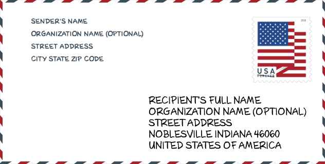
Contoh Sampul Surat

Ini adalah contoh sampul surat zip AS. Anda boleh menggunakan poskod 5 digit atau poskod 9 digit terperinci untuk menyalin surat dalam format alamat berikut.
46060 Maksud Asas
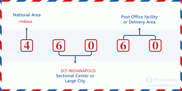
Apakah maksud setiap digit Poskod 46060? Angka pertama menunjukkan kawasan negara, yang berjulat dari sifar untuk Timur Laut hingga sembilan untuk Barat jauh. 2-3 digit adalah kod kemudahan pusat keratan di rantau itu. Dua digit terakhir menandakan pejabat pos kecil atau zon pos.
Peta Atas Talian

Ini peta atas talian untuk alamat Strawtown, Indiana, United States. Anda boleh menggunakan butang untuk bergerak dan zum masuk/keluar. Maklumat peta ini untuk rujukan sahaja.
Hospital

Ini senarai halaman Poskod 46060 - Hospital. Butiran Nama Hospital, Jalan, Bandar, Negeri, Poskod, Telefon adalah seperti di bawah.
- Nama: RIVERVIEW HEALTH
- Alamat: NOBLESVILLE
- Bandar: 395 WESTFIELD RD
- Negeri: IN
- Poskod: 46060
- Telefon: (317) 773-0760
Perpustakaan

Ini senarai halaman Poskod 46060 - Perpustakaan. Butiran Perpustakaan Nama, Alamat, Bandar, Negeri, Poskod, Telefon seperti di bawah.
- Nama: HAMILTON EAST PUBLIC LIBRARY
- Alamat: ONE LIBRARY PLAZA
- Bandar: NOBLESVILLE
- Negeri: IN - Indiana
- Poskod: 46060
- Telefon: (317) 773-1384
Sekolah

Ini senarai halaman Poskod 46060 - Sekolah. Butiran Sekolah Nama, Alamat, Bandar, Negeri, Poskod seperti di bawah.
| Sekolah Nama | Alamat | Bandar | Negeri | Tingkatan | Poskod |
|---|---|---|---|---|---|
| Pendleton Juvenile Correctional | 9310 S SR 67 | Pendleton | IN | UG | 46060 |
| Options Noblesville | 9945 CUMBERLAND POINTE BLVD | NOBLESVILLE | IN | UG | 46060 |
| Excel Center - Noblesville | 300 N 17 St | Noblesville | IN | UG | 46060 |
| White River Elementary School | 19000 Cumberland Rd | Noblesville | IN | UG | 46060 |
| Noblesville High School | 18111 Cumberland Rd | Noblesville | IN | UG | 46060 |
| Noblesville East Middle School | 1625 Field Dr | Noblesville | IN | UG | 46060 |
| North Elementary School | 440 N 10th St | Noblesville | IN | UG | 46060 |
| Stony Creek Elementary School | 1350 Greenfield Pike | Noblesville | IN | UG | 46060 |
| Promise Road Elementary | 14975 Promise Rd | Noblesville | IN | UG | 46060 |
| Juvenile Services Center | 18006 Cumberland Road | Noblesville | IN | UG | 46060 |
| Durbin Elementary School | 18000 Durbin Rd | Noblesville | IN | UG | 46060 |
Population for Poskod 46060

What is the total population in ZIP Code 46060? Below is detail information.
- Population for Poskod 46060: 47,160
- 2010 Populasi: 34,708
The 2020 demographic statistics are in progress. The current population in ZIP code 46060 is 47,160, and the population in 2010 is 34,708.
Jantina

In all the statistical population, the male population is 16,873, the female population is 17,835.
- Male Population: 16,873
- Female Population: 17,835
bangsa

In all the statistical population, the male population is 16,873, the female population is 17,835.
- White Population: 31,913
- Black Population: 1,813
- Hispanic Population: 1,670
- Asian Population: 697
- Hawaiian Population: 56
- Indian Population: 190
- Other Population: 729
Umur

In all the statistical population, the White population is 31,913, the Black population is 1,813, the Hispanic population is 1,670, the Asian population is 697, the Hawaiian population is 56, the Indian Ppopulation is 190 and Other population is 729.
- Age's Median: 32.9
- Median of male age: 32.3
- Median of female age: 33.5
Households for Poskod 46060
ZIP code 46060 has 12,778 households, with an average number of 2.67 persons per household. The average income per household in Zip code 46060 is 73,936 USD, and the average house value is 186,400 USD.
- Households Per Zipcode: 12,778
- Orang Setiap Isi Rumah: 2.67
- Nilai Rumah Purata: 186,400
- Pendapatan Setiap Isi Rumah: 73,936
Housing Unit

In ZIP code 46060, the growth rank of housing unit is 64, the number of housing unit was 274,569 in 2010 and increased to 282,810 in 2011, the growth increase number is 8,241, the growth increase percentage is 3.0%.
- Growth Rank: 64
- Housing Units Estimate in 2010: 274,569
- Housing Units Estimate in 2011: 282,810
- Growth Increase Number: 8,241
- Growth Increase Percentage: 3.0%
Geographic

The latitude of the Zip code 46060 is 40.071194, the longitude is -85.948569, and the elevation is 809. It has land area of 79.883 square miles, and water area of 0.74 square miles. The time zone for ZIP code 46060 is Eastern (GMT -05:00). Daylight saving time should be observed in the area where the zip code is located.
- Latitud: 40.071194
- Longitud: -85.948569
- Kenaikan: 809
- Kawasan tanah: 79.883
- Water Area: 0.74
- Zon Waktu: Eastern (GMT -05:00)
- Rantau: Midwest
- Bahagian: East North Central
- Penjimatan Cahaya Siang: Y
Daerah Kongres

The Congressional District for ZIP code 46060 is Indiana's 05th congressional district, the Congressional Land Area is 1924.76 square mile.
- Daerah Kongres: 05th
- Kawasan Tanah Kongres: 1924.76
Delivery

In the ZIP code 46060, there are 17,663 residential delivery mailboxes and centralized units, and 1,372 commercial delivery mailbox and centralized units, 13,292 single family deliveries and 2,135 multifamily deliveries, and the box count is 18,614. The main post office has city delivery carrier routes for the ZIP code 46060.
- Delivery Residential: 17,663
- Delivery Business: 1,372
- Delivery Total: 18,614
- Unit Penghantaran Keluarga Tunggal: 13,292
- Multi Family Delivery Units: 2,135
- Penunjuk Penghantaran Bandar: Y
Perniagaan

In ZIP code 46060, the number of business is 1,331, the number of employee is 19,909, the business first quarter payroll is 187,085,000 USD, the business annual payroll is 785,866,000 USD.
- Number Of Businesses: 1,331
- Number Of Employees: 19,909
- Gaji Suku Pertama Perniagaan: 187,085,000
- Gaji Tahunan Perniagaan: 785,866,000
Faedah Jaminan Sosial

Terdapat 6,390 penerima dengan faedah dalam status pembayaran semasa untuk poskod 46060, yang mana 4,455 adalah pekerja yang sudah bersara, 820 adalah pekerja yang kurang upaya, 415 adalah janda dan ibu bapa, 205 adalah pasangan dan 495 adalah anak-anak. Bilangan penerima yang berumur 65 tahun atau lebih adalah 4,780. Jumlah faedah bulanan adalah 9,541,000 USD, di mana 7,267,000 USD untuk pekerja yang sudah bersara, 639,000 USD untuk janda dan ibu bapa.
- Jumlah nombor: 6,390
- Bilangan pekerja yang telah bersara: 4,455
- Bilangan pekerja kurang upaya: 820
- Bilangan balu dan ibu bapa: 415
- Nombor Pasangan: 205
- Nombor Kanak-kanak: 495
- Semua benefisiari setiap bulan: 9,541,000
- Pekerja yang telah bersara sebulan: 7,267,000
- Janda dan ibu bapa setiap bulan: 639,000
- Bilangan penerima yang berumur 65 tahun ke atas: 4,780


Tambah komen baharu