Amerika Syarikat Poskod: 47199
Ini senarai halaman Indiana Poskod 47199. Butiran Negeri, Kaunti, Bandar/Agency, Longitud, Latitud, Contoh Sampul Surat, Populasi seperti di bawah.

Poskod 47199 Maklumat

-
-
Negara:
U.S. - Amerika Syarikat
Negeri:
Negeri FIPS:
18
Poskod:
47199
Poskod Jenis:
U (Unique)
❓Apa maksud U (Unique)? Syarikat, organisasi, dan institusi yang menerima sejumlah besar surat diberi jenis Poskod "unik".
Poskod 47199 - Bandar/Agency

Ini ialah maklumat bandar yang sepadan dengan 47199:
| Negeri | Kaunti | Bandar/Agency | Jenis Bandar ?In many cases, a ZIP Code can have multiple "names", meaning cities, towns, or subdivisions, in its boundaries. However, it will ALWAYS have exactly 1 "default" name. D - Default - This is the "preferred" name - by the USPS - for a city. Each ZIP Code has one - and only one - "default" name. In most cases, this is what people who live in that area call the city as well. A - Acceptable - This name can be used for mailing purposes. Often times alternative names are large neighborhoods or sections of the city/town. In some cases a ZIP Code may have several "acceptable" names which is used to group towns under one ZIP Code. N - Not Acceptable - A "not acceptable" name is, in many cases, a nickname that residents give that location. According to the USPS, you should NOT send mail to that ZIP Code using the "not acceptable" name when mailing. | Poskod |
|---|---|---|---|---|
| IN | Clark | Bureau Of Census Decennial | N (Not Acceptable) | 47199 |
| IN | Clark | Jeffersonville | D (Default) | 47199 |
| IN | Clark | Jeffersonvlle | A (Acceptable) | 47199 |
❓Apa maksud D (Default)? Ini adalah nama "pilihan" - oleh USPS - untuk sebuah bandar. Setiap Poskod mempunyai satu - dan hanya satu - "lalai" nama. Dalam kebanyakan kes, inilah yang dinamakan orang yang tinggal di kawasan itu juga sebagai bandar.
❓Apa maksud A (Acceptable)? Nama ini boleh digunakan untuk tujuan mel. Seringkali nama alternatif adalah kawasan kejiranan atau bahagian bandar / bandar yang besar. Dalam beberapa kes, Poskod mungkin mempunyai beberapa nama "boleh diterima" yang digunakan untuk mengelompokkan bandar di bawah satu Poskod.
❓Apa maksud N (Not Acceptable)? Nama "tidak boleh diterima" adalah, dalam banyak keadaan, nama panggilan yang diberikan oleh penduduk di lokasi tersebut. Menurut USPS, anda TIDAK boleh menghantar surat ke Poskod tersebut dengan menggunakan nama "tidak boleh diterima" semasa mel.
Poskod 47199 Plus 4
Poskod 5 tambah 4 ialah lanjutan kod pos 5 digit, Ia boleh digunakan untuk mencari lokasi yang lebih terperinci. Empat digit terakhir menandakan segmen atau satu sisi jalan atau apartmen. Anda boleh mencari kod ZIP+4 dan alamat poskod 47199 yang sepadan di bawah.
| Poskod 5 Plus 4 | Alamat |
|---|---|
| 47199-5501 | PO BOX 5500, JEFFERSONVILLE, IN |
| 47199-5508 | PO BOX 5508, JEFFERSONVILLE, IN |
| 47199-0001 | PO BOX 5000, JEFFERSONVILLE, IN |
| 47199-0002 | PO BOX 5010, JEFFERSONVILLE, IN |
| 47199-0003 | PO BOX 5020, JEFFERSONVILLE, IN |
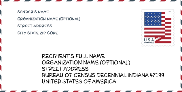
Contoh Sampul Surat

Ini adalah contoh sampul surat zip AS. Anda boleh menggunakan poskod 5 digit atau poskod 9 digit terperinci untuk menyalin surat dalam format alamat berikut.
47199 Maksud Asas
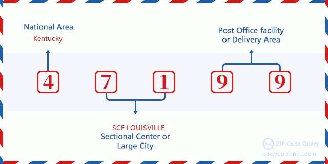
Apakah maksud setiap digit Poskod 47199? Angka pertama menunjukkan kawasan negara, yang berjulat dari sifar untuk Timur Laut hingga sembilan untuk Barat jauh. 2-3 digit adalah kod kemudahan pusat keratan di rantau itu. Dua digit terakhir menandakan pejabat pos kecil atau zon pos.
Peta Atas Talian

Ini peta atas talian untuk alamat Jeffersonvlle, Indiana, United States. Anda boleh menggunakan butang untuk bergerak dan zum masuk/keluar. Maklumat peta ini untuk rujukan sahaja.
Geographic

The latitude of the Zip code 47199 is 38.290100, the longitude is -85.751400, and the elevation is 454. It has land area of 0 square miles, and water area of 0 square miles. The time zone for ZIP code 47199 is Eastern (GMT -05:00). Daylight saving time should be observed in the area where the zip code is located.
- Latitud: 38.290100
- Longitud: -85.751400
- Kenaikan: 454
- Kawasan tanah: 0
- Water Area: 0
- Zon Waktu: Eastern (GMT -05:00)
- Rantau: Midwest
- Bahagian: East North Central
- Penjimatan Cahaya Siang: Y
Daerah Kongres

The Congressional District for ZIP code 47199 is Indiana's 09th congressional district, the Congressional Land Area is 4486.77 square mile.
- Daerah Kongres: 09th
- Kawasan Tanah Kongres: 4486.77
Delivery

In the ZIP code 47199, there are 0 residential delivery mailboxes and centralized units, and 0 commercial delivery mailbox and centralized units, 0 single family deliveries and 0 multifamily deliveries, and the box count is 6. The main post office does not have city delivery carrier routes for the ZIP code 47199.
- Delivery Residential: 0
- Delivery Business: 0
- Delivery Total: 6
- Unit Penghantaran Keluarga Tunggal: 0
- Multi Family Delivery Units: 0
- Penunjuk Penghantaran Bandar: N


Tambah komen baharu