Verenigde Staten Postcode: 00802
Dit is de paginalijst van Virgin Islands Postcode 00802. Hieronder is het detail van Staat, Graafschap, Stad, Lengte, Breedtegraad, Envelop Voorbeeld, Bevolking.
Postcode 00802 Informatie

-
-
Land:
U.S. - Verenigde Staten
Staat:
Staat FIPS:
78
Netnummer:
Postcode:
00802
Postcode Type:
S (Standard)
❓Wat betekent S (Standard)? Een "standaard" postcode is waar de meeste mensen aan denken als ze het over postcodes hebben - in wezen een stad, een stad of een afdeling van een stad die een postdienst heeft.
Postcode 00802 - Stad

Dit is de stadsinformatie die overeenkomt met 00802:
| Staat | Graafschap | Stad | Stadtype ?In many cases, a ZIP Code can have multiple "names", meaning cities, towns, or subdivisions, in its boundaries. However, it will ALWAYS have exactly 1 "default" name. D - Default - This is the "preferred" name - by the USPS - for a city. Each ZIP Code has one - and only one - "default" name. In most cases, this is what people who live in that area call the city as well. A - Acceptable - This name can be used for mailing purposes. Often times alternative names are large neighborhoods or sections of the city/town. In some cases a ZIP Code may have several "acceptable" names which is used to group towns under one ZIP Code. N - Not Acceptable - A "not acceptable" name is, in many cases, a nickname that residents give that location. According to the USPS, you should NOT send mail to that ZIP Code using the "not acceptable" name when mailing. | Postcode |
|---|---|---|---|---|
| VI | Saint Thomas | Charlotte Ama | A (Acceptable) | 00802 |
| VI | Saint Thomas | Charlotte Amalie | A (Acceptable) | 00802 |
| VI | Saint Thomas | St Thomas | D (Default) | 00802 |
❓Wat betekent D (Default)? Dit is de "geprefereerde" naam - door de USPS - voor een stad. Elke postcode heeft één - en slechts één - "standaard" naam. In de meeste gevallen noemen mensen die in dat gebied wonen de stad ook.
❓Wat betekent A (Acceptable)? Deze naam kan worden gebruikt voor mailingdoeleinden. Vaak zijn alternatieve namen grote buurten of delen van de stad / stad. In sommige gevallen kan een postcode meerdere "acceptabele" namen hebben die worden gebruikt om steden onder één postcode te groeperen.
Postcode 00802 Plus 4
ZIP Code 5 plus 4 is de uitbreiding van de 5-cijferige postcode, het kan worden gebruikt om een meer gedetailleerde locatie te vinden. De laatste vier cijfers duiden een segment of een kant van een straat of een appartement aan. Hieronder vindt u de postcode en het bijbehorende adres van de postcode 00802.
| Postcode 5 Plus 4 | Adres |
|---|---|
| 00802-1000 | 6915 VESSUP LN, ST THOMAS, VI |
| 00802-1001 | 6900 VESSUP LN, ST THOMAS, VI |
| 00802-1001 | 6932 VESSUP LN, ST THOMAS, VI |
| 00802-1002 | 6801 ESTATE NAZARETH, ST THOMAS, VI |
| 00802-1003 | 6700 ESTATE NAZARETH, ST THOMAS, VI |
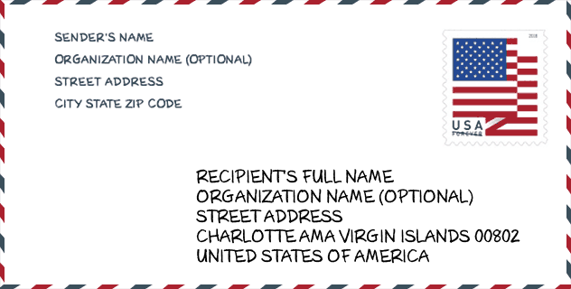
Envelop Voorbeeld

Dit is een voorbeeld van een Amerikaanse postenvelop. U kunt een 5-cijferige postcode of een gedetailleerde 9-cijferige postcode gebruiken om de mail in het volgende adresformaat te kopiëren.
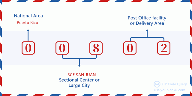
00802 Basisbetekenis
Waar staat elk cijfer van postcode 00802 voor? Het eerste cijfer geeft een nationaal gebied aan, dat varieert van nul voor het noordoosten tot negen voor het verre westen. De 2-3 cijfers zijn de code van een sectiecentrumfaciliteit in die regio. De laatste twee cijfers duiden kleine postkantoren of postzones aan.
Online landkaart

Het is een online kaart van adres St Thomas, Virgin Islands, United States. U kunt Knopje gebruiken te in/uitzoomen. De kaartinformatie is alleen ter referentie.
School

Dit is de paginalijst van Postcode 00802 - School. Hieronder is het detail van School Naam, Adres, Stad, Staat, Postcode.
| School Naam | Adres | Stad | Staat | Klassen | Postcode |
|---|---|---|---|---|---|
| CHARLOTTE AMALIE HIGH SCHOOL | 8 and 9 ESTATE THOMAS | Saint Thomas | VI | 09-12 | 00802 |
| IVANNA EUDORA KEAN HIGH SCHOOL | 1 and 2 ESTate NAZARETH | Saint Thomas | VI | 09-12 | 00802 |
| JANE E. TUITT ELEMENTARY SCHOOL | 19 LEVOKI STRAEDE | Saint Thomas | VI | KG-04 | 00802 |
| JOSEPH GOMEZ ELEMENTARY SCHOOL | 142 ANNAS RETREAT | Saint Thomas | VI | KG-05 | 00802 |
| JOSEPH SIBILLY ELEMENTARY SCHOOL | 14 15 16 ESTATE ELIZABETH | Saint Thomas | VI | PK-06 | 00802 |
| LOCKHART ELEMENTARY SCHOOL | 41 ESTATE THOMAS | Saint Thomas | VI | KG-03 | 00802 |
| ULLA F MULLER ELEMENTARY SCHOOL | 7B ESTATE CONTANT | Saint Thomas | VI | KG-06 | 00802 |
| YVONNE BOWSKY ELEMENTARY SCHOOL | 15B and 16 ESTATE MANDAHL | Saint Thomas | VI | PK-05 | 00802 |
| BERTHA BOSCHULTE JUNIOR HIGH | 9 1 and 12A BOVONI | Saint Thomas | VI | 06-08 | 00802 |
Geographic

The latitude of the Zip code 00802 is 18.343600, the longitude is -64.932200, and the elevation is 35. It has land area of 27.675 square miles, and water area of 3.447 square miles. The time zone for ZIP code 00802 is Atlantic (GMT -04:00). Daylight saving time should be observed in the area where the zip code is located.
- Breedtegraad: 18.343600
- Lengte: -64.932200
- Elevatie: 35
- Landoppervlak: 27.675
- Water Area: 3.447
- Tijd Zone: Atlantic (GMT -04:00)
- Zomertijd: N
Levering

In the ZIP code 00802, there are 6,971 residential delivery mailboxes and centralized units, and 1,552 commercial delivery mailbox and centralized units, 2,326 single family deliveries and 1,772 multifamily deliveries, and the box count is 8,455. The main post office has city delivery carrier routes for the ZIP code 00802.
- Delivery Residential: 6,971
- Delivery Business: 1,552
- Delivery Total: 8,455
- Leveringseenheden voor één gezin: 2,326
- Multi Family Delivery Units: 1,772
- Stadsleveringsindicator: Y


Reactie toevoegen