Postcode: 02061, Norwell, MA
Postcode 02061 bevindt zich in Norwell, Massachusetts. Het detail staat, provincie, stad, lengtegraad, breedtegraad, envelop Voorbeeld, Bevolking is zoals hieronder.

Postcode 02061 Informatie

-
-
Land:
U.S. - Verenigde Staten
Staat:
Regio FIPS:
25023
Graafschap:
Stad:
Stadtype ?In many cases, a ZIP Code can have multiple "names", meaning cities, towns, or subdivisions, in its boundaries. However, it will ALWAYS have exactly 1 "default" name. D - Default - This is the "preferred" name - by the USPS - for a city. Each ZIP Code has one - and only one - "default" name. In most cases, this is what people who live in that area call the city as well. A - Acceptable - This name can be used for mailing purposes. Often times alternative names are large neighborhoods or sections of the city/town. In some cases a ZIP Code may have several "acceptable" names which is used to group towns under one ZIP Code. N - Not Acceptable - A "not acceptable" name is, in many cases, a nickname that residents give that location. According to the USPS, you should NOT send mail to that ZIP Code using the "not acceptable" name when mailing.:
D (Default)
Postcode:
02061
❓Wat betekent D (Default)? Dit is de "geprefereerde" naam - door de USPS - voor een stad. Elke postcode heeft één - en slechts één - "standaard" naam. In de meeste gevallen noemen mensen die in dat gebied wonen de stad ook.
Postcode 02061 Plus 4
ZIP Code 5 plus 4 is de uitbreiding van de 5-cijferige postcode, het kan worden gebruikt om een meer gedetailleerde locatie te vinden. De laatste vier cijfers duiden een segment of een kant van een straat of een appartement aan. Hieronder vindt u de postcode en het bijbehorende adres van de postcode 02061.
| Postcode 5 Plus 4 | Adres |
|---|---|
| 02061-0001 | PO BOX 1, NORWELL, MA |
| 02061-0121 | PO BOX 121, NORWELL, MA |
| 02061-0201 | PO BOX 201, NORWELL, MA |
| 02061-0281 | PO BOX 281, NORWELL, MA |
| 02061-0361 | PO BOX 361, NORWELL, MA |
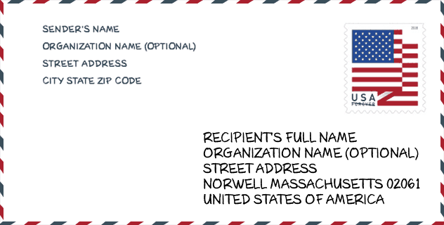
Envelop Voorbeeld

Dit is een voorbeeld van een Amerikaanse postenvelop. U kunt een 5-cijferige postcode of een gedetailleerde 9-cijferige postcode gebruiken om de mail in het volgende adresformaat te kopiëren.
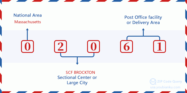
02061 Basisbetekenis
Waar staat elk cijfer van postcode 02061 voor? Het eerste cijfer geeft een nationaal gebied aan, dat varieert van nul voor het noordoosten tot negen voor het verre westen. De 2-3 cijfers zijn de code van een sectiecentrumfaciliteit in die regio. De laatste twee cijfers duiden kleine postkantoren of postzones aan.
Online landkaart

Het is een online kaart van adres Norwell, Massachusetts, United States. U kunt Knopje gebruiken te in/uitzoomen. De kaartinformatie is alleen ter referentie.
Museum

Dit is de paginalijst van Postcode 02061 - Museum. Hieronder is het detail van Museum Naam, Straat, Stad, Staat, Postcode, Telefoon.
| Naam | Straat | Stad | Staat | Postcode | Telefoon |
| SOUTH SHORE NATURAL SCIENCE CENTER | 48 JACOBS LN | NORWELL | MA | 02061 | (781) 659-2559 |
| NORWELL HISTORICAL SOCIETY | PO BOX 693 | NORWELL | MA | 02061 | (781) 659-1888 |
Bibliotheek

Dit is de paginalijst van Postcode 02061 - Bibliotheek. Hieronder is het detail van Bibliotheek Naam, Adres, Stad, Staat, Postcode, Telefoon.
- Naam: NORWELL PUBLIC LIBRARY
- Adres: 64 SOUTH ST.
- Stad: NORWELL
- Staat: MA - Massachusetts
- Postcode: 02061
- Telefoon: (781) 659-2015
School

Dit is de paginalijst van Postcode 02061 - School. Hieronder is het detail van School Naam, Adres, Stad, Staat, Postcode.
| School Naam | Adres | Stad | Staat | Klassen | Postcode |
|---|---|---|---|---|---|
| South Shore Charter Public School | 100 Longwater Circle | Norwell | MA | UG | 02061 |
| Grace Farrar Cole | 81 High Street | Norwell | MA | UG | 02061 |
| Norwell High | 18 South Street | Norwell | MA | UG | 02061 |
| Norwell Middle School | 328 Main Street | Norwell | MA | UG | 02061 |
| William G Vinal | 102 Old Oaken Bucket Road | Norwell | MA | UG | 02061 |
Population for Postcode 02061

What is the total population in ZIP Code 02061? Below is detail information.
- Population for Postcode 02061: 10,782
- 2010 Bevolking: 10,506
The 2020 demographic statistics are in progress. The current population in ZIP code 02061 is 10,782, and the population in 2010 is 10,506.
Geslacht

In all the statistical population, the male population is 5,035, the female population is 5,471.
- Male Population: 5,035
- Female Population: 5,471
Race

In all the statistical population, the male population is 5,035, the female population is 5,471.
- White Population: 10,217
- Black Population: 92
- Hispanic Population: 128
- Asian Population: 241
- Hawaiian Population: 0
- Indian Population: 38
- Other Population: 40
Leeftijd

In all the statistical population, the White population is 10,217, the Black population is 92, the Hispanic population is 128, the Asian population is 241, the Hawaiian population is 0, the Indian Ppopulation is 38 and Other population is 40.
- Age's Median: 43.8
- Median of male age: 43.0
- Median of female age: 44.6
Households for Postcode 02061
ZIP code 02061 has 3,553 households, with an average number of 2.89 persons per household. The average income per household in Zip code 02061 is 151,306 USD, and the average house value is 615,700 USD.
- Households Per Zipcode: 3,553
- Personen per huishouden: 2.89
- Gemiddelde huiswaarde: 615,700
- Inkomen per huishouden: 151,306
Geographic

The latitude of the Zip code 02061 is 42.151425, the longitude is -70.821397, and the elevation is 93. It has land area of 20.945 square miles, and water area of 0.308 square miles. The time zone for ZIP code 02061 is Eastern (GMT -05:00). Daylight saving time should be observed in the area where the zip code is located.
- Breedtegraad: 42.151425
- Lengte: -70.821397
- Elevatie: 93
- Landoppervlak: 20.945
- Water Area: 0.308
- Tijd Zone: Eastern (GMT -05:00)
- Regio: Northeast
- Divisie: New England
- Zomertijd: Y
congresdistrict

The Congressional District for ZIP code 02061 is Massachusetts's 08th|09th congressional district, the Congressional Land Area is 326.37|1214.74 square mile.
- congresdistrict: 08th|09th
- Congresgebied: 326.37|1214.74
Levering

In the ZIP code 02061, there are 3,731 residential delivery mailboxes and centralized units, and 592 commercial delivery mailbox and centralized units, 3,431 single family deliveries and 142 multifamily deliveries, and the box count is 4,822. The main post office does not have city delivery carrier routes for the ZIP code 02061.
- Delivery Residential: 3,731
- Delivery Business: 592
- Delivery Total: 4,822
- Leveringseenheden voor één gezin: 3,431
- Multi Family Delivery Units: 142
- Stadsleveringsindicator: N
Bedrijf

In ZIP code 02061, the number of business is 622, the number of employee is 10,466, the business first quarter payroll is 158,025,000 USD, the business annual payroll is 644,297,000 USD.
- Number Of Businesses: 622
- Number Of Employees: 10,466
- Zakelijke salarisadministratie eerste kwartaal: 158,025,000
- Zakelijke jaarlijkse loonlijst: 644,297,000


Reactie toevoegen