Verenigde Staten Postcode: 03241
Dit is de paginalijst van New Hampshire Postcode 03241. Hieronder is het detail van Staat, Graafschap, Stad, Lengte, Breedtegraad, Envelop Voorbeeld, Bevolking.

Postcode 03241 Informatie

-
-
Land:
U.S. - Verenigde Staten
Staat:
Staat FIPS:
33
Netnummer:
Postcode:
03241
Postcode Type:
S (Standard)
❓Wat betekent S (Standard)? Een "standaard" postcode is waar de meeste mensen aan denken als ze het over postcodes hebben - in wezen een stad, een stad of een afdeling van een stad die een postdienst heeft.
Postcode 03241 - Stad

Dit is de stadsinformatie die overeenkomt met 03241:
| Staat | Graafschap | Stad | Stadtype ?In many cases, a ZIP Code can have multiple "names", meaning cities, towns, or subdivisions, in its boundaries. However, it will ALWAYS have exactly 1 "default" name. D - Default - This is the "preferred" name - by the USPS - for a city. Each ZIP Code has one - and only one - "default" name. In most cases, this is what people who live in that area call the city as well. A - Acceptable - This name can be used for mailing purposes. Often times alternative names are large neighborhoods or sections of the city/town. In some cases a ZIP Code may have several "acceptable" names which is used to group towns under one ZIP Code. N - Not Acceptable - A "not acceptable" name is, in many cases, a nickname that residents give that location. According to the USPS, you should NOT send mail to that ZIP Code using the "not acceptable" name when mailing. | Postcode |
|---|---|---|---|---|
| NH | Grafton | E Hebron | N (Not Acceptable) | 03241 |
| NH | Grafton | East Hebron | A (Acceptable) | 03241 |
| NH | Grafton | Groton | N (Not Acceptable) | 03241 |
| NH | Grafton | Hebron | D (Default) | 03241 |
❓Wat betekent D (Default)? Dit is de "geprefereerde" naam - door de USPS - voor een stad. Elke postcode heeft één - en slechts één - "standaard" naam. In de meeste gevallen noemen mensen die in dat gebied wonen de stad ook.
❓Wat betekent A (Acceptable)? Deze naam kan worden gebruikt voor mailingdoeleinden. Vaak zijn alternatieve namen grote buurten of delen van de stad / stad. In sommige gevallen kan een postcode meerdere "acceptabele" namen hebben die worden gebruikt om steden onder één postcode te groeperen.
❓Wat betekent N (Not Acceptable)? Een "niet acceptabele" naam is in veel gevallen een bijnaam die bewoners aan die locatie geven. Volgens de USPS mag je GEEN post naar die postcode sturen met de "niet acceptabele" naam bij het mailen.
Postcode 03241 Plus 4
ZIP Code 5 plus 4 is de uitbreiding van de 5-cijferige postcode, het kan worden gebruikt om een meer gedetailleerde locatie te vinden. De laatste vier cijfers duiden een segment of een kant van een straat of een appartement aan. Hieronder vindt u de postcode en het bijbehorende adres van de postcode 03241.
| Postcode 5 Plus 4 | Adres |
|---|---|
| 03241-0001 | PO BOX 1, HEBRON, NH |
| 03241-0121 | PO BOX 121, HEBRON, NH |
| 03241-0241 | PO BOX 241, HEBRON, NH |
| 03241-0361 | PO BOX 361, HEBRON, NH |
| 03241-4200 | 1 BLANCHETTE LN, HEBRON, NH |
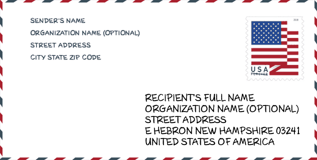
Envelop Voorbeeld

Dit is een voorbeeld van een Amerikaanse postenvelop. U kunt een 5-cijferige postcode of een gedetailleerde 9-cijferige postcode gebruiken om de mail in het volgende adresformaat te kopiëren.
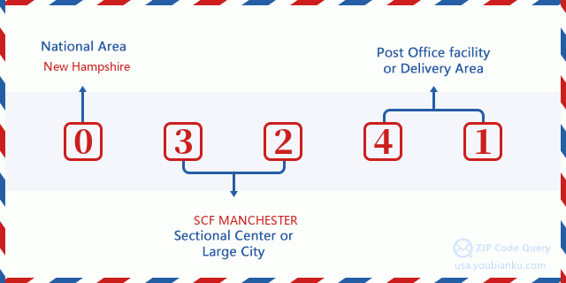
03241 Basisbetekenis
Waar staat elk cijfer van postcode 03241 voor? Het eerste cijfer geeft een nationaal gebied aan, dat varieert van nul voor het noordoosten tot negen voor het verre westen. De 2-3 cijfers zijn de code van een sectiecentrumfaciliteit in die regio. De laatste twee cijfers duiden kleine postkantoren of postzones aan.
Online landkaart

Het is een online kaart van adres Hebron, New Hampshire, United States. U kunt Knopje gebruiken te in/uitzoomen. De kaartinformatie is alleen ter referentie.
Population for Postcode 03241

What is the total population in ZIP Code 03241? Below is detail information.
- Population for Postcode 03241: 824
- 2010 Bevolking: 876
The 2020 demographic statistics are in progress. The current population in ZIP code 03241 is 824, and the population in 2010 is 876.
Geslacht

In all the statistical population, the male population is 452, the female population is 424.
- Male Population: 452
- Female Population: 424
Race

In all the statistical population, the male population is 452, the female population is 424.
- White Population: 862
- Black Population: 4
- Hispanic Population: 17
- Asian Population: 6
- Hawaiian Population: 0
- Indian Population: 10
- Other Population: 1
Leeftijd

In all the statistical population, the White population is 862, the Black population is 4, the Hispanic population is 17, the Asian population is 6, the Hawaiian population is 0, the Indian Ppopulation is 10 and Other population is 1.
- Age's Median: 52.5
- Median of male age: 52.8
- Median of female age: 52.3
Households for Postcode 03241
ZIP code 03241 has 391 households, with an average number of 2.21 persons per household. The average income per household in Zip code 03241 is 66,875 USD, and the average house value is 285,800 USD.
- Households Per Zipcode: 391
- Personen per huishouden: 2.21
- Gemiddelde huiswaarde: 285,800
- Inkomen per huishouden: 66,875
Geographic

The latitude of the Zip code 03241 is 43.721684, the longitude is -71.833959, and the elevation is 997. It has land area of 41.53 square miles, and water area of 2.311 square miles. The time zone for ZIP code 03241 is Eastern (GMT -05:00). Daylight saving time should be observed in the area where the zip code is located.
- Breedtegraad: 43.721684
- Lengte: -71.833959
- Elevatie: 997
- Landoppervlak: 41.53
- Water Area: 2.311
- Tijd Zone: Eastern (GMT -05:00)
- Regio: Northeast
- Divisie: New England
- Zomertijd: Y
congresdistrict

The Congressional District for ZIP code 03241 is New Hampshire's 2nd congressional district, the Congressional Land Area is 6489 square mile.
- congresdistrict: 2nd
- Congresgebied: 6489
Levering

In the ZIP code 03241, there are 373 residential delivery mailboxes and centralized units, and 16 commercial delivery mailbox and centralized units, 346 single family deliveries and 0 multifamily deliveries, and the box count is 601. The main post office does not have city delivery carrier routes for the ZIP code 03241.
- Delivery Residential: 373
- Delivery Business: 16
- Delivery Total: 601
- Leveringseenheden voor één gezin: 346
- Multi Family Delivery Units: 0
- Stadsleveringsindicator: N
Bedrijf

In ZIP code 03241, the number of business is 23, the number of employee is 88, the business first quarter payroll is 727,000 USD, the business annual payroll is 3,681,000 USD.
- Number Of Businesses: 23
- Number Of Employees: 88
- Zakelijke salarisadministratie eerste kwartaal: 727,000
- Zakelijke jaarlijkse loonlijst: 3,681,000


Reactie toevoegen