Verenigde Staten Postcode: 04401
Dit is de paginalijst van Maine Postcode 04401. Hieronder is het detail van Staat, Graafschap, Stad, Lengte, Breedtegraad, Envelop Voorbeeld, Bevolking.

Postcode 04401 Informatie

-
-
Land:
U.S. - Verenigde Staten
Staat:
Staat FIPS:
23
Netnummer:
Postcode:
04401
Postcode Type:
S (Standard)
❓Wat betekent S (Standard)? Een "standaard" postcode is waar de meeste mensen aan denken als ze het over postcodes hebben - in wezen een stad, een stad of een afdeling van een stad die een postdienst heeft.
Postcode 04401 - Stad

Dit is de stadsinformatie die overeenkomt met 04401:
| Staat | Graafschap | Stad | Stadtype ?In many cases, a ZIP Code can have multiple "names", meaning cities, towns, or subdivisions, in its boundaries. However, it will ALWAYS have exactly 1 "default" name. D - Default - This is the "preferred" name - by the USPS - for a city. Each ZIP Code has one - and only one - "default" name. In most cases, this is what people who live in that area call the city as well. A - Acceptable - This name can be used for mailing purposes. Often times alternative names are large neighborhoods or sections of the city/town. In some cases a ZIP Code may have several "acceptable" names which is used to group towns under one ZIP Code. N - Not Acceptable - A "not acceptable" name is, in many cases, a nickname that residents give that location. According to the USPS, you should NOT send mail to that ZIP Code using the "not acceptable" name when mailing. | Postcode |
|---|---|---|---|---|
| ME | Penobscot | Bangor | D (Default) | 04401 |
| ME | Penobscot | Glenburn | A (Acceptable) | 04401 |
| ME | Penobscot | Hermon | A (Acceptable) | 04401 |
| ME | Penobscot | Veazie | A (Acceptable) | 04401 |
❓Wat betekent D (Default)? Dit is de "geprefereerde" naam - door de USPS - voor een stad. Elke postcode heeft één - en slechts één - "standaard" naam. In de meeste gevallen noemen mensen die in dat gebied wonen de stad ook.
❓Wat betekent A (Acceptable)? Deze naam kan worden gebruikt voor mailingdoeleinden. Vaak zijn alternatieve namen grote buurten of delen van de stad / stad. In sommige gevallen kan een postcode meerdere "acceptabele" namen hebben die worden gebruikt om steden onder één postcode te groeperen.
Postcode 04401 Plus 4
ZIP Code 5 plus 4 is de uitbreiding van de 5-cijferige postcode, het kan worden gebruikt om een meer gedetailleerde locatie te vinden. De laatste vier cijfers duiden een segment of een kant van een straat of een appartement aan. Hieronder vindt u de postcode en het bijbehorende adres van de postcode 04401.
| Postcode 5 Plus 4 | Adres |
|---|---|
| 04401-0001 | 6100 MIDALEAR ST, GLENBURN, ME |
| 04401-0100 | 701 FULLER RD, HERMON, ME |
| 04401-0101 | 801 FULLER RD, HERMON, ME |
| 04401-0102 | 811 FULLER RD, HERMON, ME |
| 04401-0103 | 901 FULLER RD, HERMON, ME |
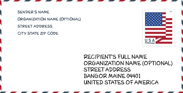
Envelop Voorbeeld

Dit is een voorbeeld van een Amerikaanse postenvelop. U kunt een 5-cijferige postcode of een gedetailleerde 9-cijferige postcode gebruiken om de mail in het volgende adresformaat te kopiëren.
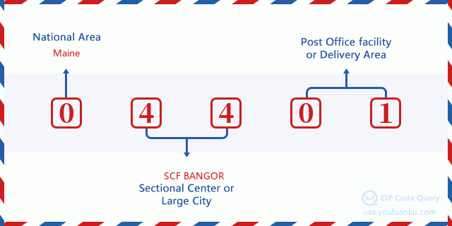
04401 Basisbetekenis
Waar staat elk cijfer van postcode 04401 voor? Het eerste cijfer geeft een nationaal gebied aan, dat varieert van nul voor het noordoosten tot negen voor het verre westen. De 2-3 cijfers zijn de code van een sectiecentrumfaciliteit in die regio. De laatste twee cijfers duiden kleine postkantoren of postzones aan.
Online landkaart

Het is een online kaart van adres Veazie, Maine, United States. U kunt Knopje gebruiken te in/uitzoomen. De kaartinformatie is alleen ter referentie.
Universiteit

This is the ZIP Code 04401 - University page list. Its detail university Name, Street, City, State, ZIP Code, Phone is as below.
| Naam | Straat | Stad | Staat | Postcode | Telefoon |
| Beal College | 99 Farm Road | Bangor | ME | 04401 | - |
| Eastern Maine Community College | 354 Hogan Rd | Bangor | ME | 04401 | (207) 974-4600 |
| New England School of Communications | 1 College Circle | Bangor | ME | 04401 | - |
| University of Maine-System Central Office | 16 Central Street | Bangor | ME | 04401 | - |
| Beal University | 99 Farm Road | Bangor | ME | 04401 | (207) 947-4591 |
| Empire Beauty School-Bangor | 639 Broadway | Bangor | ME | 04401 | (800) 920-4593 |
Ziekenhuis

Het is de Postcode 04401 - Ziekenhuis pagina lijst. Het detail Ziekenhuisnaam, straat, stad, staat, postcode, telefoon is zoals hieronder.
| Naam | Adres | Stad | Staat | Postcode | Telefoon |
|---|---|---|---|---|---|
| NORTHERN LIGHT ACADIA HOSPITAL | 268 STILLWATER AVE | BANGOR | ME | 04401 | (207) 973-6100 |
| DOROTHEA DIX PSYCHIATRIC CENTER | 656 STATE STREET | BANGOR | ME | 04401 | (207) 941-4000 |
| ST JOSEPH HOSPITAL | 360 BROADWAY | BANGOR | ME | 04401 | (207) 262-1000 |
| EASTERN MAINE MEDICAL CENTER | PO BOX 404 | BANGOR | ME | 04401 | (207) 973-7000 |
Museum

Dit is de paginalijst van Postcode 04401 - Museum. Hieronder is het detail van Museum Naam, Straat, Stad, Staat, Postcode, Telefoon.
| Naam | Straat | Stad | Staat | Postcode | Telefoon |
| COLE LAND TRANSPORTATION MUSEUM | 405 PERRY RD | BANGOR | ME | 04401 | (207) 990-3600 |
| HERMON HISTORICAL SOCIETY | 574 WING RD | HERMON | ME | 04401 | |
| BANGOR MUSEUM AND CENTER FOR HISTORY | 159 UNION STREET | BANGOR | ME | 04401 | (207) 942-1900 |
| MAINE DISCOVERY MUSEUM | 74 MAIN STREET | BANGOR | ME | 04401 | |
| JOHN ROHMAN ART GALLERY | 354 HOGAN RD | BANGOR | ME | 04401 | |
| WHITE ART GALLERY | 1 COLLEGE CIRCLE | BANGOR | ME | 04401 |
Bibliotheek

Dit is de paginalijst van Postcode 04401 - Bibliotheek. Hieronder is het detail van Bibliotheek Naam, Adres, Stad, Staat, Postcode, Telefoon.
- Naam: BANGOR PUBLIC LIBRARY
- Adres: 145 HARLOW STREET
- Stad: BANGOR
- Staat: ME - Maine
- Postcode: 04401
- Telefoon: (207) 947-8336
School
Dit is de paginalijst van Postcode 04401 - School. Hieronder is het detail van School Naam, Adres, Stad, Staat, Postcode.
| School Naam | Adres | Stad | Staat | Klassen | Postcode |
|---|---|---|---|---|---|
| Abraham Lincoln School | 45 Forest Avenue | Bangor | ME | UG | 04401 |
| Bangor High School | 885 Broadway | Bangor | ME | UG | 04401 |
| Downeast School | 100 Moosehead Blvd | Bangor | ME | UG | 04401 |
| Fairmount School | 58 Thirteenth Street | Bangor | ME | UG | 04401 |
| James F. Doughty School | 143 Fifth Street | Bangor | ME | UG | 04401 |
| Fruit Street School | 175 Fruit Street | Bangor | ME | UG | 04401 |
| William S. Cohen School | 304 Garland Street | Bangor | ME | UG | 04401 |
| Vine Street School | 66 Vine Street | Bangor | ME | UG | 04401 |
| Mary Snow School | 435 Broadway | Bangor | ME | UG | 04401 |
| Fourteenth Street School | 224 Fourteenth Street | Bangor | ME | UG | 04401 |
| Glenburn Elementary School | 991 Hudson Road | Glenburn | ME | UG | 04401 |
| Patricia A Duran School | 235 Billings Road | Hermon | ME | UG | 04401 |
| Hermon Middle School | 29 Billings Road | Hermon | ME | UG | 04401 |
| Hermon High School | 2415 Route 2 | Hermon | ME | UG | 04401 |
| United Technologies Ctr-Region 4 | 200 Hogan Road | Bangor | ME | UG | 04401 |
| Veazie Community School | 1040 School Street | Veazie | ME | UG | 04401 |
Population for Postcode 04401

What is the total population in ZIP Code 04401? Below is detail information.
- Population for Postcode 04401: 44,726
- 2010 Bevolking: 44,899
The 2020 demographic statistics are in progress. The current population in ZIP code 04401 is 44,726, and the population in 2010 is 44,899.
Geslacht

In all the statistical population, the male population is 21,732, the female population is 23,167.
- Male Population: 21,732
- Female Population: 23,167
Race

In all the statistical population, the male population is 21,732, the female population is 23,167.
- White Population: 43,004
- Black Population: 879
- Hispanic Population: 587
- Asian Population: 799
- Hawaiian Population: 46
- Indian Population: 837
- Other Population: 181
Leeftijd

In all the statistical population, the White population is 43,004, the Black population is 879, the Hispanic population is 587, the Asian population is 799, the Hawaiian population is 46, the Indian Ppopulation is 837 and Other population is 181.
- Age's Median: 38.2
- Median of male age: 35.9
- Median of female age: 40.1
Households for Postcode 04401
ZIP code 04401 has 19,159 households, with an average number of 2.20 persons per household. The average income per household in Zip code 04401 is 47,789 USD, and the average house value is 157,700 USD.
- Households Per Zipcode: 19,159
- Personen per huishouden: 2.20
- Gemiddelde huiswaarde: 157,700
- Inkomen per huishouden: 47,789
Geographic

The latitude of the Zip code 04401 is 44.863639, the longitude is -68.815722, and the elevation is 122. It has land area of 100.215 square miles, and water area of 6.303 square miles. The time zone for ZIP code 04401 is Eastern (GMT -05:00). Daylight saving time should be observed in the area where the zip code is located.
- Breedtegraad: 44.863639
- Lengte: -68.815722
- Elevatie: 122
- Landoppervlak: 100.215
- Water Area: 6.303
- Tijd Zone: Eastern (GMT -05:00)
- Regio: Northeast
- Divisie: New England
- Zomertijd: Y
congresdistrict

The Congressional District for ZIP code 04401 is Maine's 2nd congressional district, the Congressional Land Area is 27557.4 square mile.
- congresdistrict: 2nd
- Congresgebied: 27557.4
Levering

In the ZIP code 04401, there are 20,330 residential delivery mailboxes and centralized units, and 2,139 commercial delivery mailbox and centralized units, 15,135 single family deliveries and 2,101 multifamily deliveries, and the box count is 22,638. The main post office has city delivery carrier routes for the ZIP code 04401.
- Delivery Residential: 20,330
- Delivery Business: 2,139
- Delivery Total: 22,638
- Leveringseenheden voor één gezin: 15,135
- Multi Family Delivery Units: 2,101
- Stadsleveringsindicator: Y
Bedrijf

In ZIP code 04401, the number of business is 1,807, the number of employee is 33,779, the business first quarter payroll is 372,251,000 USD, the business annual payroll is 1,508,822,000 USD.
- Number Of Businesses: 1,807
- Number Of Employees: 33,779
- Zakelijke salarisadministratie eerste kwartaal: 372,251,000
- Zakelijke jaarlijkse loonlijst: 1,508,822,000


Reactie toevoegen