Postcode: 06002, Bloomfield, CT
Postcode 06002 bevindt zich in Bloomfield, Connecticut. Het detail staat, provincie, stad, lengtegraad, breedtegraad, envelop Voorbeeld, Bevolking is zoals hieronder.

Postcode 06002 Informatie

-
-
Land:
U.S. - Verenigde Staten
Staat:
Regio FIPS:
09003
Graafschap:
Stad:
Netnummer:
Stadtype ?In many cases, a ZIP Code can have multiple "names", meaning cities, towns, or subdivisions, in its boundaries. However, it will ALWAYS have exactly 1 "default" name. D - Default - This is the "preferred" name - by the USPS - for a city. Each ZIP Code has one - and only one - "default" name. In most cases, this is what people who live in that area call the city as well. A - Acceptable - This name can be used for mailing purposes. Often times alternative names are large neighborhoods or sections of the city/town. In some cases a ZIP Code may have several "acceptable" names which is used to group towns under one ZIP Code. N - Not Acceptable - A "not acceptable" name is, in many cases, a nickname that residents give that location. According to the USPS, you should NOT send mail to that ZIP Code using the "not acceptable" name when mailing.:
D (Default)
Postcode:
06002
❓Wat betekent D (Default)? Dit is de "geprefereerde" naam - door de USPS - voor een stad. Elke postcode heeft één - en slechts één - "standaard" naam. In de meeste gevallen noemen mensen die in dat gebied wonen de stad ook.
Postcode 06002 Plus 4
ZIP Code 5 plus 4 is de uitbreiding van de 5-cijferige postcode, het kan worden gebruikt om een meer gedetailleerde locatie te vinden. De laatste vier cijfers duiden een segment of een kant van een straat of een appartement aan. Hieronder vindt u de postcode en het bijbehorende adres van de postcode 06002.
| Postcode 5 Plus 4 | Adres |
|---|---|
| 06002-0021 | PO BOX 21, BLOOMFIELD, CT |
| 06002-0035 | PO BOX 0, BLOOMFIELD, CT |
| 06002-0036 | PO BOX 0, BLOOMFIELD, CT |
| 06002-0037 | PO BOX 0, BLOOMFIELD, CT |
| 06002-0038 | PO BOX 0, BLOOMFIELD, CT |
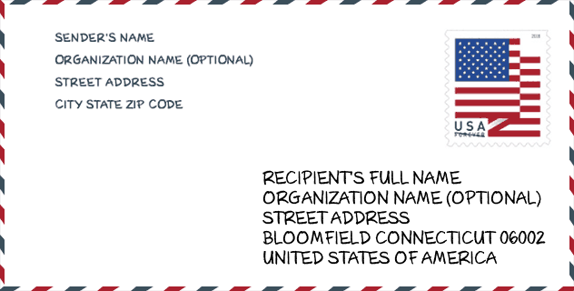
Envelop Voorbeeld

Dit is een voorbeeld van een Amerikaanse postenvelop. U kunt een 5-cijferige postcode of een gedetailleerde 9-cijferige postcode gebruiken om de mail in het volgende adresformaat te kopiëren.
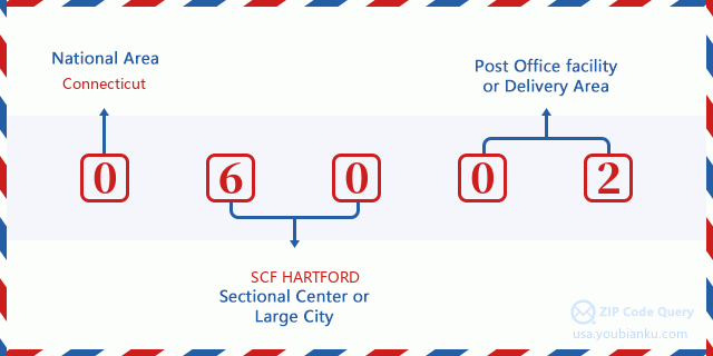
06002 Basisbetekenis
Waar staat elk cijfer van postcode 06002 voor? Het eerste cijfer geeft een nationaal gebied aan, dat varieert van nul voor het noordoosten tot negen voor het verre westen. De 2-3 cijfers zijn de code van een sectiecentrumfaciliteit in die regio. De laatste twee cijfers duiden kleine postkantoren of postzones aan.
Online landkaart

Het is een online kaart van adres Bloomfield, Connecticut, United States. U kunt Knopje gebruiken te in/uitzoomen. De kaartinformatie is alleen ter referentie.
Museum

Dit is de paginalijst van Postcode 06002 - Museum. Hieronder is het detail van Museum Naam, Straat, Stad, Staat, Postcode, Telefoon.
| Naam | Straat | Stad | Staat | Postcode | Telefoon |
| BLOOMFIELD FARM IMPLEMENT MUSEUM | 434 TUNXIS AVE | BLOOMFIELD | CT | 06002 | |
| WINTONBURY HISTORICAL SOCIETY | 14 JULIE LN | BLOOMFIELD | CT | 06002 | (860) 243-1531 |
Bibliotheek

Dit is de paginalijst van Postcode 06002 - Bibliotheek. Hieronder is het detail van Bibliotheek Naam, Adres, Stad, Staat, Postcode, Telefoon.
| Naam | Adres | Stad | Staat | Postcode | Telefoon |
|---|---|---|---|---|---|
| PROSSER PUBLIC LIBRARY | 1 TUNXIS AVE. | BLOOMFIELD | CT | 06002 | (860) 243-9721 |
| WINTONBURY BRANCH LIBRARY | 1015 BLUE HILLS AVE. | BLOOMFIELD | CT | 06002 | (860) 242-0041 |
School

Dit is de paginalijst van Postcode 06002 - School. Hieronder is het detail van School Naam, Adres, Stad, Staat, Postcode.
| School Naam | Adres | Stad | Staat | Klassen | Postcode |
|---|---|---|---|---|---|
| Wintonbury Early Childhood Magnet School | 44 Brown Street | Bloomfield | CT | UG | 06002 |
| Global Experience Magnet School | 44 Griffin Rd. | Bloomfield | CT | UG | 06002 |
| Metropolitan Learning Center for Global and International St | 1551 Blue Hills Ave. | Bloomfield | CT | UG | 06002 |
| Museum Academy | 11 Turkey Hill Road | Bloomfield | CT | UG | 06002 |
Population for Postcode 06002

What is the total population in ZIP Code 06002? Below is detail information.
- Population for Postcode 06002: 22,276
- 2010 Bevolking: 20,486
The 2020 demographic statistics are in progress. The current population in ZIP code 06002 is 22,276, and the population in 2010 is 20,486.
Geslacht

In all the statistical population, the male population is 9,199, the female population is 11,287.
- Male Population: 9,199
- Female Population: 11,287
Race

In all the statistical population, the male population is 9,199, the female population is 11,287.
- White Population: 7,654
- Black Population: 12,253
- Hispanic Population: 1,149
- Asian Population: 507
- Hawaiian Population: 35
- Indian Population: 245
- Other Population: 489
Leeftijd

In all the statistical population, the White population is 7,654, the Black population is 12,253, the Hispanic population is 1,149, the Asian population is 507, the Hawaiian population is 35, the Indian Ppopulation is 245 and Other population is 489.
- Age's Median: 47.9
- Median of male age: 44.7
- Median of female age: 50.3
Households for Postcode 06002
ZIP code 06002 has 8,554 households, with an average number of 2.32 persons per household. The average income per household in Zip code 06002 is 76,952 USD, and the average house value is 216,800 USD.
- Households Per Zipcode: 8,554
- Personen per huishouden: 2.32
- Gemiddelde huiswaarde: 216,800
- Inkomen per huishouden: 76,952
Geographic

The latitude of the Zip code 06002 is 41.852981, the longitude is -72.736005, and the elevation is 129. It has land area of 26.063 square miles, and water area of 0.165 square miles. The time zone for ZIP code 06002 is Eastern (GMT -05:00). Daylight saving time should be observed in the area where the zip code is located.
- Breedtegraad: 41.852981
- Lengte: -72.736005
- Elevatie: 129
- Landoppervlak: 26.063
- Water Area: 0.165
- Tijd Zone: Eastern (GMT -05:00)
- Regio: Northeast
- Divisie: New England
- Zomertijd: Y
congresdistrict

The Congressional District for ZIP code 06002 is Connecticut's 1st congressional district, the Congressional Land Area is 675.45 square mile.
- congresdistrict: 1st
- Congresgebied: 675.45
Levering

In the ZIP code 06002, there are 9,602 residential delivery mailboxes and centralized units, and 999 commercial delivery mailbox and centralized units, 6,722 single family deliveries and 1,719 multifamily deliveries, and the box count is 11,259. The main post office has city delivery carrier routes for the ZIP code 06002.
- Delivery Residential: 9,602
- Delivery Business: 999
- Delivery Total: 11,259
- Leveringseenheden voor één gezin: 6,722
- Multi Family Delivery Units: 1,719
- Stadsleveringsindicator: Y
Bedrijf

In ZIP code 06002, the number of business is 701, the number of employee is 15,932, the business first quarter payroll is 267,686,000 USD, the business annual payroll is 1,067,224,000 USD.
- Number Of Businesses: 701
- Number Of Employees: 15,932
- Zakelijke salarisadministratie eerste kwartaal: 267,686,000
- Zakelijke jaarlijkse loonlijst: 1,067,224,000


Reactie toevoegen