Verenigde Staten Postcode: 06320
Dit is de paginalijst van Connecticut Postcode 06320. Hieronder is het detail van Staat, Graafschap, Stad, Lengte, Breedtegraad, Envelop Voorbeeld, Bevolking.

Postcode 06320 Informatie

-
-
Land:
U.S. - Verenigde Staten
Staat:
Staat FIPS:
09
Postcode:
06320
Postcode Type:
S (Standard)
❓Wat betekent S (Standard)? Een "standaard" postcode is waar de meeste mensen aan denken als ze het over postcodes hebben - in wezen een stad, een stad of een afdeling van een stad die een postdienst heeft.
Postcode 06320 - Stad

Dit is de stadsinformatie die overeenkomt met 06320:
| Staat | Graafschap | Stad | Stadtype ?In many cases, a ZIP Code can have multiple "names", meaning cities, towns, or subdivisions, in its boundaries. However, it will ALWAYS have exactly 1 "default" name. D - Default - This is the "preferred" name - by the USPS - for a city. Each ZIP Code has one - and only one - "default" name. In most cases, this is what people who live in that area call the city as well. A - Acceptable - This name can be used for mailing purposes. Often times alternative names are large neighborhoods or sections of the city/town. In some cases a ZIP Code may have several "acceptable" names which is used to group towns under one ZIP Code. N - Not Acceptable - A "not acceptable" name is, in many cases, a nickname that residents give that location. According to the USPS, you should NOT send mail to that ZIP Code using the "not acceptable" name when mailing. | Postcode |
|---|---|---|---|---|
| CT | New London | Ft Trumbull | N (Not Acceptable) | 06320 |
| CT | New London | New London | D (Default) | 06320 |
| CT | New London | United States Coast Guard | N (Not Acceptable) | 06320 |
| CT | New London | Us Coast Guard Acad | N (Not Acceptable) | 06320 |
❓Wat betekent D (Default)? Dit is de "geprefereerde" naam - door de USPS - voor een stad. Elke postcode heeft één - en slechts één - "standaard" naam. In de meeste gevallen noemen mensen die in dat gebied wonen de stad ook.
❓Wat betekent N (Not Acceptable)? Een "niet acceptabele" naam is in veel gevallen een bijnaam die bewoners aan die locatie geven. Volgens de USPS mag je GEEN post naar die postcode sturen met de "niet acceptabele" naam bij het mailen.
Postcode 06320 Plus 4
ZIP Code 5 plus 4 is de uitbreiding van de 5-cijferige postcode, het kan worden gebruikt om een meer gedetailleerde locatie te vinden. De laatste vier cijfers duiden een segment of een kant van een straat of een appartement aan. Hieronder vindt u de postcode en het bijbehorende adres van de postcode 06320.
| Postcode 5 Plus 4 | Adres |
|---|---|
| 06320-0001 | PO BOX 1, NEW LONDON, CT |
| 06320-0121 | PO BOX 121, NEW LONDON, CT |
| 06320-0281 | PO BOX 281, NEW LONDON, CT |
| 06320-0441 | PO BOX 441, NEW LONDON, CT |
| 06320-0601 | PO BOX 601, NEW LONDON, CT |
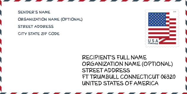
Envelop Voorbeeld

Dit is een voorbeeld van een Amerikaanse postenvelop. U kunt een 5-cijferige postcode of een gedetailleerde 9-cijferige postcode gebruiken om de mail in het volgende adresformaat te kopiëren.
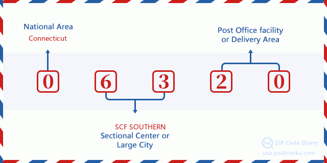
06320 Basisbetekenis
Waar staat elk cijfer van postcode 06320 voor? Het eerste cijfer geeft een nationaal gebied aan, dat varieert van nul voor het noordoosten tot negen voor het verre westen. De 2-3 cijfers zijn de code van een sectiecentrumfaciliteit in die regio. De laatste twee cijfers duiden kleine postkantoren of postzones aan.
Online landkaart

Het is een online kaart van adres Us Coast Guard Acad, Connecticut, United States. U kunt Knopje gebruiken te in/uitzoomen. De kaartinformatie is alleen ter referentie.
Universiteit

This is the ZIP Code 06320 - University page list. Its detail university Name, Street, City, State, ZIP Code, Phone is as below.
| Naam | Straat | Stad | Staat | Postcode | Telefoon |
| Mitchell College | 437 Pequot Avenue | New London | CT | 06320 | (860) 701-5000 |
| Ridley-Lowell Business & Technical Institute-New London | 470 Bank Street | New London | CT | 06320 | - |
Ziekenhuis

Het is de Postcode 06320 - Ziekenhuis pagina lijst. Het detail Ziekenhuisnaam, straat, stad, staat, postcode, telefoon is zoals hieronder.
- Naam: LAWRENCE & MEMORIAL HOSPITAL
- Adres: NEW LONDON
- Stad: 365 MONTAUK AVE
- Staat: CT
- Postcode: 06320
- Telefoon: (860) 442-0711
Museum

Dit is de paginalijst van Postcode 06320 - Museum. Hieronder is het detail van Museum Naam, Straat, Stad, Staat, Postcode, Telefoon.
| Naam | Straat | Stad | Staat | Postcode | Telefoon |
| SCIENCE CENTER OF EASTERN CONNECTICUT | 33 GALLOWS LN | NEW LONDON | CT | 06320 | (860) 442-0391 |
| NEW LONDON MARITIME SOCIETY | 150 BANK ST | NEW LONDON | CT | 06320 | (860) 235-4829 |
| CONNECTICUT COLLEGE ARBORETUM | 270 MOHEGAN AVENUE PARKWAY | NEW LONDON | CT | 06320 | (860) 439-5020 |
| CUMMINGS ART GALLERIES | 270 MOHEGAN AVENUE PARKWAY | NEW LONDON | CT | 06320 | (860) 447-1911 |
Bibliotheek

Dit is de paginalijst van Postcode 06320 - Bibliotheek. Hieronder is het detail van Bibliotheek Naam, Adres, Stad, Staat, Postcode, Telefoon.
- Naam: PUBLIC LIBRARY OF NEW LONDON
- Adres: 63 HUNTINGTON ST.
- Stad: NEW LONDON
- Staat: CT - Connecticut
- Postcode: 06320
- Telefoon: (860) 447-1411
School
Dit is de paginalijst van Postcode 06320 - School. Hieronder is het detail van School Naam, Adres, Stad, Staat, Postcode.
| School Naam | Adres | Stad | Staat | Klassen | Postcode |
|---|---|---|---|---|---|
| Interdistrict School For Arts And Communication | 190 Governor Winthrop Blvd. | New London | CT | UG | 06320 |
| C.B. Jennings International Elementary Magnet | 50 Mercer Street | New London | CT | UG | 06320 |
| New London High School | 490 Jefferson Ave. | New London | CT | UG | 06320 |
| Winthrop STEM Elementary Magnet School | 74 Grove Street | New London | CT | UG | 06320 |
| Science and Technology Magnet Pathway for High School Grades | 490 Jefferson Ave | New London | CT | UG | 06320 |
| New London Visual and Performing Arts Magnet School | 36 Waller Street | New London | CT | UG | 06320 |
| Science and Technology Magnet Pathway for Middle Grades | 36 Waller Avenue | New London | CT | UG | 06320 |
| Regional Multicultural Magnet School | One Bulkeley Place | New London | CT | UG | 06320 |
Population for Postcode 06320

What is the total population in ZIP Code 06320? Below is detail information.
- Population for Postcode 06320: 25,182
- 2010 Bevolking: 27,617
The 2020 demographic statistics are in progress. The current population in ZIP code 06320 is 25,182, and the population in 2010 is 27,617.
Geslacht

In all the statistical population, the male population is 13,640, the female population is 13,977.
- Male Population: 13,640
- Female Population: 13,977
Race

In all the statistical population, the male population is 13,640, the female population is 13,977.
- White Population: 18,058
- Black Population: 5,913
- Hispanic Population: 7,815
- Asian Population: 1,022
- Hawaiian Population: 164
- Indian Population: 767
- Other Population: 3,801
Leeftijd

In all the statistical population, the White population is 18,058, the Black population is 5,913, the Hispanic population is 7,815, the Asian population is 1,022, the Hawaiian population is 164, the Indian Ppopulation is 767 and Other population is 3,801.
- Age's Median: 30.3
- Median of male age: 29.1
- Median of female age: 31.6
Households for Postcode 06320
ZIP code 06320 has 10,373 households, with an average number of 2.30 persons per household. The average income per household in Zip code 06320 is 39,721 USD, and the average house value is 181,300 USD.
- Households Per Zipcode: 10,373
- Personen per huishouden: 2.30
- Gemiddelde huiswaarde: 181,300
- Inkomen per huishouden: 39,721
Geographic

The latitude of the Zip code 06320 is 41.345754, the longitude is -72.105722, and the elevation is 56. It has land area of 5.535 square miles, and water area of 1.987 square miles. The time zone for ZIP code 06320 is Eastern (GMT -05:00). Daylight saving time should be observed in the area where the zip code is located.
- Breedtegraad: 41.345754
- Lengte: -72.105722
- Elevatie: 56
- Landoppervlak: 5.535
- Water Area: 1.987
- Tijd Zone: Eastern (GMT -05:00)
- Regio: Northeast
- Divisie: New England
- Zomertijd: Y
congresdistrict

The Congressional District for ZIP code 06320 is Connecticut's 2nd congressional district, the Congressional Land Area is 1987.68 square mile.
- congresdistrict: 2nd
- Congresgebied: 1987.68
Levering

In the ZIP code 06320, there are 10,949 residential delivery mailboxes and centralized units, and 1,091 commercial delivery mailbox and centralized units, 6,945 single family deliveries and 1,971 multifamily deliveries, and the box count is 12,603. The main post office has city delivery carrier routes for the ZIP code 06320.
- Delivery Residential: 10,949
- Delivery Business: 1,091
- Delivery Total: 12,603
- Leveringseenheden voor één gezin: 6,945
- Multi Family Delivery Units: 1,971
- Stadsleveringsindicator: Y
Bedrijf

In ZIP code 06320, the number of business is 716, the number of employee is 13,286, the business first quarter payroll is 159,535,000 USD, the business annual payroll is 679,052,000 USD.
- Number Of Businesses: 716
- Number Of Employees: 13,286
- Zakelijke salarisadministratie eerste kwartaal: 159,535,000
- Zakelijke jaarlijkse loonlijst: 679,052,000


Reactie toevoegen