Postcode: 06405, Branford, CT
Postcode 06405 bevindt zich in Branford, Connecticut. Het detail staat, provincie, stad, lengtegraad, breedtegraad, envelop Voorbeeld, Bevolking is zoals hieronder.

Postcode 06405 Informatie

-
-
Land:
U.S. - Verenigde Staten
Staat:
Regio FIPS:
09009
Graafschap:
Stad:
Stadtype ?In many cases, a ZIP Code can have multiple "names", meaning cities, towns, or subdivisions, in its boundaries. However, it will ALWAYS have exactly 1 "default" name. D - Default - This is the "preferred" name - by the USPS - for a city. Each ZIP Code has one - and only one - "default" name. In most cases, this is what people who live in that area call the city as well. A - Acceptable - This name can be used for mailing purposes. Often times alternative names are large neighborhoods or sections of the city/town. In some cases a ZIP Code may have several "acceptable" names which is used to group towns under one ZIP Code. N - Not Acceptable - A "not acceptable" name is, in many cases, a nickname that residents give that location. According to the USPS, you should NOT send mail to that ZIP Code using the "not acceptable" name when mailing.:
D (Default)
Postcode:
06405
❓Wat betekent D (Default)? Dit is de "geprefereerde" naam - door de USPS - voor een stad. Elke postcode heeft één - en slechts één - "standaard" naam. In de meeste gevallen noemen mensen die in dat gebied wonen de stad ook.
Postcode 06405 Plus 4
ZIP Code 5 plus 4 is de uitbreiding van de 5-cijferige postcode, het kan worden gebruikt om een meer gedetailleerde locatie te vinden. De laatste vier cijfers duiden een segment of een kant van een straat of een appartement aan. Hieronder vindt u de postcode en het bijbehorende adres van de postcode 06405.
| Postcode 5 Plus 4 | Adres |
|---|---|
| 06405-0001 | PO BOX 1, BRANFORD, CT |
| 06405-0121 | PO BOX 121, BRANFORD, CT |
| 06405-0241 | PO BOX 241, BRANFORD, CT |
| 06405-0361 | PO BOX 361, BRANFORD, CT |
| 06405-0473 | PO BOX 473, BRANFORD, CT |
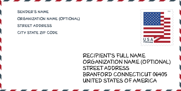
Envelop Voorbeeld

Dit is een voorbeeld van een Amerikaanse postenvelop. U kunt een 5-cijferige postcode of een gedetailleerde 9-cijferige postcode gebruiken om de mail in het volgende adresformaat te kopiëren.
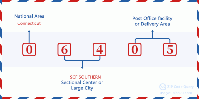
06405 Basisbetekenis
Waar staat elk cijfer van postcode 06405 voor? Het eerste cijfer geeft een nationaal gebied aan, dat varieert van nul voor het noordoosten tot negen voor het verre westen. De 2-3 cijfers zijn de code van een sectiecentrumfaciliteit in die regio. De laatste twee cijfers duiden kleine postkantoren of postzones aan.
Online landkaart

Het is een online kaart van adres Branford, Connecticut, United States. U kunt Knopje gebruiken te in/uitzoomen. De kaartinformatie is alleen ter referentie.
Universiteit

This is the ZIP Code 06405 - University page list. Its detail university Name, Street, City, State, ZIP Code, Phone is as below.
| Naam | Straat | Stad | Staat | Postcode | Telefoon |
| Branford Academy of Hair and Cosmetology | 251 West Main St | Branford | CT | 06405 | (203) 315-2985 |
| Branford Hall Career Institute-Branford Campus | One Summit Place | Branford | CT | 06405 | - |
Ziekenhuis

Het is de Postcode 06405 - Ziekenhuis pagina lijst. Het detail Ziekenhuisnaam, straat, stad, staat, postcode, telefoon is zoals hieronder.
- Naam: THE CONNECTICUT HOSPICE INC.
- Adres: BRANFORD
- Stad: 100 DOUBLE BEACH ROAD
- Staat: CT
- Postcode: 06405
- Telefoon: (203) 315-7500
Museum

Dit is de paginalijst van Postcode 06405 - Museum. Hieronder is het detail van Museum Naam, Straat, Stad, Staat, Postcode, Telefoon.
| Naam | Straat | Stad | Staat | Postcode | Telefoon |
| STONY CREEK MUSEUM | 84 THIMBLE ISLAND RD | BRANFORD | CT | 06405 | (203) 481-9369 |
| BRANFORD HISTORICAL SOCIETY | PO BOX 504 | BRANFORD | CT | 06405 | (203) 488-4828 |
Bibliotheek

Dit is de paginalijst van Postcode 06405 - Bibliotheek. Hieronder is het detail van Bibliotheek Naam, Adres, Stad, Staat, Postcode, Telefoon.
| Naam | Adres | Stad | Staat | Postcode | Telefoon |
|---|---|---|---|---|---|
| JAMES BLACKSTONE MEMORIAL LIBRARY | 758 MAIN ST. | BRANFORD | CT | 06405 | (203) 488-1441 |
| WILLOUGHBY WALLACE MEMORIAL LIBRARY | 146 THIMBLE ISLANDS ROAD | STONY CREEK | CT | 06405 | (203) 488-8702 |
| WILLOUGHBY WALLACE MEMORIAL LIBRARY | 146 THIMBLE ISLANDS ROAD | BRANFORD | CT | 06405 | (203) 488-8702 |
Population for Postcode 06405

What is the total population in ZIP Code 06405? Below is detail information.
- Population for Postcode 06405: 29,338
- 2010 Bevolking: 27,860
The 2020 demographic statistics are in progress. The current population in ZIP code 06405 is 29,338, and the population in 2010 is 27,860.
Geslacht

In all the statistical population, the male population is 13,101, the female population is 14,759.
- Male Population: 13,101
- Female Population: 14,759
Race

In all the statistical population, the male population is 13,101, the female population is 14,759.
- White Population: 25,930
- Black Population: 679
- Hispanic Population: 1,147
- Asian Population: 1,133
- Hawaiian Population: 17
- Indian Population: 164
- Other Population: 341
Leeftijd

In all the statistical population, the White population is 25,930, the Black population is 679, the Hispanic population is 1,147, the Asian population is 1,133, the Hawaiian population is 17, the Indian Ppopulation is 164 and Other population is 341.
- Age's Median: 47.0
- Median of male age: 45.3
- Median of female age: 48.4
Households for Postcode 06405
ZIP code 06405 has 12,679 households, with an average number of 2.18 persons per household. The average income per household in Zip code 06405 is 80,073 USD, and the average house value is 293,500 USD.
- Households Per Zipcode: 12,679
- Personen per huishouden: 2.18
- Gemiddelde huiswaarde: 293,500
- Inkomen per huishouden: 80,073
Geographic

The latitude of the Zip code 06405 is 41.283154, the longitude is -72.796443, and the elevation is 14. It has land area of 21.252 square miles, and water area of 4.883 square miles. The time zone for ZIP code 06405 is Eastern (GMT -05:00). Daylight saving time should be observed in the area where the zip code is located.
- Breedtegraad: 41.283154
- Lengte: -72.796443
- Elevatie: 14
- Landoppervlak: 21.252
- Water Area: 4.883
- Tijd Zone: Eastern (GMT -05:00)
- Regio: Northeast
- Divisie: New England
- Zomertijd: Y
congresdistrict

The Congressional District for ZIP code 06405 is Connecticut's 3rd congressional district, the Congressional Land Area is 470.34 square mile.
- congresdistrict: 3rd
- Congresgebied: 470.34
Levering

In the ZIP code 06405, there are 13,458 residential delivery mailboxes and centralized units, and 1,275 commercial delivery mailbox and centralized units, 9,580 single family deliveries and 1,266 multifamily deliveries, and the box count is 15,257. The main post office has city delivery carrier routes for the ZIP code 06405.
- Delivery Residential: 13,458
- Delivery Business: 1,275
- Delivery Total: 15,257
- Leveringseenheden voor één gezin: 9,580
- Multi Family Delivery Units: 1,266
- Stadsleveringsindicator: Y
Bedrijf

In ZIP code 06405, the number of business is 988, the number of employee is 13,509, the business first quarter payroll is 149,170,000 USD, the business annual payroll is 633,939,000 USD.
- Number Of Businesses: 988
- Number Of Employees: 13,509
- Zakelijke salarisadministratie eerste kwartaal: 149,170,000
- Zakelijke jaarlijkse loonlijst: 633,939,000


Reactie toevoegen