Verenigde Staten Postcode: 07112
Dit is de paginalijst van New Jersey Postcode 07112. Hieronder is het detail van Staat, Graafschap, Stad, Lengte, Breedtegraad, Envelop Voorbeeld, Bevolking.

Postcode 07112 Informatie

-
-
Land:
U.S. - Verenigde Staten
Staat:
Staat FIPS:
34
Netnummer:
Postcode:
07112
Postcode Type:
S (Standard)
❓Wat betekent S (Standard)? Een "standaard" postcode is waar de meeste mensen aan denken als ze het over postcodes hebben - in wezen een stad, een stad of een afdeling van een stad die een postdienst heeft.
Postcode 07112 - Stad

Dit is de stadsinformatie die overeenkomt met 07112:
| Staat | Graafschap | Stad | Stadtype ?In many cases, a ZIP Code can have multiple "names", meaning cities, towns, or subdivisions, in its boundaries. However, it will ALWAYS have exactly 1 "default" name. D - Default - This is the "preferred" name - by the USPS - for a city. Each ZIP Code has one - and only one - "default" name. In most cases, this is what people who live in that area call the city as well. A - Acceptable - This name can be used for mailing purposes. Often times alternative names are large neighborhoods or sections of the city/town. In some cases a ZIP Code may have several "acceptable" names which is used to group towns under one ZIP Code. N - Not Acceptable - A "not acceptable" name is, in many cases, a nickname that residents give that location. According to the USPS, you should NOT send mail to that ZIP Code using the "not acceptable" name when mailing. | Postcode |
|---|---|---|---|---|
| NJ | Essex | Newark | D (Default) | 07112 |
| NJ | Essex | Weequahic | N (Not Acceptable) | 07112 |
❓Wat betekent D (Default)? Dit is de "geprefereerde" naam - door de USPS - voor een stad. Elke postcode heeft één - en slechts één - "standaard" naam. In de meeste gevallen noemen mensen die in dat gebied wonen de stad ook.
❓Wat betekent N (Not Acceptable)? Een "niet acceptabele" naam is in veel gevallen een bijnaam die bewoners aan die locatie geven. Volgens de USPS mag je GEEN post naar die postcode sturen met de "niet acceptabele" naam bij het mailen.
Postcode 07112 Plus 4
ZIP Code 5 plus 4 is de uitbreiding van de 5-cijferige postcode, het kan worden gebruikt om een meer gedetailleerde locatie te vinden. De laatste vier cijfers duiden een segment of een kant van een straat of een appartement aan. Hieronder vindt u de postcode en het bijbehorende adres van de postcode 07112.
| Postcode 5 Plus 4 | Adres |
|---|---|
| 07112-0001 | PO BOX 4001, NEWARK, NJ |
| 07112-0061 | PO BOX 4061, NEWARK, NJ |
| 07112-0072 | PO BOX 4072, NEWARK, NJ |
| 07112-0073 | PO BOX 4073, NEWARK, NJ |
| 07112-0200 | PO BOX 2207, NEWARK, NJ |
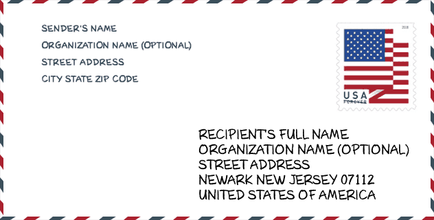
Envelop Voorbeeld

Dit is een voorbeeld van een Amerikaanse postenvelop. U kunt een 5-cijferige postcode of een gedetailleerde 9-cijferige postcode gebruiken om de mail in het volgende adresformaat te kopiëren.
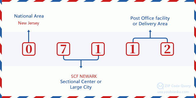
07112 Basisbetekenis
Waar staat elk cijfer van postcode 07112 voor? Het eerste cijfer geeft een nationaal gebied aan, dat varieert van nul voor het noordoosten tot negen voor het verre westen. De 2-3 cijfers zijn de code van een sectiecentrumfaciliteit in die regio. De laatste twee cijfers duiden kleine postkantoren of postzones aan.
Online landkaart

Het is een online kaart van adres Weequahic, New Jersey, United States. U kunt Knopje gebruiken te in/uitzoomen. De kaartinformatie is alleen ter referentie.
Ziekenhuis

Het is de Postcode 07112 - Ziekenhuis pagina lijst. Het detail Ziekenhuisnaam, straat, stad, staat, postcode, telefoon is zoals hieronder.
- Naam: NEWARK BETH ISRAEL MEDICAL CENTER
- Adres: NEWARK
- Stad: 201 LYONS AVE
- Staat: NJ
- Postcode: 07112
- Telefoon: (973) 926-7850
Bibliotheek

Dit is de paginalijst van Postcode 07112 - Bibliotheek. Hieronder is het detail van Bibliotheek Naam, Adres, Stad, Staat, Postcode, Telefoon.
- Naam: WEEQUAHIC BRANCH
- Adres: 355 OSBORNE TERR.
- Stad: NEWARK
- Staat: NJ - New Jersey
- Postcode: 07112
- Telefoon: (201) 733-7800
School

Dit is de paginalijst van Postcode 07112 - School. Hieronder is het detail van School Naam, Adres, Stad, Staat, Postcode.
| School Naam | Adres | Stad | Staat | Klassen | Postcode |
|---|---|---|---|---|---|
| Peshine Avenue School | 433 Peshine Avenue | NEWARK | NJ | UG | 07112 |
| Hawthorne Avenue School | 428 HAWTHORNE AVE | NEWARK | NJ | UG | 07112 |
| Early Childhood School - South | 255 Chancellor Avenue | NEWARK | NJ | UG | 07112 |
| Eagle Academy for Young Men of Newark | 279 Chancellor Avenue | Newark | NJ | UG | 07112 |
Population for Postcode 07112

What is the total population in ZIP Code 07112? Below is detail information.
- Population for Postcode 07112: 23,925
- 2010 Bevolking: 26,417
The 2020 demographic statistics are in progress. The current population in ZIP code 07112 is 23,925, and the population in 2010 is 26,417.
Geslacht

In all the statistical population, the male population is 11,891, the female population is 14,526.
- Male Population: 11,891
- Female Population: 14,526
Race

In all the statistical population, the male population is 11,891, the female population is 14,526.
- White Population: 854
- Black Population: 24,854
- Hispanic Population: 1,531
- Asian Population: 138
- Hawaiian Population: 32
- Indian Population: 205
- Other Population: 815
Leeftijd

In all the statistical population, the White population is 854, the Black population is 24,854, the Hispanic population is 1,531, the Asian population is 138, the Hawaiian population is 32, the Indian Ppopulation is 205 and Other population is 815.
- Age's Median: 33.5
- Median of male age: 31.2
- Median of female age: 35.2
Households for Postcode 07112
ZIP code 07112 has 9,837 households, with an average number of 2.67 persons per household. The average income per household in Zip code 07112 is 35,680 USD, and the average house value is 229,500 USD.
- Households Per Zipcode: 9,837
- Personen per huishouden: 2.67
- Gemiddelde huiswaarde: 229,500
- Inkomen per huishouden: 35,680
Geographic

The latitude of the Zip code 07112 is 40.710512, the longitude is -74.210148, and the elevation is 122. It has land area of 1.802 square miles, and water area of 0 square miles. The time zone for ZIP code 07112 is Eastern (GMT -05:00). Daylight saving time should be observed in the area where the zip code is located.
- Breedtegraad: 40.710512
- Lengte: -74.210148
- Elevatie: 122
- Landoppervlak: 1.802
- Water Area: 0
- Tijd Zone: Eastern (GMT -05:00)
- Regio: Northeast
- Divisie: Middle Atlantic
- Zomertijd: Y
congresdistrict

The Congressional District for ZIP code 07112 is New Jersey's 10th congressional district, the Congressional Land Area is 75.92 square mile.
- congresdistrict: 10th
- Congresgebied: 75.92
Levering

In the ZIP code 07112, there are 8,961 residential delivery mailboxes and centralized units, and 386 commercial delivery mailbox and centralized units, 5,157 single family deliveries and 3,617 multifamily deliveries, and the box count is 12,041. The main post office has city delivery carrier routes for the ZIP code 07112.
- Delivery Residential: 8,961
- Delivery Business: 386
- Delivery Total: 12,041
- Leveringseenheden voor één gezin: 5,157
- Multi Family Delivery Units: 3,617
- Stadsleveringsindicator: Y
Bedrijf

In ZIP code 07112, the number of business is 213, the number of employee is 4,618, the business first quarter payroll is 70,449,000 USD, the business annual payroll is 280,952,000 USD.
- Number Of Businesses: 213
- Number Of Employees: 4,618
- Zakelijke salarisadministratie eerste kwartaal: 70,449,000
- Zakelijke jaarlijkse loonlijst: 280,952,000


Reactie toevoegen