Verenigde Staten Postcode: 10017
Dit is de paginalijst van New York Postcode 10017. Hieronder is het detail van Staat, Graafschap, Stad, Lengte, Breedtegraad, Envelop Voorbeeld, Bevolking.

Postcode 10017 Informatie

-
-
Land:
U.S. - Verenigde Staten
Staat:
Staat FIPS:
36
Postcode:
10017
Postcode Type:
S (Standard)
❓Wat betekent S (Standard)? Een "standaard" postcode is waar de meeste mensen aan denken als ze het over postcodes hebben - in wezen een stad, een stad of een afdeling van een stad die een postdienst heeft.
Postcode 10017 - Stad

Dit is de stadsinformatie die overeenkomt met 10017:
| Staat | Graafschap | Stad | Stadtype ?In many cases, a ZIP Code can have multiple "names", meaning cities, towns, or subdivisions, in its boundaries. However, it will ALWAYS have exactly 1 "default" name. D - Default - This is the "preferred" name - by the USPS - for a city. Each ZIP Code has one - and only one - "default" name. In most cases, this is what people who live in that area call the city as well. A - Acceptable - This name can be used for mailing purposes. Often times alternative names are large neighborhoods or sections of the city/town. In some cases a ZIP Code may have several "acceptable" names which is used to group towns under one ZIP Code. N - Not Acceptable - A "not acceptable" name is, in many cases, a nickname that residents give that location. According to the USPS, you should NOT send mail to that ZIP Code using the "not acceptable" name when mailing. | Postcode |
|---|---|---|---|---|
| NY | New York | Grand Central | N (Not Acceptable) | 10017 |
| NY | New York | Manhattan | N (Not Acceptable) | 10017 |
| NY | New York | New York | D (Default) | 10017 |
| NY | New York | New York City | N (Not Acceptable) | 10017 |
| NY | New York | Ny | N (Not Acceptable) | 10017 |
| NY | New York | Ny City | N (Not Acceptable) | 10017 |
| NY | New York | Nyc | N (Not Acceptable) | 10017 |
❓Wat betekent D (Default)? Dit is de "geprefereerde" naam - door de USPS - voor een stad. Elke postcode heeft één - en slechts één - "standaard" naam. In de meeste gevallen noemen mensen die in dat gebied wonen de stad ook.
❓Wat betekent N (Not Acceptable)? Een "niet acceptabele" naam is in veel gevallen een bijnaam die bewoners aan die locatie geven. Volgens de USPS mag je GEEN post naar die postcode sturen met de "niet acceptabele" naam bij het mailen.
Postcode 10017 Plus 4
ZIP Code 5 plus 4 is de uitbreiding van de 5-cijferige postcode, het kan worden gebruikt om een meer gedetailleerde locatie te vinden. De laatste vier cijfers duiden een segment of een kant van een straat of een appartement aan. Hieronder vindt u de postcode en het bijbehorende adres van de postcode 10017.
| Postcode 5 Plus 4 | Adres |
|---|---|
| 10017-0001 | PO BOX 20001, NEW YORK, NY |
| 10017-0002 | PO BOX 20121, NEW YORK, NY |
| 10017-0003 | 286 MADISON AVE #00001102 , NEW YORK, NY |
| 10017-0004 | 780 3RD AVE #00003501 , NEW YORK, NY |
| 10017-0005 | PO BOX 20481, NEW YORK, NY |
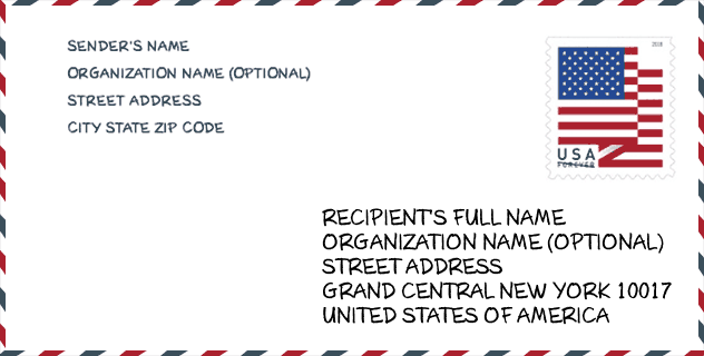
Envelop Voorbeeld

Dit is een voorbeeld van een Amerikaanse postenvelop. U kunt een 5-cijferige postcode of een gedetailleerde 9-cijferige postcode gebruiken om de mail in het volgende adresformaat te kopiëren.
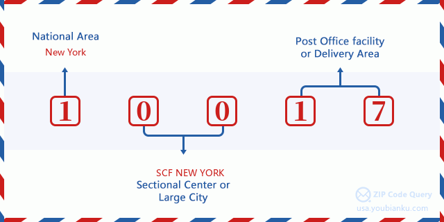
10017 Basisbetekenis
Waar staat elk cijfer van postcode 10017 voor? Het eerste cijfer geeft een nationaal gebied aan, dat varieert van nul voor het noordoosten tot negen voor het verre westen. De 2-3 cijfers zijn de code van een sectiecentrumfaciliteit in die regio. De laatste twee cijfers duiden kleine postkantoren of postzones aan.
Online landkaart

Het is een online kaart van adres Nyc, New York, United States. U kunt Knopje gebruiken te in/uitzoomen. De kaartinformatie is alleen ter referentie.
Universiteit

This is the ZIP Code 10017 - University page list. Its detail university Name, Street, City, State, ZIP Code, Phone is as below.
| Naam | Straat | Stad | Staat | Postcode | Telefoon |
| Berkeley College-New York | 3 East 43 Street | New York | NY | 10017 | (212) 986-4343 |
| CUNY System Office | 205 East 42nd Street | New York | NY | 10017 | - |
| Carsten Institute of Cosmetology | 290 Madison Avenue 5th Floor | New York | NY | 10017 | (212) 675-4884 |
Museum

Dit is de paginalijst van Postcode 10017 - Museum. Hieronder is het detail van Museum Naam, Straat, Stad, Staat, Postcode, Telefoon.
| Naam | Straat | Stad | Staat | Postcode | Telefoon |
| STONINGTON QUARRY MUSEUM | 147 EAST 48TH STREET | NEW YORK | NY | 10017 | (207) 367-5950 |
| GIRONA MUSEUM AND INSTITUTE | 501 LEXINGTON AVE | NYC | NY | 10017 | (212) 583-3181 |
| NEW YORK HISTORIC DISTRICTSPRESERVATION TRUST | 767 THIRD AVE | NEW YORK | NY | 10017 |
Bibliotheek

Dit is de paginalijst van Postcode 10017 - Bibliotheek. Hieronder is het detail van Bibliotheek Naam, Adres, Stad, Staat, Postcode, Telefoon.
- Naam: GRAND CENTRAL LIBRARY
- Adres: 135 EAST 46TH STREET
- Stad: NEW YORK
- Staat: NY - New York
- Postcode: 10017
- Telefoon: (212) 621-0670
Population for Postcode 10017

What is the total population in ZIP Code 10017? Below is detail information.
- Population for Postcode 10017: 18,328
- 2010 Bevolking: 16,575
The 2020 demographic statistics are in progress. The current population in ZIP code 10017 is 18,328, and the population in 2010 is 16,575.
Geslacht

In all the statistical population, the male population is 7,485, the female population is 9,090.
- Male Population: 7,485
- Female Population: 9,090
Race

In all the statistical population, the male population is 7,485, the female population is 9,090.
- White Population: 12,817
- Black Population: 641
- Hispanic Population: 1,078
- Asian Population: 3,200
- Hawaiian Population: 15
- Indian Population: 40
- Other Population: 267
Leeftijd

In all the statistical population, the White population is 12,817, the Black population is 641, the Hispanic population is 1,078, the Asian population is 3,200, the Hawaiian population is 15, the Indian Ppopulation is 40 and Other population is 267.
- Age's Median: 38.1
- Median of male age: 37.3
- Median of female age: 38.7
Households for Postcode 10017
ZIP code 10017 has 10,763 households, with an average number of 1.52 persons per household. The average income per household in Zip code 10017 is 127,506 USD, and the average house value is 637,300 USD.
- Households Per Zipcode: 10,763
- Personen per huishouden: 1.52
- Gemiddelde huiswaarde: 637,300
- Inkomen per huishouden: 127,506
Geographic

The latitude of the Zip code 10017 is 40.752516, the longitude is -73.973072, and the elevation is 39. It has land area of 0.317 square miles, and water area of 0 square miles. The time zone for ZIP code 10017 is Eastern (GMT -05:00). Daylight saving time should be observed in the area where the zip code is located.
- Breedtegraad: 40.752516
- Lengte: -73.973072
- Elevatie: 39
- Landoppervlak: 0.317
- Water Area: 0
- Tijd Zone: Eastern (GMT -05:00)
- Regio: Northeast
- Divisie: Middle Atlantic
- Zomertijd: Y
congresdistrict

The Congressional District for ZIP code 10017 is New York's 12th congressional district, the Congressional Land Area is 14.79 square mile.
- congresdistrict: 12th
- Congresgebied: 14.79
Levering

In the ZIP code 10017, there are 12,058 residential delivery mailboxes and centralized units, and 3,478 commercial delivery mailbox and centralized units, 50 single family deliveries and 12,008 multifamily deliveries, and the box count is 15,594. The main post office has city delivery carrier routes for the ZIP code 10017.
- Delivery Residential: 12,058
- Delivery Business: 3,478
- Delivery Total: 15,594
- Leveringseenheden voor één gezin: 50
- Multi Family Delivery Units: 12,008
- Stadsleveringsindicator: Y
Bedrijf

In ZIP code 10017, the number of business is 4,968, the number of employee is 143,474, the business first quarter payroll is 8,582,783,000 USD, the business annual payroll is 22,621,574,000 USD.
- Number Of Businesses: 4,968
- Number Of Employees: 143,474
- Zakelijke salarisadministratie eerste kwartaal: 8,582,783,000
- Zakelijke jaarlijkse loonlijst: 22,621,574,000
Sociale zekerheid

Er zijn 2,855 begunstigden met uitkeringen in de huidige betalingsstatus voor postcode 10017, waarvan 2,110 gepensioneerde werknemers, 155 gehandicapte werknemers, 100 weduwnaar (eren) en ouders, 135 zijn echtgenoten en 355 zijn kinderen. Het aantal begunstigden van 65 jaar of ouder is 2,375. De totale maandelijkse uitkeringen bedragen 5,189,000 USD, waarvan 4,276,000 USD voor gepensioneerde werknemers, 190,000 USD voor weduwnaar (eren) en ouders.
- Totaal aantal: 2,855
- Aantal gepensioneerden: 2,110
- Aantal gehandicapte werknemers: 155
- Weduwe / weduwnaar (er) en ouders Aantal: 100
- Echtgenoten nummer: 135
- Aantal kinderen: 355
- Alle begunstigden per maand: 5,189,000
- Gepensioneerde werknemers per maand: 4,276,000
- Weduwe (n) en ouders per maand: 190,000
- Aantal begunstigden van 65 jaar of ouder: 2,375


Reactie toevoegen