Verenigde Staten Postcode: 10033
Dit is de paginalijst van New York Postcode 10033. Hieronder is het detail van Staat, Graafschap, Stad, Lengte, Breedtegraad, Envelop Voorbeeld, Bevolking.

Postcode 10033 Informatie

-
-
Land:
U.S. - Verenigde Staten
Staat:
Staat FIPS:
36
Postcode:
10033
Postcode Type:
S (Standard)
❓Wat betekent S (Standard)? Een "standaard" postcode is waar de meeste mensen aan denken als ze het over postcodes hebben - in wezen een stad, een stad of een afdeling van een stad die een postdienst heeft.
Postcode 10033 - Stad

Dit is de stadsinformatie die overeenkomt met 10033:
| Staat | Graafschap | Stad | Stadtype ?In many cases, a ZIP Code can have multiple "names", meaning cities, towns, or subdivisions, in its boundaries. However, it will ALWAYS have exactly 1 "default" name. D - Default - This is the "preferred" name - by the USPS - for a city. Each ZIP Code has one - and only one - "default" name. In most cases, this is what people who live in that area call the city as well. A - Acceptable - This name can be used for mailing purposes. Often times alternative names are large neighborhoods or sections of the city/town. In some cases a ZIP Code may have several "acceptable" names which is used to group towns under one ZIP Code. N - Not Acceptable - A "not acceptable" name is, in many cases, a nickname that residents give that location. According to the USPS, you should NOT send mail to that ZIP Code using the "not acceptable" name when mailing. | Postcode |
|---|---|---|---|---|
| NY | New York | Manhattan | N (Not Acceptable) | 10033 |
| NY | New York | New York | D (Default) | 10033 |
| NY | New York | New York City | N (Not Acceptable) | 10033 |
| NY | New York | Ny | N (Not Acceptable) | 10033 |
| NY | New York | Ny City | N (Not Acceptable) | 10033 |
| NY | New York | Nyc | N (Not Acceptable) | 10033 |
| NY | New York | Washington Bridge | N (Not Acceptable) | 10033 |
❓Wat betekent D (Default)? Dit is de "geprefereerde" naam - door de USPS - voor een stad. Elke postcode heeft één - en slechts één - "standaard" naam. In de meeste gevallen noemen mensen die in dat gebied wonen de stad ook.
❓Wat betekent N (Not Acceptable)? Een "niet acceptabele" naam is in veel gevallen een bijnaam die bewoners aan die locatie geven. Volgens de USPS mag je GEEN post naar die postcode sturen met de "niet acceptabele" naam bij het mailen.
Postcode 10033 Plus 4
ZIP Code 5 plus 4 is de uitbreiding van de 5-cijferige postcode, het kan worden gebruikt om een meer gedetailleerde locatie te vinden. De laatste vier cijfers duiden een segment of een kant van een straat of een appartement aan. Hieronder vindt u de postcode en het bijbehorende adres van de postcode 10033.
| Postcode 5 Plus 4 | Adres |
|---|---|
| 10033-0001 | PO BOX 1, NEW YORK, NY |
| 10033-0061 | PO BOX 61, NEW YORK, NY |
| 10033-0121 | PO BOX 121, NEW YORK, NY |
| 10033-0181 | PO BOX 181, NEW YORK, NY |
| 10033-0241 | PO BOX 241, NEW YORK, NY |
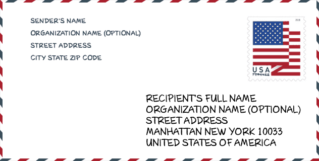
Envelop Voorbeeld

Dit is een voorbeeld van een Amerikaanse postenvelop. U kunt een 5-cijferige postcode of een gedetailleerde 9-cijferige postcode gebruiken om de mail in het volgende adresformaat te kopiëren.
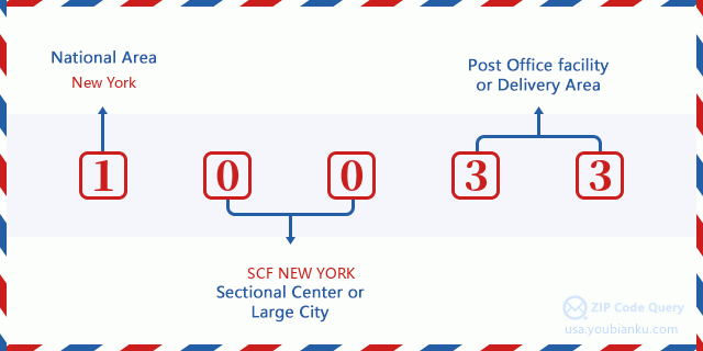
10033 Basisbetekenis
Waar staat elk cijfer van postcode 10033 voor? Het eerste cijfer geeft een nationaal gebied aan, dat varieert van nul voor het noordoosten tot negen voor het verre westen. De 2-3 cijfers zijn de code van een sectiecentrumfaciliteit in die regio. De laatste twee cijfers duiden kleine postkantoren of postzones aan.
Online landkaart

Het is een online kaart van adres Washington Bridge, New York, United States. U kunt Knopje gebruiken te in/uitzoomen. De kaartinformatie is alleen ter referentie.
Bibliotheek

Dit is de paginalijst van Postcode 10033 - Bibliotheek. Hieronder is het detail van Bibliotheek Naam, Adres, Stad, Staat, Postcode, Telefoon.
- Naam: FORT WASHINGTON BRANCH
- Adres: 535 WEST 179TH STREET
- Stad: NEW YORK
- Staat: NY - New York
- Postcode: 10033
- Telefoon: (212) 927-3533
School

Dit is de paginalijst van Postcode 10033 - School. Hieronder is het detail van School Naam, Adres, Stad, Staat, Postcode.
| School Naam | Adres | Stad | Staat | Klassen | Postcode |
|---|---|---|---|---|---|
| PS 48 PO MICHAEL J BUCZEK | 4360-78 BROADWAY | NEW YORK | NY | UG | 10033 |
| IS 528 BEA FULLER RODGERS SCHOOL | 180 WADSWORTH AVE | NEW YORK | NY | UG | 10033 |
| PS 115 ALEXANDER HUMBOLDT | 586 W 177TH ST | NEW YORK | NY | UG | 10033 |
| PS 132 JUAN PABLO DUARTE | 185 WADSWORTH AVE | NEW YORK | NY | UG | 10033 |
| JHS 143 ELEANOR ROOSEVELT | 511 W 182ND ST | NEW YORK | NY | UG | 10033 |
| PS 173 | 306 FT WASHINGTON AVE | NEW YORK | NY | UG | 10033 |
| HARBOR HEIGHTS | 306 FORT WASHINGTON AVE | NEW YORK | NY | UG | 10033 |
| COMMUNITY HEALTH ACADEMY OF THE HEIGHTS | 504 W 158TH ST | NEW YORK | NY | UG | 10033 |
| WASHINGTON HEIGHTS EXPEDITIONARY LEARNING SCHOOL | 511 W 182ND ST | NEW YORK | NY | UG | 10033 |
| DOS PUENTES ELEMENTARY SCHOOL | 185 WADSWORTH AVE | NEW YORK | NY | UG | 10033 |
| SCHOOL IN THE SQUARE PUBLIC CHARTER SCHOOL | 120 WADSWORTH AVE | NEW YORK | NY | UG | 10033 |
| ZETA CHARTER SCHOOL - INWOOD 1 | 652 W 187TH ST | NEW YORK | NY | UG | 10033 |
Population for Postcode 10033

What is the total population in ZIP Code 10033? Below is detail information.
- Population for Postcode 10033: 54,558
- 2010 Bevolking: 53,926
The 2020 demographic statistics are in progress. The current population in ZIP code 10033 is 54,558, and the population in 2010 is 53,926.
Geslacht

In all the statistical population, the male population is 26,461, the female population is 27,465.
- Male Population: 26,461
- Female Population: 27,465
Race

In all the statistical population, the male population is 26,461, the female population is 27,465.
- White Population: 25,533
- Black Population: 6,802
- Hispanic Population: 37,767
- Asian Population: 1,708
- Hawaiian Population: 263
- Indian Population: 1,290
- Other Population: 22,581
Leeftijd

In all the statistical population, the White population is 25,533, the Black population is 6,802, the Hispanic population is 37,767, the Asian population is 1,708, the Hawaiian population is 263, the Indian Ppopulation is 1,290 and Other population is 22,581.
- Age's Median: 35.2
- Median of male age: 32.8
- Median of female age: 37.9
Households for Postcode 10033
ZIP code 10033 has 18,975 households, with an average number of 2.80 persons per household. The average income per household in Zip code 10033 is 58,614 USD, and the average house value is 495,800 USD.
- Households Per Zipcode: 18,975
- Personen per huishouden: 2.80
- Gemiddelde huiswaarde: 495,800
- Inkomen per huishouden: 58,614
Geographic

The latitude of the Zip code 10033 is 40.858549, the longitude is -73.939550, and the elevation is 0. It has land area of 0.596 square miles, and water area of 0 square miles. The time zone for ZIP code 10033 is Eastern (GMT -05:00). Daylight saving time should be observed in the area where the zip code is located.
- Breedtegraad: 40.858549
- Lengte: -73.939550
- Elevatie: 0
- Landoppervlak: 0.596
- Water Area: 0
- Tijd Zone: Eastern (GMT -05:00)
- Regio: Northeast
- Divisie: Middle Atlantic
- Zomertijd: Y
congresdistrict

The Congressional District for ZIP code 10033 is New York's 13th congressional district, the Congressional Land Area is 10.25 square mile.
- congresdistrict: 13th
- Congresgebied: 10.25
Levering

In the ZIP code 10033, there are 19,485 residential delivery mailboxes and centralized units, and 984 commercial delivery mailbox and centralized units, 157 single family deliveries and 19,328 multifamily deliveries, and the box count is 21,012. The main post office has city delivery carrier routes for the ZIP code 10033.
- Delivery Residential: 19,485
- Delivery Business: 984
- Delivery Total: 21,012
- Leveringseenheden voor één gezin: 157
- Multi Family Delivery Units: 19,328
- Stadsleveringsindicator: Y
Bedrijf

In ZIP code 10033, the number of business is 1,000, the number of employee is 7,802, the business first quarter payroll is 67,204,000 USD, the business annual payroll is 280,287,000 USD.
- Number Of Businesses: 1,000
- Number Of Employees: 7,802
- Zakelijke salarisadministratie eerste kwartaal: 67,204,000
- Zakelijke jaarlijkse loonlijst: 280,287,000
Sociale zekerheid

Er zijn 8,990 begunstigden met uitkeringen in de huidige betalingsstatus voor postcode 10033, waarvan 6,400 gepensioneerde werknemers, 1,150 gehandicapte werknemers, 480 weduwnaar (eren) en ouders, 550 zijn echtgenoten en 410 zijn kinderen. Het aantal begunstigden van 65 jaar of ouder is 7,085. De totale maandelijkse uitkeringen bedragen 9,718,000 USD, waarvan 7,463,000 USD voor gepensioneerde werknemers, 496,000 USD voor weduwnaar (eren) en ouders.
- Totaal aantal: 8,990
- Aantal gepensioneerden: 6,400
- Aantal gehandicapte werknemers: 1,150
- Weduwe / weduwnaar (er) en ouders Aantal: 480
- Echtgenoten nummer: 550
- Aantal kinderen: 410
- Alle begunstigden per maand: 9,718,000
- Gepensioneerde werknemers per maand: 7,463,000
- Weduwe (n) en ouders per maand: 496,000
- Aantal begunstigden van 65 jaar of ouder: 7,085


Reactie toevoegen