Verenigde Staten Postcode: 17603
Dit is de paginalijst van Pennsylvania Postcode 17603. Hieronder is het detail van Staat, Graafschap, Stad, Lengte, Breedtegraad, Envelop Voorbeeld, Bevolking.
, showcasing historical and natural beauty with Wright’s Ferry Mansion, Robert Fulton Birthplace, autumn scenery, and Strasburg Rail Road train in a vintage airmail envelope, representing the unique features of ZIP Code 17603.")
Postcode 17603 Informatie

-
-
Land:
U.S. - Verenigde Staten
Staat:
Staat FIPS:
42
Postcode:
17603
Postcode Type:
S (Standard)
❓Wat betekent S (Standard)? Een "standaard" postcode is waar de meeste mensen aan denken als ze het over postcodes hebben - in wezen een stad, een stad of een afdeling van een stad die een postdienst heeft.
Postcode 17603 - Stad

Dit is de stadsinformatie die overeenkomt met 17603:
| Staat | Graafschap | Stad | Stadtype ?In many cases, a ZIP Code can have multiple "names", meaning cities, towns, or subdivisions, in its boundaries. However, it will ALWAYS have exactly 1 "default" name. D - Default - This is the "preferred" name - by the USPS - for a city. Each ZIP Code has one - and only one - "default" name. In most cases, this is what people who live in that area call the city as well. A - Acceptable - This name can be used for mailing purposes. Often times alternative names are large neighborhoods or sections of the city/town. In some cases a ZIP Code may have several "acceptable" names which is used to group towns under one ZIP Code. N - Not Acceptable - A "not acceptable" name is, in many cases, a nickname that residents give that location. According to the USPS, you should NOT send mail to that ZIP Code using the "not acceptable" name when mailing. | Postcode |
|---|---|---|---|---|
| PA | Lancaster | Lancaster | D (Default) | 17603 |
| PA | Lancaster | Leaf Park | N (Not Acceptable) | 17603 |
| PA | Lancaster | Manor Ridge | N (Not Acceptable) | 17603 |
| PA | Lancaster | New Danville | N (Not Acceptable) | 17603 |
| PA | Lancaster | Roherstown | N (Not Acceptable) | 17603 |
| PA | Lancaster | Rohrerstown | A (Acceptable) | 17603 |
| PA | Lancaster | West Lancaster | N (Not Acceptable) | 17603 |
❓Wat betekent D (Default)? Dit is de "geprefereerde" naam - door de USPS - voor een stad. Elke postcode heeft één - en slechts één - "standaard" naam. In de meeste gevallen noemen mensen die in dat gebied wonen de stad ook.
❓Wat betekent A (Acceptable)? Deze naam kan worden gebruikt voor mailingdoeleinden. Vaak zijn alternatieve namen grote buurten of delen van de stad / stad. In sommige gevallen kan een postcode meerdere "acceptabele" namen hebben die worden gebruikt om steden onder één postcode te groeperen.
❓Wat betekent N (Not Acceptable)? Een "niet acceptabele" naam is in veel gevallen een bijnaam die bewoners aan die locatie geven. Volgens de USPS mag je GEEN post naar die postcode sturen met de "niet acceptabele" naam bij het mailen.
Postcode 17603 Plus 4
ZIP Code 5 plus 4 is de uitbreiding van de 5-cijferige postcode, het kan worden gebruikt om een meer gedetailleerde locatie te vinden. De laatste vier cijfers duiden een segment of een kant van een straat of een appartement aan. Hieronder vindt u de postcode en het bijbehorende adres van de postcode 17603.
| Postcode 5 Plus 4 | Adres |
|---|---|
| 17603-1700 | 218 HARVARD AVE, LANCASTER, PA |
| 17603-1701 | 101 HARVARD AVE, LANCASTER, PA |
| 17603-1702 | 133 HARVARD AVE, LANCASTER, PA |
| 17603-1703 | 114 HARVARD AVE, LANCASTER, PA |
| 17603-1704 | 100 HARVARD AVE, LANCASTER, PA |
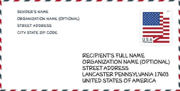
Envelop Voorbeeld

Dit is een voorbeeld van een Amerikaanse postenvelop. U kunt een 5-cijferige postcode of een gedetailleerde 9-cijferige postcode gebruiken om de mail in het volgende adresformaat te kopiëren.
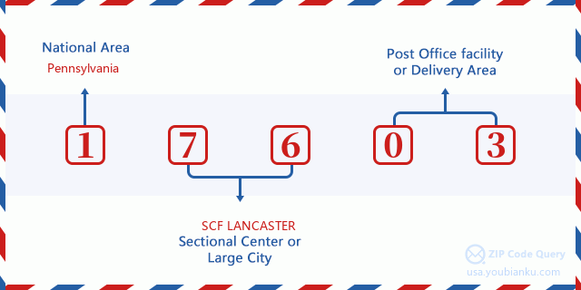
17603 Basisbetekenis
Waar staat elk cijfer van postcode 17603 voor? Het eerste cijfer geeft een nationaal gebied aan, dat varieert van nul voor het noordoosten tot negen voor het verre westen. De 2-3 cijfers zijn de code van een sectiecentrumfaciliteit in die regio. De laatste twee cijfers duiden kleine postkantoren of postzones aan.
Online landkaart

Het is een online kaart van adres West Lancaster, Pennsylvania, United States. U kunt Knopje gebruiken te in/uitzoomen. De kaartinformatie is alleen ter referentie.
Universiteit

This is the ZIP Code 17603 - University page list. Its detail university Name, Street, City, State, ZIP Code, Phone is as below.
| Naam | Straat | Stad | Staat | Postcode | Telefoon |
| Consolidated School of Business-Lancaster | 2124 Ambassador Cir | Lancaster | PA | 17603 | - |
| Empire Beauty School-Lancaster | 1801 Columbia Ave | Lancaster | PA | 17603 | (800) 920-4593 |
Ziekenhuis

Het is de Postcode 17603 - Ziekenhuis pagina lijst. Het detail Ziekenhuisnaam, straat, stad, staat, postcode, telefoon is zoals hieronder.
- Naam: LANCASTER BEHAVIORAL HEALTH HOSPITAL
- Adres: LANCASTER
- Stad: 333 HARRISBURG AVENUE
- Staat: PA
- Postcode: 17603
- Telefoon: (717) 740-4100
Museum

Dit is de paginalijst van Postcode 17603 - Museum. Hieronder is het detail van Museum Naam, Straat, Stad, Staat, Postcode, Telefoon.
| Naam | Straat | Stad | Staat | Postcode | Telefoon |
| WOLF MUSEUM OF MUSIC AND ART | 423 W CHESTNUT ST | LANCASTER | PA | 17603 | (717) 392-6382 |
| LANCASTER CULTURAL HISTORY MUSEUM | 7 W KING ST | LANCASTER | PA | 17603 | (717) 299-6440 |
| LANCASTER COUNTY HISTORICAL SOCIETY | 230 N PRESIDENT AVENUE | LANCASTER | PA | 17603 | (717) 392-4633 |
| NORTH MUSEUM OF NATURAL HISTORY AND SCIENCE | 400 COLLEGE AVENUE | LANCASTER | PA | 17603 | (717) 291-3941 |
School
Dit is de paginalijst van Postcode 17603 - School. Hieronder is het detail van School Naam, Adres, Stad, Staat, Postcode.
| School Naam | Adres | Stad | Staat | Klassen | Postcode |
|---|---|---|---|---|---|
| Lafayette El Sch | 1000 Fremont St | Lancaster | PA | UG | 17603 |
| Hambright El Sch | 3000 Charlestown Rd | Lancaster | PA | UG | 17603 |
Population for Postcode 17603

What is the total population in ZIP Code 17603? Below is detail information.
- Population for Postcode 17603: 64,956
- 2010 Bevolking: 61,973
The 2020 demographic statistics are in progress. The current population in ZIP code 17603 is 64,956, and the population in 2010 is 61,973.
Geslacht

In all the statistical population, the male population is 29,934, the female population is 32,039.
- Male Population: 29,934
- Female Population: 32,039
Race

In all the statistical population, the male population is 29,934, the female population is 32,039.
- White Population: 47,066
- Black Population: 7,573
- Hispanic Population: 14,386
- Asian Population: 1,955
- Hawaiian Population: 102
- Indian Population: 654
- Other Population: 7,261
Leeftijd

In all the statistical population, the White population is 47,066, the Black population is 7,573, the Hispanic population is 14,386, the Asian population is 1,955, the Hawaiian population is 102, the Indian Ppopulation is 654 and Other population is 7,261.
- Age's Median: 35.3
- Median of male age: 34.4
- Median of female age: 36.5
Households for Postcode 17603
ZIP code 17603 has 24,818 households, with an average number of 2.43 persons per household. The average income per household in Zip code 17603 is 52,917 USD, and the average house value is 155,400 USD.
- Households Per Zipcode: 24,818
- Personen per huishouden: 2.43
- Gemiddelde huiswaarde: 155,400
- Inkomen per huishouden: 52,917
Geographic

The latitude of the Zip code 17603 is 40.006626, the longitude is -76.360764, and the elevation is 397. It has land area of 29.807 square miles, and water area of 0.386 square miles. The time zone for ZIP code 17603 is Eastern (GMT -05:00). Daylight saving time should be observed in the area where the zip code is located.
- Breedtegraad: 40.006626
- Lengte: -76.360764
- Elevatie: 397
- Landoppervlak: 29.807
- Water Area: 0.386
- Tijd Zone: Eastern (GMT -05:00)
- Regio: Northeast
- Divisie: Middle Atlantic
- Zomertijd: Y
congresdistrict

The Congressional District for ZIP code 17603 is Pennsylvania's 11th congressional district, the Congressional Land Area is 3356.48 square mile.
- congresdistrict: 11th
- Congresgebied: 3356.48
Levering

In the ZIP code 17603, there are 26,731 residential delivery mailboxes and centralized units, and 1,735 commercial delivery mailbox and centralized units, 19,077 single family deliveries and 4,001 multifamily deliveries, and the box count is 32,001. The main post office has city delivery carrier routes for the ZIP code 17603.
- Delivery Residential: 26,731
- Delivery Business: 1,735
- Delivery Total: 32,001
- Leveringseenheden voor één gezin: 19,077
- Multi Family Delivery Units: 4,001
- Stadsleveringsindicator: Y
Bedrijf

In ZIP code 17603, the number of business is 1,492, the number of employee is 27,933, the business first quarter payroll is 324,123,000 USD, the business annual payroll is 1,232,469,000 USD.
- Number Of Businesses: 1,492
- Number Of Employees: 27,933
- Zakelijke salarisadministratie eerste kwartaal: 324,123,000
- Zakelijke jaarlijkse loonlijst: 1,232,469,000
Sociale zekerheid

Er zijn 13,160 begunstigden met uitkeringen in de huidige betalingsstatus voor postcode 17603, waarvan 8,705 gepensioneerde werknemers, 2,395 gehandicapte werknemers, 685 weduwnaar (eren) en ouders, 465 zijn echtgenoten en 910 zijn kinderen. Het aantal begunstigden van 65 jaar of ouder is 9,420. De totale maandelijkse uitkeringen bedragen 18,235,000 USD, waarvan 13,571,000 USD voor gepensioneerde werknemers, 967,000 USD voor weduwnaar (eren) en ouders.
- Totaal aantal: 13,160
- Aantal gepensioneerden: 8,705
- Aantal gehandicapte werknemers: 2,395
- Weduwe / weduwnaar (er) en ouders Aantal: 685
- Echtgenoten nummer: 465
- Aantal kinderen: 910
- Alle begunstigden per maand: 18,235,000
- Gepensioneerde werknemers per maand: 13,571,000
- Weduwe (n) en ouders per maand: 967,000
- Aantal begunstigden van 65 jaar of ouder: 9,420


Reactie toevoegen