Verenigde Staten Postcode: 17801
Dit is de paginalijst van Pennsylvania Postcode 17801. Hieronder is het detail van Staat, Graafschap, Stad, Lengte, Breedtegraad, Envelop Voorbeeld, Bevolking.

Postcode 17801 Informatie

-
-
Land:
U.S. - Verenigde Staten
Staat:
Staat FIPS:
42
Postcode:
17801
Postcode Type:
S (Standard)
❓Wat betekent S (Standard)? Een "standaard" postcode is waar de meeste mensen aan denken als ze het over postcodes hebben - in wezen een stad, een stad of een afdeling van een stad die een postdienst heeft.
Postcode 17801 - Stad

Dit is de stadsinformatie die overeenkomt met 17801:
| Staat | Graafschap | Stad | Stadtype ?In many cases, a ZIP Code can have multiple "names", meaning cities, towns, or subdivisions, in its boundaries. However, it will ALWAYS have exactly 1 "default" name. D - Default - This is the "preferred" name - by the USPS - for a city. Each ZIP Code has one - and only one - "default" name. In most cases, this is what people who live in that area call the city as well. A - Acceptable - This name can be used for mailing purposes. Often times alternative names are large neighborhoods or sections of the city/town. In some cases a ZIP Code may have several "acceptable" names which is used to group towns under one ZIP Code. N - Not Acceptable - A "not acceptable" name is, in many cases, a nickname that residents give that location. According to the USPS, you should NOT send mail to that ZIP Code using the "not acceptable" name when mailing. | Postcode |
|---|---|---|---|---|
| PA | Northumberland | Augustaville | N (Not Acceptable) | 17801 |
| PA | Northumberland | Fishers Ferry | N (Not Acceptable) | 17801 |
| PA | Northumberland | Island Park | N (Not Acceptable) | 17801 |
| PA | Northumberland | Klines Grove | N (Not Acceptable) | 17801 |
| PA | Northumberland | Lower Augusta | N (Not Acceptable) | 17801 |
| PA | Northumberland | Mile Hill | N (Not Acceptable) | 17801 |
| PA | Northumberland | Mile Run | N (Not Acceptable) | 17801 |
| PA | Northumberland | Oaklyn | N (Not Acceptable) | 17801 |
| PA | Northumberland | Rockefeller | N (Not Acceptable) | 17801 |
| PA | Northumberland | Sevenpoints | N (Not Acceptable) | 17801 |
| PA | Northumberland | Stonington | N (Not Acceptable) | 17801 |
| PA | Northumberland | Sunbury | D (Default) | 17801 |
| PA | Northumberland | Upper Augusta | N (Not Acceptable) | 17801 |
❓Wat betekent D (Default)? Dit is de "geprefereerde" naam - door de USPS - voor een stad. Elke postcode heeft één - en slechts één - "standaard" naam. In de meeste gevallen noemen mensen die in dat gebied wonen de stad ook.
❓Wat betekent N (Not Acceptable)? Een "niet acceptabele" naam is in veel gevallen een bijnaam die bewoners aan die locatie geven. Volgens de USPS mag je GEEN post naar die postcode sturen met de "niet acceptabele" naam bij het mailen.
Postcode 17801 Plus 4
ZIP Code 5 plus 4 is de uitbreiding van de 5-cijferige postcode, het kan worden gebruikt om een meer gedetailleerde locatie te vinden. De laatste vier cijfers duiden een segment of een kant van een straat of een appartement aan. Hieronder vindt u de postcode en het bijbehorende adres van de postcode 17801.
| Postcode 5 Plus 4 | Adres |
|---|---|
| 17801-0001 | PO BOX 1, SUNBURY, PA |
| 17801-0033 | PO BOX 33, SUNBURY, PA |
| 17801-0034 | PO BOX 34, SUNBURY, PA |
| 17801-0050 | PO BOX 50, SUNBURY, PA |
| 17801-0051 | PO BOX 51, SUNBURY, PA |
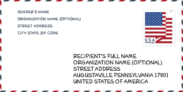
Envelop Voorbeeld

Dit is een voorbeeld van een Amerikaanse postenvelop. U kunt een 5-cijferige postcode of een gedetailleerde 9-cijferige postcode gebruiken om de mail in het volgende adresformaat te kopiëren.
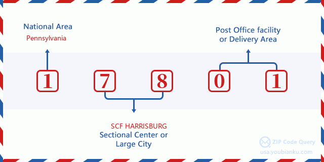
17801 Basisbetekenis
Waar staat elk cijfer van postcode 17801 voor? Het eerste cijfer geeft een nationaal gebied aan, dat varieert van nul voor het noordoosten tot negen voor het verre westen. De 2-3 cijfers zijn de code van een sectiecentrumfaciliteit in die regio. De laatste twee cijfers duiden kleine postkantoren of postzones aan.
Online landkaart

Het is een online kaart van adres Upper Augusta, Pennsylvania, United States. U kunt Knopje gebruiken te in/uitzoomen. De kaartinformatie is alleen ter referentie.
Universiteit

This is the ZIP Code 17801 - University page list. Its detail university Name, Street, City, State, ZIP Code, Phone is as below.
| Naam | Straat | Stad | Staat | Postcode | Telefoon |
| Triangle Tech Inc-Sunbury | 191 Performance Road | Sunbury | PA | 17801 | (570) 988-0700 |
Ziekenhuis

Het is de Postcode 17801 - Ziekenhuis pagina lijst. Het detail Ziekenhuisnaam, straat, stad, staat, postcode, telefoon is zoals hieronder.
- Naam: SUNBURY COMMUNITY HOSPITAL
- Adres: SUNBURY
- Stad: 350 NORTH 11TH STREET
- Staat: PA
- Postcode: 17801
- Telefoon: (570) 286-3333
Bibliotheek

Dit is de paginalijst van Postcode 17801 - Bibliotheek. Hieronder is het detail van Bibliotheek Naam, Adres, Stad, Staat, Postcode, Telefoon.
- Naam: DEGENSTEIN COMMUNITY LIBRARY
- Adres: 40 SOUTH FIFTH STREET
- Stad: SUNBURY
- Staat: PA - Pennsylvania
- Postcode: 17801
- Telefoon: (570) 286-2461
School
Dit is de paginalijst van Postcode 17801 - School. Hieronder is het detail van School Naam, Adres, Stad, Staat, Postcode.
| School Naam | Adres | Stad | Staat | Klassen | Postcode |
|---|---|---|---|---|---|
| Chief Shikellamy Sch | 338 Memorial Drive | Sunbury | PA | UG | 17801 |
| Oaklyn Sch | 115 Oak Street | Sunbury | PA | UG | 17801 |
| Shikellamy HS | 600 Walnut Street | Sunbury | PA | UG | 17801 |
Population for Postcode 17801

What is the total population in ZIP Code 17801? Below is detail information.
- Population for Postcode 17801: 16,728
- 2010 Bevolking: 16,671
The 2020 demographic statistics are in progress. The current population in ZIP code 17801 is 16,728, and the population in 2010 is 16,671.
Geslacht

In all the statistical population, the male population is 8,124, the female population is 8,547.
- Male Population: 8,124
- Female Population: 8,547
Race

In all the statistical population, the male population is 8,124, the female population is 8,547.
- White Population: 15,927
- Black Population: 441
- Hispanic Population: 747
- Asian Population: 56
- Hawaiian Population: 9
- Indian Population: 127
- Other Population: 380
Leeftijd

In all the statistical population, the White population is 15,927, the Black population is 441, the Hispanic population is 747, the Asian population is 56, the Hawaiian population is 9, the Indian Ppopulation is 127 and Other population is 380.
- Age's Median: 42.2
- Median of male age: 40.9
- Median of female age: 43.5
Households for Postcode 17801
ZIP code 17801 has 6,949 households, with an average number of 2.34 persons per household. The average income per household in Zip code 17801 is 44,867 USD, and the average house value is 122,500 USD.
- Households Per Zipcode: 6,949
- Personen per huishouden: 2.34
- Gemiddelde huiswaarde: 122,500
- Inkomen per huishouden: 44,867
Geographic

The latitude of the Zip code 17801 is 40.832999, the longitude is -76.774688, and the elevation is 739. It has land area of 65.982 square miles, and water area of 5.603 square miles. The time zone for ZIP code 17801 is Eastern (GMT -05:00). Daylight saving time should be observed in the area where the zip code is located.
- Breedtegraad: 40.832999
- Lengte: -76.774688
- Elevatie: 739
- Landoppervlak: 65.982
- Water Area: 5.603
- Tijd Zone: Eastern (GMT -05:00)
- Regio: Northeast
- Divisie: Middle Atlantic
- Zomertijd: Y
congresdistrict

The Congressional District for ZIP code 17801 is Pennsylvania's 12th congressional district, the Congressional Land Area is 2163.03 square mile.
- congresdistrict: 12th
- Congresgebied: 2163.03
Levering

In the ZIP code 17801, there are 7,149 residential delivery mailboxes and centralized units, and 427 commercial delivery mailbox and centralized units, 6,557 single family deliveries and 517 multifamily deliveries, and the box count is 7,824. The main post office has city delivery carrier routes for the ZIP code 17801.
- Delivery Residential: 7,149
- Delivery Business: 427
- Delivery Total: 7,824
- Leveringseenheden voor één gezin: 6,557
- Multi Family Delivery Units: 517
- Stadsleveringsindicator: Y
Bedrijf

In ZIP code 17801, the number of business is 348, the number of employee is 4,780, the business first quarter payroll is 49,614,000 USD, the business annual payroll is 198,956,000 USD.
- Number Of Businesses: 348
- Number Of Employees: 4,780
- Zakelijke salarisadministratie eerste kwartaal: 49,614,000
- Zakelijke jaarlijkse loonlijst: 198,956,000
Sociale zekerheid

Er zijn 4,450 begunstigden met uitkeringen in de huidige betalingsstatus voor postcode 17801, waarvan 2,870 gepensioneerde werknemers, 785 gehandicapte werknemers, 260 weduwnaar (eren) en ouders, 125 zijn echtgenoten en 410 zijn kinderen. Het aantal begunstigden van 65 jaar of ouder is 3,055. De totale maandelijkse uitkeringen bedragen 5,583,000 USD, waarvan 4,009,000 USD voor gepensioneerde werknemers, 337,000 USD voor weduwnaar (eren) en ouders.
- Totaal aantal: 4,450
- Aantal gepensioneerden: 2,870
- Aantal gehandicapte werknemers: 785
- Weduwe / weduwnaar (er) en ouders Aantal: 260
- Echtgenoten nummer: 125
- Aantal kinderen: 410
- Alle begunstigden per maand: 5,583,000
- Gepensioneerde werknemers per maand: 4,009,000
- Weduwe (n) en ouders per maand: 337,000
- Aantal begunstigden van 65 jaar of ouder: 3,055


Reactie toevoegen