Verenigde Staten Postcode: 20132
Dit is de paginalijst van Virginia Postcode 20132. Hieronder is het detail van Staat, Graafschap, Stad, Lengte, Breedtegraad, Envelop Voorbeeld, Bevolking.
Postcode 20132 Informatie

-
-
Land:
U.S. - Verenigde Staten
Staat:
Staat FIPS:
51
Netnummer:
Postcode:
20132
Postcode Type:
S (Standard)
❓Wat betekent S (Standard)? Een "standaard" postcode is waar de meeste mensen aan denken als ze het over postcodes hebben - in wezen een stad, een stad of een afdeling van een stad die een postdienst heeft.
Postcode 20132 - Stad

Dit is de stadsinformatie die overeenkomt met 20132:
| Staat | Graafschap | Stad | Stadtype ?In many cases, a ZIP Code can have multiple "names", meaning cities, towns, or subdivisions, in its boundaries. However, it will ALWAYS have exactly 1 "default" name. D - Default - This is the "preferred" name - by the USPS - for a city. Each ZIP Code has one - and only one - "default" name. In most cases, this is what people who live in that area call the city as well. A - Acceptable - This name can be used for mailing purposes. Often times alternative names are large neighborhoods or sections of the city/town. In some cases a ZIP Code may have several "acceptable" names which is used to group towns under one ZIP Code. N - Not Acceptable - A "not acceptable" name is, in many cases, a nickname that residents give that location. According to the USPS, you should NOT send mail to that ZIP Code using the "not acceptable" name when mailing. | Postcode |
|---|---|---|---|---|
| VA | Loudoun | Hillsboro | A (Acceptable) | 20132 |
| VA | Loudoun | Purcellville | D (Default) | 20132 |
❓Wat betekent D (Default)? Dit is de "geprefereerde" naam - door de USPS - voor een stad. Elke postcode heeft één - en slechts één - "standaard" naam. In de meeste gevallen noemen mensen die in dat gebied wonen de stad ook.
❓Wat betekent A (Acceptable)? Deze naam kan worden gebruikt voor mailingdoeleinden. Vaak zijn alternatieve namen grote buurten of delen van de stad / stad. In sommige gevallen kan een postcode meerdere "acceptabele" namen hebben die worden gebruikt om steden onder één postcode te groeperen.
Postcode 20132 Plus 4
ZIP Code 5 plus 4 is de uitbreiding van de 5-cijferige postcode, het kan worden gebruikt om een meer gedetailleerde locatie te vinden. De laatste vier cijfers duiden een segment of een kant van een straat of een appartement aan. Hieronder vindt u de postcode en het bijbehorende adres van de postcode 20132.
| Postcode 5 Plus 4 | Adres |
|---|---|
| 20132-1700 | 36500 KIDWELL RD, PURCELLVILLE, VA |
| 20132-1701 | 36501 KIDWELL RD, HILLSBORO, VA |
| 20132-1702 | 35900 CHARLES TOWN PIKE, PURCELLVILLE, VA |
| 20132-1703 | 35901 CHARLES TOWN PIKE, HILLSBORO, VA |
| 20132-1704 | 35800 CHARLES TOWN PIKE, PURCELLVILLE, VA |
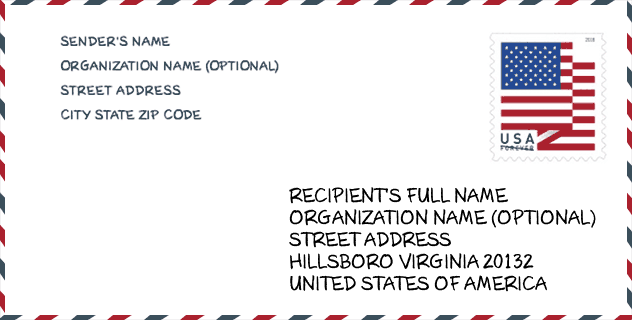
Envelop Voorbeeld

Dit is een voorbeeld van een Amerikaanse postenvelop. U kunt een 5-cijferige postcode of een gedetailleerde 9-cijferige postcode gebruiken om de mail in het volgende adresformaat te kopiëren.
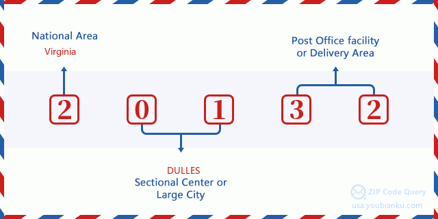
20132 Basisbetekenis
Waar staat elk cijfer van postcode 20132 voor? Het eerste cijfer geeft een nationaal gebied aan, dat varieert van nul voor het noordoosten tot negen voor het verre westen. De 2-3 cijfers zijn de code van een sectiecentrumfaciliteit in die regio. De laatste twee cijfers duiden kleine postkantoren of postzones aan.
Online landkaart

Het is een online kaart van adres Purcellville, Virginia, United States. U kunt Knopje gebruiken te in/uitzoomen. De kaartinformatie is alleen ter referentie.
Universiteit

This is the ZIP Code 20132 - University page list. Its detail university Name, Street, City, State, ZIP Code, Phone is as below.
| Naam | Straat | Stad | Staat | Postcode | Telefoon |
| Patrick Henry College | 10 Patrick Henry Circle | Purcellville | VA | 20132 | (540) 338-1776 |
Bibliotheek

Dit is de paginalijst van Postcode 20132 - Bibliotheek. Hieronder is het detail van Bibliotheek Naam, Adres, Stad, Staat, Postcode, Telefoon.
- Naam: PURCELLVILLE LIBRARY
- Adres: 220 EAST MAIN STREET
- Stad: PURCELLVILLE
- Staat: VA - Virginia
- Postcode: 20132
- Telefoon: (540) 338-7235
School
Dit is de paginalijst van Postcode 20132 - School. Hieronder is het detail van School Naam, Adres, Stad, Staat, Postcode.
| School Naam | Adres | Stad | Staat | Klassen | Postcode |
|---|---|---|---|---|---|
| BLUE RIDGE MIDDLE | 551 East A St | Purcellville | VA | UG | 20132 |
| EMERICK ELEM | 440 S Nursery Ave | Purcellville | VA | UG | 20132 |
| LINCOLN ELEM | 18048 Lincoln Rd | Purcellville | VA | UG | 20132 |
| LOUDOUN VALLEY HIGH | 340 N Maple Ave | Purcellville | VA | UG | 20132 |
| WOODGROVE HIGH | 36811 Allder School Road | Purcellville | VA | UG | 20132 |
| HILLSBORO CHARTER ACADEMY | 37110 Charles Town Pike | Purcellville | VA | UG | 20132 |
Population for Postcode 20132

What is the total population in ZIP Code 20132? Below is detail information.
- Population for Postcode 20132: 18,005
- 2010 Bevolking: 15,900
The 2020 demographic statistics are in progress. The current population in ZIP code 20132 is 18,005, and the population in 2010 is 15,900.
Geslacht

In all the statistical population, the male population is 7,836, the female population is 8,064.
- Male Population: 7,836
- Female Population: 8,064
Race

In all the statistical population, the male population is 7,836, the female population is 8,064.
- White Population: 14,627
- Black Population: 770
- Hispanic Population: 794
- Asian Population: 584
- Hawaiian Population: 28
- Indian Population: 129
- Other Population: 259
Leeftijd

In all the statistical population, the White population is 14,627, the Black population is 770, the Hispanic population is 794, the Asian population is 584, the Hawaiian population is 28, the Indian Ppopulation is 129 and Other population is 259.
- Age's Median: 38.8
- Median of male age: 38.0
- Median of female age: 39.3
Households for Postcode 20132
ZIP code 20132 has 5,154 households, with an average number of 3.04 persons per household. The average income per household in Zip code 20132 is 138,687 USD, and the average house value is 511,100 USD.
- Households Per Zipcode: 5,154
- Personen per huishouden: 3.04
- Gemiddelde huiswaarde: 511,100
- Inkomen per huishouden: 138,687
Housing Unit

In ZIP code 20132, the growth rank of housing unit is 18, the number of housing unit was 312,311 in 2010 and increased to 325,405 in 2011, the growth increase number is 13,094, the growth increase percentage is 4.2%.
- Growth Rank: 18
- Housing Units Estimate in 2010: 312,311
- Housing Units Estimate in 2011: 325,405
- Growth Increase Number: 13,094
- Growth Increase Percentage: 4.2%
Geographic

The latitude of the Zip code 20132 is 39.173958, the longitude is -77.732530, and the elevation is 614. It has land area of 82.912 square miles, and water area of 0.748 square miles. The time zone for ZIP code 20132 is Eastern (GMT -05:00). Daylight saving time should be observed in the area where the zip code is located.
- Breedtegraad: 39.173958
- Lengte: -77.732530
- Elevatie: 614
- Landoppervlak: 82.912
- Water Area: 0.748
- Tijd Zone: Eastern (GMT -05:00)
- Regio: South
- Divisie: South Atlantic
- Zomertijd: Y
congresdistrict

The Congressional District for ZIP code 20132 is Virginia's 10th congressional district, the Congressional Land Area is 1372.24 square mile.
- congresdistrict: 10th
- Congresgebied: 1372.24
Levering

In the ZIP code 20132, there are 5,923 residential delivery mailboxes and centralized units, and 397 commercial delivery mailbox and centralized units, 4,990 single family deliveries and 0 multifamily deliveries, and the box count is 6,122. The main post office does not have city delivery carrier routes for the ZIP code 20132.
- Delivery Residential: 5,923
- Delivery Business: 397
- Delivery Total: 6,122
- Leveringseenheden voor één gezin: 4,990
- Multi Family Delivery Units: 0
- Stadsleveringsindicator: N
Bedrijf

In ZIP code 20132, the number of business is 540, the number of employee is 6,021, the business first quarter payroll is 65,577,000 USD, the business annual payroll is 269,680,000 USD.
- Number Of Businesses: 540
- Number Of Employees: 6,021
- Zakelijke salarisadministratie eerste kwartaal: 65,577,000
- Zakelijke jaarlijkse loonlijst: 269,680,000
Sociale zekerheid

Er zijn 1,925 begunstigden met uitkeringen in de huidige betalingsstatus voor postcode 20132, waarvan 1,500 gepensioneerde werknemers, 95 gehandicapte werknemers, 110 weduwnaar (eren) en ouders, 90 zijn echtgenoten en 130 zijn kinderen. Het aantal begunstigden van 65 jaar of ouder is 1,615. De totale maandelijkse uitkeringen bedragen 3,242,000 USD, waarvan 2,692,000 USD voor gepensioneerde werknemers, 185,000 USD voor weduwnaar (eren) en ouders.
- Totaal aantal: 1,925
- Aantal gepensioneerden: 1,500
- Aantal gehandicapte werknemers: 95
- Weduwe / weduwnaar (er) en ouders Aantal: 110
- Echtgenoten nummer: 90
- Aantal kinderen: 130
- Alle begunstigden per maand: 3,242,000
- Gepensioneerde werknemers per maand: 2,692,000
- Weduwe (n) en ouders per maand: 185,000
- Aantal begunstigden van 65 jaar of ouder: 1,615


Reactie toevoegen