Postcode: 25701, Huntington, WV
Postcode 25701 bevindt zich in Huntington, West Virginia. Het detail staat, provincie, stad, lengtegraad, breedtegraad, envelop Voorbeeld, Bevolking is zoals hieronder.
Postcode 25701 Informatie

-
-
Land:
U.S. - Verenigde Staten
Staat:
Regio FIPS:
54011
Graafschap:
Stad:
Stadtype ?In many cases, a ZIP Code can have multiple "names", meaning cities, towns, or subdivisions, in its boundaries. However, it will ALWAYS have exactly 1 "default" name. D - Default - This is the "preferred" name - by the USPS - for a city. Each ZIP Code has one - and only one - "default" name. In most cases, this is what people who live in that area call the city as well. A - Acceptable - This name can be used for mailing purposes. Often times alternative names are large neighborhoods or sections of the city/town. In some cases a ZIP Code may have several "acceptable" names which is used to group towns under one ZIP Code. N - Not Acceptable - A "not acceptable" name is, in many cases, a nickname that residents give that location. According to the USPS, you should NOT send mail to that ZIP Code using the "not acceptable" name when mailing.:
D (Default)
Postcode:
25701
❓Wat betekent D (Default)? Dit is de "geprefereerde" naam - door de USPS - voor een stad. Elke postcode heeft één - en slechts één - "standaard" naam. In de meeste gevallen noemen mensen die in dat gebied wonen de stad ook.
Postcode 25701 Plus 4
ZIP Code 5 plus 4 is de uitbreiding van de 5-cijferige postcode, het kan worden gebruikt om een meer gedetailleerde locatie te vinden. De laatste vier cijfers duiden een segment of een kant van een straat of een appartement aan. Hieronder vindt u de postcode en het bijbehorende adres van de postcode 25701.
| Postcode 5 Plus 4 | Adres |
|---|---|
| 25701-0195 | 1340 HAL GREER BLVD, HUNTINGTON, WV |
| 25701-1000 | 547 ADAMS AVE, HUNTINGTON, WV |
| 25701-1001 | 501 VIRGINIA AVE, HUNTINGTON, WV |
| 25701-1002 | 500 VIRGINIA AVE, HUNTINGTON, WV |
| 25701-1003 | 601 VIRGINIA AVE, HUNTINGTON, WV |
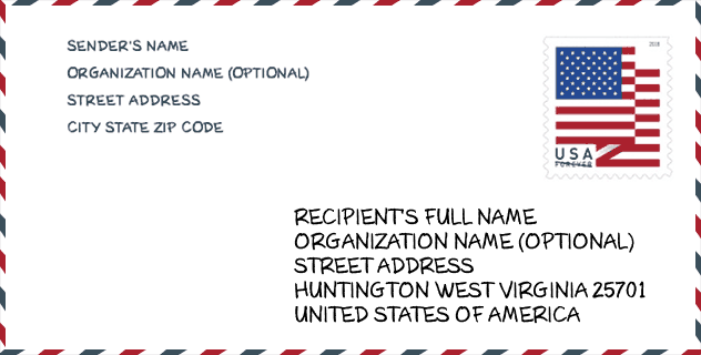
Envelop Voorbeeld

Dit is een voorbeeld van een Amerikaanse postenvelop. U kunt een 5-cijferige postcode of een gedetailleerde 9-cijferige postcode gebruiken om de mail in het volgende adresformaat te kopiëren.
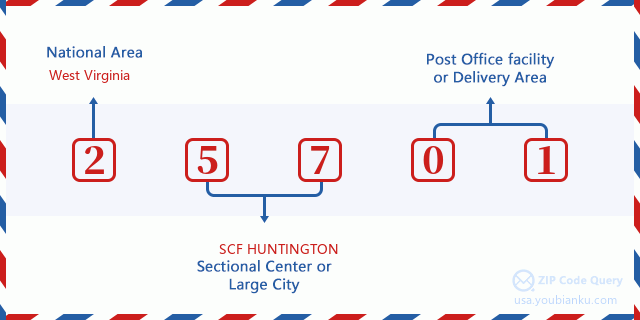
25701 Basisbetekenis
Waar staat elk cijfer van postcode 25701 voor? Het eerste cijfer geeft een nationaal gebied aan, dat varieert van nul voor het noordoosten tot negen voor het verre westen. De 2-3 cijfers zijn de code van een sectiecentrumfaciliteit in die regio. De laatste twee cijfers duiden kleine postkantoren of postzones aan.
Online landkaart

Het is een online kaart van adres Huntington, West Virginia, United States. U kunt Knopje gebruiken te in/uitzoomen. De kaartinformatie is alleen ter referentie.
Universiteit

This is the ZIP Code 25701 - University page list. Its detail university Name, Street, City, State, ZIP Code, Phone is as below.
| Naam | Straat | Stad | Staat | Postcode | Telefoon |
| Huntington Junior College | 900 Fifth Ave | Huntington | WV | 25701 | (304) 697-7550 |
| Mountwest Community and Technical College | One Mountwest Way | Huntington | WV | 25701 | (866) 710-3140 |
Ziekenhuis

Het is de Postcode 25701 - Ziekenhuis pagina lijst. Het detail Ziekenhuisnaam, straat, stad, staat, postcode, telefoon is zoals hieronder.
| Naam | Adres | Stad | Staat | Postcode | Telefoon |
|---|---|---|---|---|---|
| CABELL HUNTINGTON HOSPITAL INC | 1340 HAL GREER BOULEVARD | HUNTINGTON | WV | 25701 | (304) 526-2192 |
| RIVER PARK HOSPITAL | 1230 SIXTH AVENUE | HUNTINGTON | WV | 25701 | (304) 526-9100 |
Bibliotheek

Dit is de paginalijst van Postcode 25701 - Bibliotheek. Hieronder is het detail van Bibliotheek Naam, Adres, Stad, Staat, Postcode, Telefoon.
- Naam: CABELL COUNTY PUBLIC LIBRARY
- Adres: 455 9TH STREET
- Stad: HUNTINGTON
- Staat: WV - West Virginia
- Postcode: 25701
- Telefoon: (304) 528-5700
School
Dit is de paginalijst van Postcode 25701 - School. Hieronder is het detail van School Naam, Adres, Stad, Staat, Postcode.
| School Naam | Adres | Stad | Staat | Klassen | Postcode |
|---|---|---|---|---|---|
| HITE SAUNDERS ELEMENTARY SCHOOL | 3708 GREEN VALLEY ROAD | HUNTINGTON | WV | UG | 25701 |
| MEADOWS ELEMENTARY SCHOOL | 1601 WASHINGTON BLVD | HUNTINGTON | WV | UG | 25701 |
| HUNTINGTON HIGH SCHOOL | 1 HIGHLANDER WAY | HUNTINGTON | WV | UG | 25701 |
| SPRING HILL ELEMENTARY SCHOOL | 1901 HALL AVENUE | HUNTINGTON | WV | UG | 25701 |
| HUNTINGTON MIDDLE SCHOOL | 925 THIRD STREET | HUNTINGTON | WV | UG | 25701 |
| SOUTHSIDE ELEMENTARY | 930 SECOND STREET | HUNTINGTON | WV | UG | 25701 |
| CAMMACK CHILDREN?S CENTER | 64 WEST 6TH AVENUE | HUNTINGTON | WV | UG | 25701 |
Population for Postcode 25701

What is the total population in ZIP Code 25701? Below is detail information.
- Population for Postcode 25701: 23,144
- 2010 Bevolking: 23,284
The 2020 demographic statistics are in progress. The current population in ZIP code 25701 is 23,144, and the population in 2010 is 23,284.
Geslacht

In all the statistical population, the male population is 11,513, the female population is 11,771.
- Male Population: 11,513
- Female Population: 11,771
Race

In all the statistical population, the male population is 11,513, the female population is 11,771.
- White Population: 20,480
- Black Population: 2,625
- Hispanic Population: 287
- Asian Population: 426
- Hawaiian Population: 23
- Indian Population: 234
- Other Population: 104
Leeftijd

In all the statistical population, the White population is 20,480, the Black population is 2,625, the Hispanic population is 287, the Asian population is 426, the Hawaiian population is 23, the Indian Ppopulation is 234 and Other population is 104.
- Age's Median: 39.3
- Median of male age: 36.7
- Median of female age: 42.1
Households for Postcode 25701
ZIP code 25701 has 10,911 households, with an average number of 2.06 persons per household. The average income per household in Zip code 25701 is 36,022 USD, and the average house value is 122,400 USD.
- Households Per Zipcode: 10,911
- Personen per huishouden: 2.06
- Gemiddelde huiswaarde: 122,400
- Inkomen per huishouden: 36,022
Geographic

The latitude of the Zip code 25701 is 38.368924, the longitude is -82.412756, and the elevation is 727. It has land area of 35.541 square miles, and water area of 0.358 square miles. The time zone for ZIP code 25701 is Eastern (GMT -05:00). Daylight saving time should be observed in the area where the zip code is located.
- Breedtegraad: 38.368924
- Lengte: -82.412756
- Elevatie: 727
- Landoppervlak: 35.541
- Water Area: 0.358
- Tijd Zone: Eastern (GMT -05:00)
- Regio: South
- Divisie: South Atlantic
- Zomertijd: Y
congresdistrict

The Congressional District for ZIP code 25701 is West Virginia's 3rd congressional district, the Congressional Land Area is 9745.33 square mile.
- congresdistrict: 3rd
- Congresgebied: 9745.33
Levering

In the ZIP code 25701, there are 11,235 residential delivery mailboxes and centralized units, and 1,133 commercial delivery mailbox and centralized units, 8,753 single family deliveries and 2,349 multifamily deliveries, and the box count is 12,327. The main post office has city delivery carrier routes for the ZIP code 25701.
- Delivery Residential: 11,235
- Delivery Business: 1,133
- Delivery Total: 12,327
- Leveringseenheden voor één gezin: 8,753
- Multi Family Delivery Units: 2,349
- Stadsleveringsindicator: Y
Bedrijf

In ZIP code 25701, the number of business is 869, the number of employee is 18,417, the business first quarter payroll is 184,124,000 USD, the business annual payroll is 760,648,000 USD.
- Number Of Businesses: 869
- Number Of Employees: 18,417
- Zakelijke salarisadministratie eerste kwartaal: 184,124,000
- Zakelijke jaarlijkse loonlijst: 760,648,000
Sociale zekerheid

Er zijn 5,170 begunstigden met uitkeringen in de huidige betalingsstatus voor postcode 25701, waarvan 3,310 gepensioneerde werknemers, 890 gehandicapte werknemers, 385 weduwnaar (eren) en ouders, 185 zijn echtgenoten en 400 zijn kinderen. Het aantal begunstigden van 65 jaar of ouder is 3,710. De totale maandelijkse uitkeringen bedragen 6,925,000 USD, waarvan 4,985,000 USD voor gepensioneerde werknemers, 515,000 USD voor weduwnaar (eren) en ouders.
- Totaal aantal: 5,170
- Aantal gepensioneerden: 3,310
- Aantal gehandicapte werknemers: 890
- Weduwe / weduwnaar (er) en ouders Aantal: 385
- Echtgenoten nummer: 185
- Aantal kinderen: 400
- Alle begunstigden per maand: 6,925,000
- Gepensioneerde werknemers per maand: 4,985,000
- Weduwe (n) en ouders per maand: 515,000
- Aantal begunstigden van 65 jaar of ouder: 3,710


Reactie toevoegen