Verenigde Staten Postcode: 43701
Dit is de paginalijst van Ohio Postcode 43701. Hieronder is het detail van Staat, Graafschap, Stad, Lengte, Breedtegraad, Envelop Voorbeeld, Bevolking.

Postcode 43701 Informatie

-
-
Land:
U.S. - Verenigde Staten
Staat:
Staat FIPS:
39
Postcode:
43701
Postcode Type:
S (Standard)
❓Wat betekent S (Standard)? Een "standaard" postcode is waar de meeste mensen aan denken als ze het over postcodes hebben - in wezen een stad, een stad of een afdeling van een stad die een postdienst heeft.
Postcode 43701 - Stad

Dit is de stadsinformatie die overeenkomt met 43701:
| Staat | Graafschap | Stad | Stadtype ?In many cases, a ZIP Code can have multiple "names", meaning cities, towns, or subdivisions, in its boundaries. However, it will ALWAYS have exactly 1 "default" name. D - Default - This is the "preferred" name - by the USPS - for a city. Each ZIP Code has one - and only one - "default" name. In most cases, this is what people who live in that area call the city as well. A - Acceptable - This name can be used for mailing purposes. Often times alternative names are large neighborhoods or sections of the city/town. In some cases a ZIP Code may have several "acceptable" names which is used to group towns under one ZIP Code. N - Not Acceptable - A "not acceptable" name is, in many cases, a nickname that residents give that location. According to the USPS, you should NOT send mail to that ZIP Code using the "not acceptable" name when mailing. | Postcode |
|---|---|---|---|---|
| OH | Muskingum | S Zanesville | A (Acceptable) | 43701 |
| OH | Muskingum | Sonora | A (Acceptable) | 43701 |
| OH | Muskingum | South Zanesville | A (Acceptable) | 43701 |
| OH | Muskingum | Zanesville | D (Default) | 43701 |
❓Wat betekent D (Default)? Dit is de "geprefereerde" naam - door de USPS - voor een stad. Elke postcode heeft één - en slechts één - "standaard" naam. In de meeste gevallen noemen mensen die in dat gebied wonen de stad ook.
❓Wat betekent A (Acceptable)? Deze naam kan worden gebruikt voor mailingdoeleinden. Vaak zijn alternatieve namen grote buurten of delen van de stad / stad. In sommige gevallen kan een postcode meerdere "acceptabele" namen hebben die worden gebruikt om steden onder één postcode te groeperen.
Postcode 43701 Plus 4
ZIP Code 5 plus 4 is de uitbreiding van de 5-cijferige postcode, het kan worden gebruikt om een meer gedetailleerde locatie te vinden. De laatste vier cijfers duiden een segment of een kant van een straat of een appartement aan. Hieronder vindt u de postcode en het bijbehorende adres van de postcode 43701.
| Postcode 5 Plus 4 | Adres |
|---|---|
| 43701-0001 | 1204 BRANDYWINE BLVD #A , ZANESVILLE, OH |
| 43701-0200 | 2 HOGANS DR, ZANESVILLE, OH |
| 43701-0201 | 100 HOGANS DR, ZANESVILLE, OH |
| 43701-0202 | 101 HOGANS DR, ZANESVILLE, OH |
| 43701-0203 | 1 HOGANS DR, ZANESVILLE, OH |
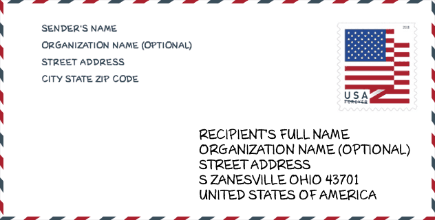
Envelop Voorbeeld

Dit is een voorbeeld van een Amerikaanse postenvelop. U kunt een 5-cijferige postcode of een gedetailleerde 9-cijferige postcode gebruiken om de mail in het volgende adresformaat te kopiëren.
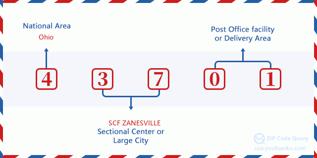
43701 Basisbetekenis
Waar staat elk cijfer van postcode 43701 voor? Het eerste cijfer geeft een nationaal gebied aan, dat varieert van nul voor het noordoosten tot negen voor het verre westen. De 2-3 cijfers zijn de code van een sectiecentrumfaciliteit in die regio. De laatste twee cijfers duiden kleine postkantoren of postzones aan.
Online landkaart

Het is een online kaart van adres Zanesville, Ohio, United States. U kunt Knopje gebruiken te in/uitzoomen. De kaartinformatie is alleen ter referentie.
Universiteit

This is the ZIP Code 43701 - University page list. Its detail university Name, Street, City, State, ZIP Code, Phone is as below.
| Naam | Straat | Stad | Staat | Postcode | Telefoon |
| Mid-EastCTC-Adult Education | 400 Richards Rd | Zanesville | OH | 43701 | (740) 455-3111 |
| Ohio University-Zanesville Campus | 1425 Newark Rd | Zanesville | OH | 43701 | (740) 453-0762 |
| Valley Beauty School | 627 Main St | Zanesville | OH | 43701 | - |
Ziekenhuis

Het is de Postcode 43701 - Ziekenhuis pagina lijst. Het detail Ziekenhuisnaam, straat, stad, staat, postcode, telefoon is zoals hieronder.
- Naam: GENESIS HOSPITAL
- Adres: ZANESVILLE
- Stad: 2951 MAPLE AVENUE
- Staat: OH
- Postcode: 43701
- Telefoon: (740) 454-5000
Bibliotheek

Dit is de paginalijst van Postcode 43701 - Bibliotheek. Hieronder is het detail van Bibliotheek Naam, Adres, Stad, Staat, Postcode, Telefoon.
| Naam | Adres | Stad | Staat | Postcode | Telefoon |
|---|---|---|---|---|---|
| MUSKINGUM COUNTY LIBRARY SYSTEM | 220 N. FIFTH ST. | ZANESVILLE | OH | 43701 | (740) 453-0391 |
| SOUTH BRANCH | 2530 MAYSVILLE PIKE | ZANESVILLE | OH | 43701 | (740) 454-1511 |
School
Dit is de paginalijst van Postcode 43701 - School. Hieronder is het detail van School Naam, Adres, Stad, Staat, Postcode.
- School Naam: Maysville High School
- Adres: 3725 Panther Drive
- Stad: Zanesville
- Staat: OH
- Klassen: UG
- Postcode: 43701
Population for Postcode 43701

What is the total population in ZIP Code 43701? Below is detail information.
- Population for Postcode 43701: 56,965
- 2010 Bevolking: 55,643
The 2020 demographic statistics are in progress. The current population in ZIP code 43701 is 56,965, and the population in 2010 is 55,643.
Geslacht

In all the statistical population, the male population is 26,544, the female population is 29,099.
- Male Population: 26,544
- Female Population: 29,099
Race

In all the statistical population, the male population is 26,544, the female population is 29,099.
- White Population: 51,991
- Black Population: 4,332
- Hispanic Population: 492
- Asian Population: 338
- Hawaiian Population: 36
- Indian Population: 615
- Other Population: 253
Leeftijd

In all the statistical population, the White population is 51,991, the Black population is 4,332, the Hispanic population is 492, the Asian population is 338, the Hawaiian population is 36, the Indian Ppopulation is 615 and Other population is 253.
- Age's Median: 40.3
- Median of male age: 38.5
- Median of female age: 42.0
Households for Postcode 43701
ZIP code 43701 has 23,019 households, with an average number of 2.38 persons per household. The average income per household in Zip code 43701 is 41,898 USD, and the average house value is 111,300 USD.
- Households Per Zipcode: 23,019
- Personen per huishouden: 2.38
- Gemiddelde huiswaarde: 111,300
- Inkomen per huishouden: 41,898
Geographic

The latitude of the Zip code 43701 is 39.962926, the longitude is -81.988471, and the elevation is 825. It has land area of 180.427 square miles, and water area of 2.817 square miles. The time zone for ZIP code 43701 is Eastern (GMT -05:00). Daylight saving time should be observed in the area where the zip code is located.
- Breedtegraad: 39.962926
- Lengte: -81.988471
- Elevatie: 825
- Landoppervlak: 180.427
- Water Area: 2.817
- Tijd Zone: Eastern (GMT -05:00)
- Regio: Midwest
- Divisie: East North Central
- Zomertijd: Y
congresdistrict

The Congressional District for ZIP code 43701 is Ohio's 06th|12th congressional district, the Congressional Land Area is 7215.03|2271.91 square mile.
- congresdistrict: 06th|12th
- Congresgebied: 7215.03|2271.91
Levering

In the ZIP code 43701, there are 23,935 residential delivery mailboxes and centralized units, and 1,846 commercial delivery mailbox and centralized units, 20,339 single family deliveries and 918 multifamily deliveries, and the box count is 25,689. The main post office has city delivery carrier routes for the ZIP code 43701.
- Delivery Residential: 23,935
- Delivery Business: 1,846
- Delivery Total: 25,689
- Leveringseenheden voor één gezin: 20,339
- Multi Family Delivery Units: 918
- Stadsleveringsindicator: Y
Bedrijf

In ZIP code 43701, the number of business is 1,349, the number of employee is 25,884, the business first quarter payroll is 251,957,000 USD, the business annual payroll is 1,078,088,000 USD.
- Number Of Businesses: 1,349
- Number Of Employees: 25,884
- Zakelijke salarisadministratie eerste kwartaal: 251,957,000
- Zakelijke jaarlijkse loonlijst: 1,078,088,000
Sociale zekerheid

Er zijn 13,570 begunstigden met uitkeringen in de huidige betalingsstatus voor postcode 43701, waarvan 8,625 gepensioneerde werknemers, 2,500 gehandicapte werknemers, 1,060 weduwnaar (eren) en ouders, 410 zijn echtgenoten en 975 zijn kinderen. Het aantal begunstigden van 65 jaar of ouder is 9,440. De totale maandelijkse uitkeringen bedragen 16,881,000 USD, waarvan 11,817,000 USD voor gepensioneerde werknemers, 1,345,000 USD voor weduwnaar (eren) en ouders.
- Totaal aantal: 13,570
- Aantal gepensioneerden: 8,625
- Aantal gehandicapte werknemers: 2,500
- Weduwe / weduwnaar (er) en ouders Aantal: 1,060
- Echtgenoten nummer: 410
- Aantal kinderen: 975
- Alle begunstigden per maand: 16,881,000
- Gepensioneerde werknemers per maand: 11,817,000
- Weduwe (n) en ouders per maand: 1,345,000
- Aantal begunstigden van 65 jaar of ouder: 9,440


Reactie toevoegen