Verenigde Staten Postcode: 46074
Dit is de paginalijst van Indiana Postcode 46074. Hieronder is het detail van Staat, Graafschap, Stad, Lengte, Breedtegraad, Envelop Voorbeeld, Bevolking.

Postcode 46074 Informatie

-
-
Land:
U.S. - Verenigde Staten
Staat:
Staat FIPS:
18
Postcode:
46074
Postcode Type:
S (Standard)
❓Wat betekent S (Standard)? Een "standaard" postcode is waar de meeste mensen aan denken als ze het over postcodes hebben - in wezen een stad, een stad of een afdeling van een stad die een postdienst heeft.
Postcode 46074 - Stad

Dit is de stadsinformatie die overeenkomt met 46074:
| Staat | Graafschap | Stad | Stadtype ?In many cases, a ZIP Code can have multiple "names", meaning cities, towns, or subdivisions, in its boundaries. However, it will ALWAYS have exactly 1 "default" name. D - Default - This is the "preferred" name - by the USPS - for a city. Each ZIP Code has one - and only one - "default" name. In most cases, this is what people who live in that area call the city as well. A - Acceptable - This name can be used for mailing purposes. Often times alternative names are large neighborhoods or sections of the city/town. In some cases a ZIP Code may have several "acceptable" names which is used to group towns under one ZIP Code. N - Not Acceptable - A "not acceptable" name is, in many cases, a nickname that residents give that location. According to the USPS, you should NOT send mail to that ZIP Code using the "not acceptable" name when mailing. | Postcode |
|---|---|---|---|---|
| IN | Hamilton | Carmel | A (Acceptable) | 46074 |
| IN | Hamilton | Westfield | D (Default) | 46074 |
❓Wat betekent D (Default)? Dit is de "geprefereerde" naam - door de USPS - voor een stad. Elke postcode heeft één - en slechts één - "standaard" naam. In de meeste gevallen noemen mensen die in dat gebied wonen de stad ook.
❓Wat betekent A (Acceptable)? Deze naam kan worden gebruikt voor mailingdoeleinden. Vaak zijn alternatieve namen grote buurten of delen van de stad / stad. In sommige gevallen kan een postcode meerdere "acceptabele" namen hebben die worden gebruikt om steden onder één postcode te groeperen.
Postcode 46074 Plus 4
ZIP Code 5 plus 4 is de uitbreiding van de 5-cijferige postcode, het kan worden gebruikt om een meer gedetailleerde locatie te vinden. De laatste vier cijfers duiden een segment of een kant van een straat of een appartement aan. Hieronder vindt u de postcode en het bijbehorende adres van de postcode 46074.
| Postcode 5 Plus 4 | Adres |
|---|---|
| 46074-0001 | PO BOX 1, WESTFIELD, IN |
| 46074-0040 | 3100 FERRELL DR, CARMEL, IN |
| 46074-0041 | PO BOX 41, WESTFIELD, IN |
| 46074-0049 | 3200 FERRELL DR, CARMEL, IN |
| 46074-0050 | 2500 MURPHY CIR, CARMEL, IN |
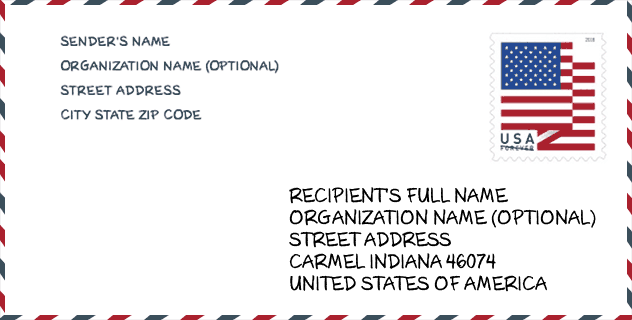
Envelop Voorbeeld

Dit is een voorbeeld van een Amerikaanse postenvelop. U kunt een 5-cijferige postcode of een gedetailleerde 9-cijferige postcode gebruiken om de mail in het volgende adresformaat te kopiëren.
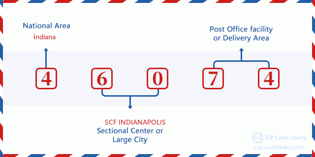
46074 Basisbetekenis
Waar staat elk cijfer van postcode 46074 voor? Het eerste cijfer geeft een nationaal gebied aan, dat varieert van nul voor het noordoosten tot negen voor het verre westen. De 2-3 cijfers zijn de code van een sectiecentrumfaciliteit in die regio. De laatste twee cijfers duiden kleine postkantoren of postzones aan.
Online landkaart

Het is een online kaart van adres Westfield, Indiana, United States. U kunt Knopje gebruiken te in/uitzoomen. De kaartinformatie is alleen ter referentie.
Bibliotheek

Dit is de paginalijst van Postcode 46074 - Bibliotheek. Hieronder is het detail van Bibliotheek Naam, Adres, Stad, Staat, Postcode, Telefoon.
- Naam: WESTFIELD-WASHINGTON PUBLIC LIBRARY
- Adres: 333 WEST HOOVER STREET
- Stad: WESTFIELD
- Staat: IN - Indiana
- Postcode: 46074
- Telefoon: (317) 896-9391
School

Dit is de paginalijst van Postcode 46074 - School. Hieronder is het detail van School Naam, Adres, Stad, Staat, Postcode.
| School Naam | Adres | Stad | Staat | Klassen | Postcode |
|---|---|---|---|---|---|
| Shamrock Springs Elementary School | 747 W 161st St | Westfield | IN | UG | 46074 |
| Westfield Intermediate School | 326 W Main St | Westfield | IN | UG | 46074 |
| Carey Ridge Elementary School | 16231 Carey Rd | Westfield | IN | UG | 46074 |
| Oak Trace Elementary School | 16504 Oak Ridge Rd | Westfield | IN | UG | 46074 |
| Washington Woods Elementary School | 17950 Grassy Branch Rd | Westfield | IN | UG | 46074 |
| Westfield Middle School | 345 W Hoover St | Westfield | IN | UG | 46074 |
| Westfield High School | 18250 N Union St | Westfield | IN | UG | 46074 |
| Maple Glen Elementary | 17171 Ditch Rd | Westfield | IN | UG | 46074 |
| Monon Trail Elementary School | 19400 Tomlinson Rd | Westfield | IN | UG | 46074 |
Population for Postcode 46074

What is the total population in ZIP Code 46074? Below is detail information.
- Population for Postcode 46074: 44,905
- 2010 Bevolking: 26,745
The 2020 demographic statistics are in progress. The current population in ZIP code 46074 is 44,905, and the population in 2010 is 26,745.
Geslacht

In all the statistical population, the male population is 13,117, the female population is 13,628.
- Male Population: 13,117
- Female Population: 13,628
Race

In all the statistical population, the male population is 13,117, the female population is 13,628.
- White Population: 23,250
- Black Population: 921
- Hispanic Population: 1,551
- Asian Population: 2,148
- Hawaiian Population: 21
- Indian Population: 163
- Other Population: 770
Leeftijd

In all the statistical population, the White population is 23,250, the Black population is 921, the Hispanic population is 1,551, the Asian population is 2,148, the Hawaiian population is 21, the Indian Ppopulation is 163 and Other population is 770.
- Age's Median: 33.5
- Median of male age: 32.7
- Median of female age: 34.2
Households for Postcode 46074
ZIP code 46074 has 9,064 households, with an average number of 2.93 persons per household. The average income per household in Zip code 46074 is 98,643 USD, and the average house value is 263,300 USD.
- Households Per Zipcode: 9,064
- Personen per huishouden: 2.93
- Gemiddelde huiswaarde: 263,300
- Inkomen per huishouden: 98,643
Housing Unit

In ZIP code 46074, the growth rank of housing unit is 64, the number of housing unit was 274,569 in 2010 and increased to 282,810 in 2011, the growth increase number is 8,241, the growth increase percentage is 3.0%.
- Growth Rank: 64
- Housing Units Estimate in 2010: 274,569
- Housing Units Estimate in 2011: 282,810
- Growth Increase Number: 8,241
- Growth Increase Percentage: 3.0%
Geographic

The latitude of the Zip code 46074 is 40.037328, the longitude is -86.165878, and the elevation is 918. It has land area of 36.109 square miles, and water area of 0.153 square miles. The time zone for ZIP code 46074 is Eastern (GMT -05:00). Daylight saving time should be observed in the area where the zip code is located.
- Breedtegraad: 40.037328
- Lengte: -86.165878
- Elevatie: 918
- Landoppervlak: 36.109
- Water Area: 0.153
- Tijd Zone: Eastern (GMT -05:00)
- Regio: Midwest
- Divisie: East North Central
- Zomertijd: Y
congresdistrict

The Congressional District for ZIP code 46074 is Indiana's 05th congressional district, the Congressional Land Area is 1924.76 square mile.
- congresdistrict: 05th
- Congresgebied: 1924.76
Levering

In the ZIP code 46074, there are 15,326 residential delivery mailboxes and centralized units, and 552 commercial delivery mailbox and centralized units, 12,975 single family deliveries and 346 multifamily deliveries, and the box count is 16,525. The main post office does not have city delivery carrier routes for the ZIP code 46074.
- Delivery Residential: 15,326
- Delivery Business: 552
- Delivery Total: 16,525
- Leveringseenheden voor één gezin: 12,975
- Multi Family Delivery Units: 346
- Stadsleveringsindicator: N
Bedrijf

In ZIP code 46074, the number of business is 669, the number of employee is 9,804, the business first quarter payroll is 117,807,000 USD, the business annual payroll is 489,551,000 USD.
- Number Of Businesses: 669
- Number Of Employees: 9,804
- Zakelijke salarisadministratie eerste kwartaal: 117,807,000
- Zakelijke jaarlijkse loonlijst: 489,551,000
Sociale zekerheid

Er zijn 4,375 begunstigden met uitkeringen in de huidige betalingsstatus voor postcode 46074, waarvan 3,265 gepensioneerde werknemers, 370 gehandicapte werknemers, 285 weduwnaar (eren) en ouders, 200 zijn echtgenoten en 255 zijn kinderen. Het aantal begunstigden van 65 jaar of ouder is 3,550. De totale maandelijkse uitkeringen bedragen 7,138,000 USD, waarvan 5,717,000 USD voor gepensioneerde werknemers, 479,000 USD voor weduwnaar (eren) en ouders.
- Totaal aantal: 4,375
- Aantal gepensioneerden: 3,265
- Aantal gehandicapte werknemers: 370
- Weduwe / weduwnaar (er) en ouders Aantal: 285
- Echtgenoten nummer: 200
- Aantal kinderen: 255
- Alle begunstigden per maand: 7,138,000
- Gepensioneerde werknemers per maand: 5,717,000
- Weduwe (n) en ouders per maand: 479,000
- Aantal begunstigden van 65 jaar of ouder: 3,550


Reactie toevoegen