Verenigde Staten Postcode: 46241
Dit is de paginalijst van Indiana Postcode 46241. Hieronder is het detail van Staat, Graafschap, Stad, Lengte, Breedtegraad, Envelop Voorbeeld, Bevolking.

Postcode 46241 Informatie

-
-
Land:
U.S. - Verenigde Staten
Staat:
Staat FIPS:
18
Netnummer:
Postcode:
46241
Postcode Type:
S (Standard)
❓Wat betekent S (Standard)? Een "standaard" postcode is waar de meeste mensen aan denken als ze het over postcodes hebben - in wezen een stad, een stad of een afdeling van een stad die een postdienst heeft.
Postcode 46241 - Stad

Dit is de stadsinformatie die overeenkomt met 46241:
| Staat | Graafschap | Stad | Stadtype ?In many cases, a ZIP Code can have multiple "names", meaning cities, towns, or subdivisions, in its boundaries. However, it will ALWAYS have exactly 1 "default" name. D - Default - This is the "preferred" name - by the USPS - for a city. Each ZIP Code has one - and only one - "default" name. In most cases, this is what people who live in that area call the city as well. A - Acceptable - This name can be used for mailing purposes. Often times alternative names are large neighborhoods or sections of the city/town. In some cases a ZIP Code may have several "acceptable" names which is used to group towns under one ZIP Code. N - Not Acceptable - A "not acceptable" name is, in many cases, a nickname that residents give that location. According to the USPS, you should NOT send mail to that ZIP Code using the "not acceptable" name when mailing. | Postcode |
|---|---|---|---|---|
| IN | Marion | Drexel Gardens | N (Not Acceptable) | 46241 |
| IN | Marion | Drexel Gdns | N (Not Acceptable) | 46241 |
| IN | Marion | Indianapolis | D (Default) | 46241 |
| IN | Marion | Mars Hill | N (Not Acceptable) | 46241 |
| IN | Marion | Maywood | N (Not Acceptable) | 46241 |
❓Wat betekent D (Default)? Dit is de "geprefereerde" naam - door de USPS - voor een stad. Elke postcode heeft één - en slechts één - "standaard" naam. In de meeste gevallen noemen mensen die in dat gebied wonen de stad ook.
❓Wat betekent N (Not Acceptable)? Een "niet acceptabele" naam is in veel gevallen een bijnaam die bewoners aan die locatie geven. Volgens de USPS mag je GEEN post naar die postcode sturen met de "niet acceptabele" naam bij het mailen.
Postcode 46241 Plus 4
ZIP Code 5 plus 4 is de uitbreiding van de 5-cijferige postcode, het kan worden gebruikt om een meer gedetailleerde locatie te vinden. De laatste vier cijfers duiden een segment of een kant van een straat of een appartement aan. Hieronder vindt u de postcode en het bijbehorende adres van de postcode 46241.
| Postcode 5 Plus 4 | Adres |
|---|---|
| 46241-0500 | 432 S MICKLEY AVE, INDIANAPOLIS, IN |
| 46241-0502 | 500 S WHITCOMB AVE, INDIANAPOLIS, IN |
| 46241-0503 | 401 ARMENTROUT LN, INDIANAPOLIS, IN |
| 46241-0504 | 400 ARMENTROUT LN, INDIANAPOLIS, IN |
| 46241-0505 | 501 ARMENTROUT LN, INDIANAPOLIS, IN |
Envelop Voorbeeld

Dit is een voorbeeld van een Amerikaanse postenvelop. U kunt een 5-cijferige postcode of een gedetailleerde 9-cijferige postcode gebruiken om de mail in het volgende adresformaat te kopiëren.

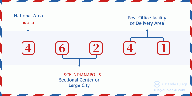
46241 Basisbetekenis
Waar staat elk cijfer van postcode 46241 voor? Het eerste cijfer geeft een nationaal gebied aan, dat varieert van nul voor het noordoosten tot negen voor het verre westen. De 2-3 cijfers zijn de code van een sectiecentrumfaciliteit in die regio. De laatste twee cijfers duiden kleine postkantoren of postzones aan.
Online landkaart

Het is een online kaart van adres Maywood, Indiana, United States. U kunt Knopje gebruiken te in/uitzoomen. De kaartinformatie is alleen ter referentie.
Universiteit

This is the ZIP Code 46241 - University page list. Its detail university Name, Street, City, State, ZIP Code, Phone is as below.
| Naam | Straat | Stad | Staat | Postcode | Telefoon |
| Aviation Institute of Maintenance-Indianapolis | 7251 W. McCarty St. | Indianapolis | IN | 46241 | (317) 243-4519 |
| MyComputerCareer.com | 2601 Fortune Circle Dr E, Suite 100C | Indianapolis | IN | 46241 | (919) 813-6266 |
| Purdue University-Purdue Polytechnic Indianapolis | 2175 South Hoffman Road | Indianapolis | IN | 46241 | (317) 484-1824 |
School
Dit is de paginalijst van Postcode 46241 - School. Hieronder is het detail van School Naam, Adres, Stad, Staat, Postcode.
| School Naam | Adres | Stad | Staat | Klassen | Postcode |
|---|---|---|---|---|---|
| Damar Charter Academy | 5125 Decatur Blvd Ste D | Indianapolis | IN | UG | 46241 |
| Liberty Early Elementary School | 4640 Santa Fe Dr | Indianapolis | IN | UG | 46241 |
| Maplewood Elementary School | 1643 Dunlap Ave | Indianapolis | IN | UG | 46241 |
| McClelland Elementary School | 6740 W Morris | Indianapolis | IN | UG | 46241 |
| Rhoades Elementary School | 502 S Auburn St | Indianapolis | IN | UG | 46241 |
| Lynhurst 7th & 8th Grade Center | 2805 S Lynhurst | Indianapolis | IN | UG | 46241 |
| Stout Field Elementary School | 3820 W Bradbury | Indianapolis | IN | UG | 46241 |
| Ben Davis University High School | 1155 S High School Rd | Indianapolis | IN | UG | 46241 |
Population for Postcode 46241

What is the total population in ZIP Code 46241? Below is detail information.
- Population for Postcode 46241: 32,780
- 2010 Bevolking: 30,670
The 2020 demographic statistics are in progress. The current population in ZIP code 46241 is 32,780, and the population in 2010 is 30,670.
Geslacht

In all the statistical population, the male population is 15,190, the female population is 15,480.
- Male Population: 15,190
- Female Population: 15,480
Race

In all the statistical population, the male population is 15,190, the female population is 15,480.
- White Population: 25,157
- Black Population: 3,677
- Hispanic Population: 3,291
- Asian Population: 281
- Hawaiian Population: 42
- Indian Population: 331
- Other Population: 2,098
Leeftijd

In all the statistical population, the White population is 25,157, the Black population is 3,677, the Hispanic population is 3,291, the Asian population is 281, the Hawaiian population is 42, the Indian Ppopulation is 331 and Other population is 2,098.
- Age's Median: 32.4
- Median of male age: 31.7
- Median of female age: 33.1
Households for Postcode 46241
ZIP code 46241 has 11,267 households, with an average number of 2.70 persons per household. The average income per household in Zip code 46241 is 38,102 USD, and the average house value is 76,200 USD.
- Households Per Zipcode: 11,267
- Personen per huishouden: 2.70
- Gemiddelde huiswaarde: 76,200
- Inkomen per huishouden: 38,102
Geographic

The latitude of the Zip code 46241 is 39.716911, the longitude is -86.261552, and the elevation is 755. It has land area of 22.328 square miles, and water area of 0.095 square miles. The time zone for ZIP code 46241 is Eastern (GMT -05:00). Daylight saving time should be observed in the area where the zip code is located.
- Breedtegraad: 39.716911
- Lengte: -86.261552
- Elevatie: 755
- Landoppervlak: 22.328
- Water Area: 0.095
- Tijd Zone: Eastern (GMT -05:00)
- Regio: Midwest
- Divisie: East North Central
- Zomertijd: Y
congresdistrict

The Congressional District for ZIP code 46241 is Indiana's 07th congressional district, the Congressional Land Area is 303.84 square mile.
- congresdistrict: 07th
- Congresgebied: 303.84
Levering

In the ZIP code 46241, there are 12,141 residential delivery mailboxes and centralized units, and 1,311 commercial delivery mailbox and centralized units, 8,937 single family deliveries and 219 multifamily deliveries, and the box count is 15,197. The main post office has city delivery carrier routes for the ZIP code 46241.
- Delivery Residential: 12,141
- Delivery Business: 1,311
- Delivery Total: 15,197
- Leveringseenheden voor één gezin: 8,937
- Multi Family Delivery Units: 219
- Stadsleveringsindicator: Y
Bedrijf

In ZIP code 46241, the number of business is 1,016, the number of employee is 40,910, the business first quarter payroll is 541,088,000 USD, the business annual payroll is 2,120,167,000 USD.
- Number Of Businesses: 1,016
- Number Of Employees: 40,910
- Zakelijke salarisadministratie eerste kwartaal: 541,088,000
- Zakelijke jaarlijkse loonlijst: 2,120,167,000
Sociale zekerheid

Er zijn 5,325 begunstigden met uitkeringen in de huidige betalingsstatus voor postcode 46241, waarvan 2,795 gepensioneerde werknemers, 1,425 gehandicapte werknemers, 350 weduwnaar (eren) en ouders, 105 zijn echtgenoten en 650 zijn kinderen. Het aantal begunstigden van 65 jaar of ouder is 2,940. De totale maandelijkse uitkeringen bedragen 6,624,000 USD, waarvan 4,018,000 USD voor gepensioneerde werknemers, 473,000 USD voor weduwnaar (eren) en ouders.
- Totaal aantal: 5,325
- Aantal gepensioneerden: 2,795
- Aantal gehandicapte werknemers: 1,425
- Weduwe / weduwnaar (er) en ouders Aantal: 350
- Echtgenoten nummer: 105
- Aantal kinderen: 650
- Alle begunstigden per maand: 6,624,000
- Gepensioneerde werknemers per maand: 4,018,000
- Weduwe (n) en ouders per maand: 473,000
- Aantal begunstigden van 65 jaar of ouder: 2,940


Reactie toevoegen