Postcode: 49007, Kalamazoo, MI
Postcode 49007 bevindt zich in Kalamazoo, Michigan. Het detail staat, provincie, stad, lengtegraad, breedtegraad, envelop Voorbeeld, Bevolking is zoals hieronder.
Postcode 49007 Informatie

-
-
Land:
U.S. - Verenigde Staten
Staat:
Regio FIPS:
26077
Graafschap:
Stad:
Netnummer:
Stadtype ?In many cases, a ZIP Code can have multiple "names", meaning cities, towns, or subdivisions, in its boundaries. However, it will ALWAYS have exactly 1 "default" name. D - Default - This is the "preferred" name - by the USPS - for a city. Each ZIP Code has one - and only one - "default" name. In most cases, this is what people who live in that area call the city as well. A - Acceptable - This name can be used for mailing purposes. Often times alternative names are large neighborhoods or sections of the city/town. In some cases a ZIP Code may have several "acceptable" names which is used to group towns under one ZIP Code. N - Not Acceptable - A "not acceptable" name is, in many cases, a nickname that residents give that location. According to the USPS, you should NOT send mail to that ZIP Code using the "not acceptable" name when mailing.:
D (Default)
Postcode:
49007
❓Wat betekent D (Default)? Dit is de "geprefereerde" naam - door de USPS - voor een stad. Elke postcode heeft één - en slechts één - "standaard" naam. In de meeste gevallen noemen mensen die in dat gebied wonen de stad ook.
Postcode 49007 Plus 4
ZIP Code 5 plus 4 is de uitbreiding van de 5-cijferige postcode, het kan worden gebruikt om een meer gedetailleerde locatie te vinden. De laatste vier cijfers duiden een segment of een kant van een straat of een appartement aan. Hieronder vindt u de postcode en het bijbehorende adres van de postcode 49007.
| Postcode 5 Plus 4 | Adres |
|---|---|
| 49007-1501 | 1439 HIGHLAND HILLS DR, KALAMAZOO, MI |
| 49007-1502 | 1501 HIGHLAND HILLS DR, KALAMAZOO, MI |
| 49007-1503 | 1440 HIGHLAND HILLS DR, KALAMAZOO, MI |
| 49007-1504 | 1500 HIGHLAND HILLS DR, KALAMAZOO, MI |
| 49007-1505 | 1419 N HILLS DR, KALAMAZOO, MI |
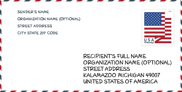
Envelop Voorbeeld

Dit is een voorbeeld van een Amerikaanse postenvelop. U kunt een 5-cijferige postcode of een gedetailleerde 9-cijferige postcode gebruiken om de mail in het volgende adresformaat te kopiëren.
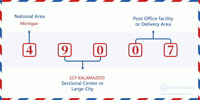
49007 Basisbetekenis
Waar staat elk cijfer van postcode 49007 voor? Het eerste cijfer geeft een nationaal gebied aan, dat varieert van nul voor het noordoosten tot negen voor het verre westen. De 2-3 cijfers zijn de code van een sectiecentrumfaciliteit in die regio. De laatste twee cijfers duiden kleine postkantoren of postzones aan.
Online landkaart

Het is een online kaart van adres Kalamazoo, Michigan, United States. U kunt Knopje gebruiken te in/uitzoomen. De kaartinformatie is alleen ter referentie.
Universiteit

This is the ZIP Code 49007 - University page list. Its detail university Name, Street, City, State, ZIP Code, Phone is as below.
| Naam | Straat | Stad | Staat | Postcode | Telefoon |
| Western Michigan University Homer Stryker M.D. School of Medicine | 300 Portage Street | Kalamazoo | MI | 49007 | (269) 337-4500 |
Ziekenhuis

Het is de Postcode 49007 - Ziekenhuis pagina lijst. Het detail Ziekenhuisnaam, straat, stad, staat, postcode, telefoon is zoals hieronder.
- Naam: BRONSON METHODIST HOSPITAL
- Adres: KALAMAZOO
- Stad: 601 JOHN STREET
- Staat: MI
- Postcode: 49007
- Telefoon: (269) 341-6000
Museum

Dit is de paginalijst van Postcode 49007 - Museum. Hieronder is het detail van Museum Naam, Straat, Stad, Staat, Postcode, Telefoon.
- Naam: KALAMAZOO NATURE CENTER
- Straat: 7000 NORTH WESTNEDGE
- Stad: KALAMAZOO
- Staat: MI
- Postcode: 49007
- Telefoon: (269) 381-1574
Bibliotheek

Dit is de paginalijst van Postcode 49007 - Bibliotheek. Hieronder is het detail van Bibliotheek Naam, Adres, Stad, Staat, Postcode, Telefoon.
| Naam | Adres | Stad | Staat | Postcode | Telefoon |
|---|---|---|---|---|---|
| ALMA POWELL BRANCH LIBRARY | 1000 WEST PATERSON STREET | KALAMAZOO | MI | 49007 | (269) 553-7960 |
| KALAMAZOO PUBLIC LIBRARY | 315 SOUTH ROSE STREET | KALAMAZOO | MI | 49007 | (269) 553-7800 |
Population for Postcode 49007

What is the total population in ZIP Code 49007? Below is detail information.
- Population for Postcode 49007: 11,051
- 2010 Bevolking: 10,762
The 2020 demographic statistics are in progress. The current population in ZIP code 49007 is 11,051, and the population in 2010 is 10,762.
Geslacht

In all the statistical population, the male population is 5,505, the female population is 5,257.
- Male Population: 5,505
- Female Population: 5,257
Race

In all the statistical population, the male population is 5,505, the female population is 5,257.
- White Population: 5,376
- Black Population: 5,417
- Hispanic Population: 511
- Asian Population: 129
- Hawaiian Population: 17
- Indian Population: 242
- Other Population: 256
Leeftijd

In all the statistical population, the White population is 5,376, the Black population is 5,417, the Hispanic population is 511, the Asian population is 129, the Hawaiian population is 17, the Indian Ppopulation is 242 and Other population is 256.
- Age's Median: 27.4
- Median of male age: 27.3
- Median of female age: 27.4
Households for Postcode 49007
ZIP code 49007 has 4,450 households, with an average number of 2.28 persons per household. The average income per household in Zip code 49007 is 31,463 USD, and the average house value is 61,400 USD.
- Households Per Zipcode: 4,450
- Personen per huishouden: 2.28
- Gemiddelde huiswaarde: 61,400
- Inkomen per huishouden: 31,463
Geographic

The latitude of the Zip code 49007 is 42.300881, the longitude is -85.594054, and the elevation is 778. It has land area of 3.606 square miles, and water area of 0.021 square miles. The time zone for ZIP code 49007 is Eastern (GMT -05:00). Daylight saving time should be observed in the area where the zip code is located.
- Breedtegraad: 42.300881
- Lengte: -85.594054
- Elevatie: 778
- Landoppervlak: 3.606
- Water Area: 0.021
- Tijd Zone: Eastern (GMT -05:00)
- Regio: Midwest
- Divisie: East North Central
- Zomertijd: Y
congresdistrict

The Congressional District for ZIP code 49007 is Michigan's 06th congressional district, the Congressional Land Area is 3546.74 square mile.
- congresdistrict: 06th
- Congresgebied: 3546.74
Levering

In the ZIP code 49007, there are 4,847 residential delivery mailboxes and centralized units, and 973 commercial delivery mailbox and centralized units, 3,385 single family deliveries and 1,208 multifamily deliveries, and the box count is 9,050. The main post office has city delivery carrier routes for the ZIP code 49007.
- Delivery Residential: 4,847
- Delivery Business: 973
- Delivery Total: 9,050
- Leveringseenheden voor één gezin: 3,385
- Multi Family Delivery Units: 1,208
- Stadsleveringsindicator: Y
Bedrijf

In ZIP code 49007, the number of business is 581, the number of employee is 16,344, the business first quarter payroll is 235,050,000 USD, the business annual payroll is 973,858,000 USD.
- Number Of Businesses: 581
- Number Of Employees: 16,344
- Zakelijke salarisadministratie eerste kwartaal: 235,050,000
- Zakelijke jaarlijkse loonlijst: 973,858,000
Sociale zekerheid

Er zijn 2,060 begunstigden met uitkeringen in de huidige betalingsstatus voor postcode 49007, waarvan 840 gepensioneerde werknemers, 765 gehandicapte werknemers, 80 weduwnaar (eren) en ouders, 35 zijn echtgenoten en 340 zijn kinderen. Het aantal begunstigden van 65 jaar of ouder is 895. De totale maandelijkse uitkeringen bedragen 2,156,000 USD, waarvan 1,081,000 USD voor gepensioneerde werknemers, 88,000 USD voor weduwnaar (eren) en ouders.
- Totaal aantal: 2,060
- Aantal gepensioneerden: 840
- Aantal gehandicapte werknemers: 765
- Weduwe / weduwnaar (er) en ouders Aantal: 80
- Echtgenoten nummer: 35
- Aantal kinderen: 340
- Alle begunstigden per maand: 2,156,000
- Gepensioneerde werknemers per maand: 1,081,000
- Weduwe (n) en ouders per maand: 88,000
- Aantal begunstigden van 65 jaar of ouder: 895


Reactie toevoegen