Verenigde Staten Postcode: 50501
Dit is de paginalijst van Iowa Postcode 50501. Hieronder is het detail van Staat, Graafschap, Stad, Lengte, Breedtegraad, Envelop Voorbeeld, Bevolking.
Postcode 50501 Informatie

-
-
Land:
U.S. - Verenigde Staten
Staat:
Staat FIPS:
19
Netnummer:
Postcode:
50501
Postcode Type:
S (Standard)
❓Wat betekent S (Standard)? Een "standaard" postcode is waar de meeste mensen aan denken als ze het over postcodes hebben - in wezen een stad, een stad of een afdeling van een stad die een postdienst heeft.
Postcode 50501 - Stad

Dit is de stadsinformatie die overeenkomt met 50501:
| Staat | Graafschap | Stad | Stadtype ?In many cases, a ZIP Code can have multiple "names", meaning cities, towns, or subdivisions, in its boundaries. However, it will ALWAYS have exactly 1 "default" name. D - Default - This is the "preferred" name - by the USPS - for a city. Each ZIP Code has one - and only one - "default" name. In most cases, this is what people who live in that area call the city as well. A - Acceptable - This name can be used for mailing purposes. Often times alternative names are large neighborhoods or sections of the city/town. In some cases a ZIP Code may have several "acceptable" names which is used to group towns under one ZIP Code. N - Not Acceptable - A "not acceptable" name is, in many cases, a nickname that residents give that location. According to the USPS, you should NOT send mail to that ZIP Code using the "not acceptable" name when mailing. | Postcode |
|---|---|---|---|---|
| IA | Webster | Clayworks | N (Not Acceptable) | 50501 |
| IA | Webster | Coalville | N (Not Acceptable) | 50501 |
| IA | Webster | Crossroads Center | N (Not Acceptable) | 50501 |
| IA | Webster | Fort Dodge | D (Default) | 50501 |
| IA | Webster | Palm Grove | N (Not Acceptable) | 50501 |
| IA | Webster | Tara | N (Not Acceptable) | 50501 |
| IA | Webster | West Fort Dodge | N (Not Acceptable) | 50501 |
❓Wat betekent D (Default)? Dit is de "geprefereerde" naam - door de USPS - voor een stad. Elke postcode heeft één - en slechts één - "standaard" naam. In de meeste gevallen noemen mensen die in dat gebied wonen de stad ook.
❓Wat betekent N (Not Acceptable)? Een "niet acceptabele" naam is in veel gevallen een bijnaam die bewoners aan die locatie geven. Volgens de USPS mag je GEEN post naar die postcode sturen met de "niet acceptabele" naam bij het mailen.
Postcode 50501 Plus 4
ZIP Code 5 plus 4 is de uitbreiding van de 5-cijferige postcode, het kan worden gebruikt om een meer gedetailleerde locatie te vinden. De laatste vier cijfers duiden een segment of een kant van een straat of een appartement aan. Hieronder vindt u de postcode en het bijbehorende adres van de postcode 50501.
| Postcode 5 Plus 4 | Adres |
|---|---|
| 50501-0001 | PO BOX 1, FORT DODGE, IA |
| 50501-0151 | PO BOX 151, FORT DODGE, IA |
| 50501-0301 | PO BOX 301, FORT DODGE, IA |
| 50501-0451 | PO BOX 451, FORT DODGE, IA |
| 50501-0460 | 809 CENTRAL AVE #00000450 , FORT DODGE, IA |
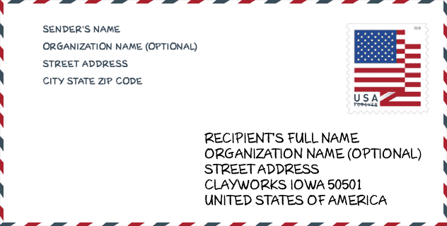
Envelop Voorbeeld

Dit is een voorbeeld van een Amerikaanse postenvelop. U kunt een 5-cijferige postcode of een gedetailleerde 9-cijferige postcode gebruiken om de mail in het volgende adresformaat te kopiëren.
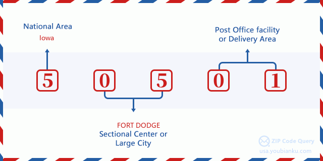
50501 Basisbetekenis
Waar staat elk cijfer van postcode 50501 voor? Het eerste cijfer geeft een nationaal gebied aan, dat varieert van nul voor het noordoosten tot negen voor het verre westen. De 2-3 cijfers zijn de code van een sectiecentrumfaciliteit in die regio. De laatste twee cijfers duiden kleine postkantoren of postzones aan.
Online landkaart

Het is een online kaart van adres West Fort Dodge, Iowa, United States. U kunt Knopje gebruiken te in/uitzoomen. De kaartinformatie is alleen ter referentie.
Universiteit

This is the ZIP Code 50501 - University page list. Its detail university Name, Street, City, State, ZIP Code, Phone is as below.
| Naam | Straat | Stad | Staat | Postcode | Telefoon |
| Iowa Central Community College | One Triton Circle | Fort Dodge | IA | 50501 | (515) 576-7201 x1148 |
| La James International College-Ft Dodge | 2419 5th Avenue South | Fort Dodge | IA | 50501 | (515) 576-3119 |
Ziekenhuis

Het is de Postcode 50501 - Ziekenhuis pagina lijst. Het detail Ziekenhuisnaam, straat, stad, staat, postcode, telefoon is zoals hieronder.
- Naam: TRINITY REGIONAL MEDICAL CENTER
- Adres: FORT DODGE
- Stad: 802 KENYON RD
- Staat: IA
- Postcode: 50501
- Telefoon: (515) 573-3101
Museum

Dit is de paginalijst van Postcode 50501 - Museum. Hieronder is het detail van Museum Naam, Straat, Stad, Staat, Postcode, Telefoon.
| Naam | Straat | Stad | Staat | Postcode | Telefoon |
| BLANDEN MEMORIAL ART MUSEUM | 920 3RD AVENUE SOUTH | FORT DODGE | IA | 50501 | (515) 573-2316 |
| WEBSTER COUNTY HISTORICAL SOCIETY | PO BOX 543 | FORT DODGE | IA | 50501 | |
| TRITON ART GALLERY | ONE TRITON CIRCLE | FORT DODGE | IA | 50501 | (515) 576-7201 |
Bibliotheek

Dit is de paginalijst van Postcode 50501 - Bibliotheek. Hieronder is het detail van Bibliotheek Naam, Adres, Stad, Staat, Postcode, Telefoon.
- Naam: FORT DODGE PUBLIC LIBRARY
- Adres: 424 CENTRAL AVE
- Stad: FORT DODGE
- Staat: IA - Iowa
- Postcode: 50501
- Telefoon: (515) 573-8167
School
Dit is de paginalijst van Postcode 50501 - School. Hieronder is het detail van School Naam, Adres, Stad, Staat, Postcode.
| School Naam | Adres | Stad | Staat | Klassen | Postcode |
|---|---|---|---|---|---|
| Butler Elementary School | 945 SOUTH 18TH STREET | Fort Dodge | IA | UG | 50501 |
| Cooper Elementary School | 2420 14TH AVENUE NORTH | Fort Dodge | IA | UG | 50501 |
| Duncombe Elementary School | 1620 6TH AVENUE NORTH | Fort Dodge | IA | UG | 50501 |
| Feelhaver Elementary School | 1300 14th Ave N | Fort Dodge | IA | UG | 50501 |
| Fort Dodge High School | 819 N 25th St | Fort Dodge | IA | UG | 50501 |
| Early Childhood Center | 104 So. 17th St. | Fort Dodge | IA | UG | 50501 |
| Fort Dodge Middle School | 800 NORTH 32ND STREET | Fort Dodge | IA | UG | 50501 |
Population for Postcode 50501

What is the total population in ZIP Code 50501? Below is detail information.
- Population for Postcode 50501: 27,265
- 2010 Bevolking: 29,078
The 2020 demographic statistics are in progress. The current population in ZIP code 50501 is 27,265, and the population in 2010 is 29,078.
Geslacht

In all the statistical population, the male population is 14,931, the female population is 14,147.
- Male Population: 14,931
- Female Population: 14,147
Race

In all the statistical population, the male population is 14,931, the female population is 14,147.
- White Population: 26,925
- Black Population: 1,777
- Hispanic Population: 1,341
- Asian Population: 299
- Hawaiian Population: 35
- Indian Population: 204
- Other Population: 464
Leeftijd

In all the statistical population, the White population is 26,925, the Black population is 1,777, the Hispanic population is 1,341, the Asian population is 299, the Hawaiian population is 35, the Indian Ppopulation is 204 and Other population is 464.
- Age's Median: 38.4
- Median of male age: 34.3
- Median of female age: 42.6
Households for Postcode 50501
ZIP code 50501 has 11,848 households, with an average number of 2.24 persons per household. The average income per household in Zip code 50501 is 41,563 USD, and the average house value is 98,900 USD.
- Households Per Zipcode: 11,848
- Personen per huishouden: 2.24
- Gemiddelde huiswaarde: 98,900
- Inkomen per huishouden: 41,563
Geographic

The latitude of the Zip code 50501 is 42.455955, the longitude is -94.196530, and the elevation is 1124. It has land area of 155.996 square miles, and water area of 1.231 square miles. The time zone for ZIP code 50501 is Central (GMT -06:00). Daylight saving time should be observed in the area where the zip code is located.
- Breedtegraad: 42.455955
- Lengte: -94.196530
- Elevatie: 1124
- Landoppervlak: 155.996
- Water Area: 1.231
- Tijd Zone: Central (GMT -06:00)
- Regio: Midwest
- Divisie: West North Central
- Zomertijd: Y
congresdistrict

The Congressional District for ZIP code 50501 is Iowa's 04th congressional district, the Congressional Land Area is 22756.75 square mile.
- congresdistrict: 04th
- Congresgebied: 22756.75
Levering

In the ZIP code 50501, there are 12,172 residential delivery mailboxes and centralized units, and 1,045 commercial delivery mailbox and centralized units, 10,473 single family deliveries and 1,090 multifamily deliveries, and the box count is 13,598. The main post office has city delivery carrier routes for the ZIP code 50501.
- Delivery Residential: 12,172
- Delivery Business: 1,045
- Delivery Total: 13,598
- Leveringseenheden voor één gezin: 10,473
- Multi Family Delivery Units: 1,090
- Stadsleveringsindicator: Y
Bedrijf

In ZIP code 50501, the number of business is 863, the number of employee is 15,638, the business first quarter payroll is 155,144,000 USD, the business annual payroll is 646,194,000 USD.
- Number Of Businesses: 863
- Number Of Employees: 15,638
- Zakelijke salarisadministratie eerste kwartaal: 155,144,000
- Zakelijke jaarlijkse loonlijst: 646,194,000
Sociale zekerheid

Er zijn 6,355 begunstigden met uitkeringen in de huidige betalingsstatus voor postcode 50501, waarvan 4,470 gepensioneerde werknemers, 905 gehandicapte werknemers, 395 weduwnaar (eren) en ouders, 190 zijn echtgenoten en 395 zijn kinderen. Het aantal begunstigden van 65 jaar of ouder is 4,785. De totale maandelijkse uitkeringen bedragen 8,555,000 USD, waarvan 6,533,000 USD voor gepensioneerde werknemers, 554,000 USD voor weduwnaar (eren) en ouders.
- Totaal aantal: 6,355
- Aantal gepensioneerden: 4,470
- Aantal gehandicapte werknemers: 905
- Weduwe / weduwnaar (er) en ouders Aantal: 395
- Echtgenoten nummer: 190
- Aantal kinderen: 395
- Alle begunstigden per maand: 8,555,000
- Gepensioneerde werknemers per maand: 6,533,000
- Weduwe (n) en ouders per maand: 554,000
- Aantal begunstigden van 65 jaar of ouder: 4,785


Reactie toevoegen